Reforestamos México A.C. Success Story
This case study explores Reforestamos México A.C. (RM), a visionary organization dedicated to forest conservation since 2002. Facing outdated environmental data, RM partnered with Orbify, leveraging satellite technology for environmnental analytics. This collaboration streamlined data acquisition, enhancing forest management efforts and expanding analytical capabilities.

The Journey of Reforestamos México A.C.
Since its inception in 2002, Reforestamos México A.C. (RM) has dedicated itself to a pivotal mission: to ensure the preservation and enhancement of forests for the promotion of sustainable development. The organization is committed to identifying and implementing innovative solutions aimed at curbing deforestation, promoting the sustainable management of forests, restoring lands that have suffered degradation, and supporting urban afforestation efforts. Central to its strategy is the development of cross-sector partnerships that include youth, local communities, and the private sector. Through these collaborations, Reforestamos México A.C. strives to create a more sustainable future, underlining the essential role of forests in ecological balance and human well-being.
The challenge: The Data Dilemma of Reforestamos México A.C.
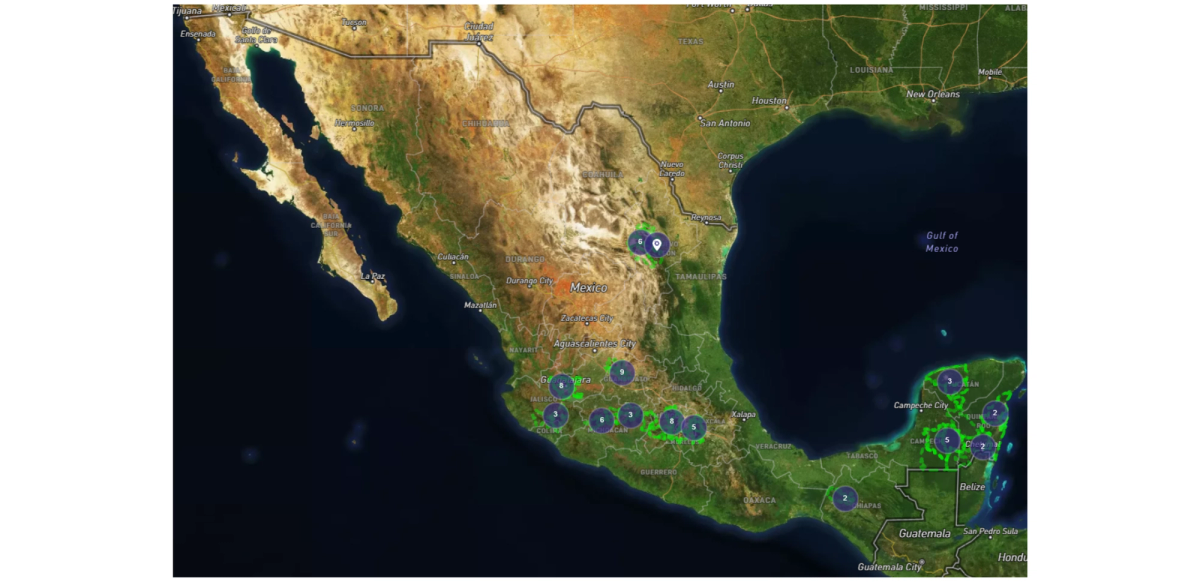
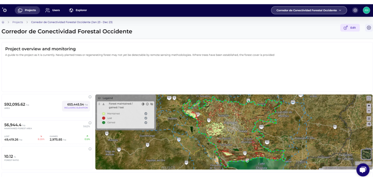
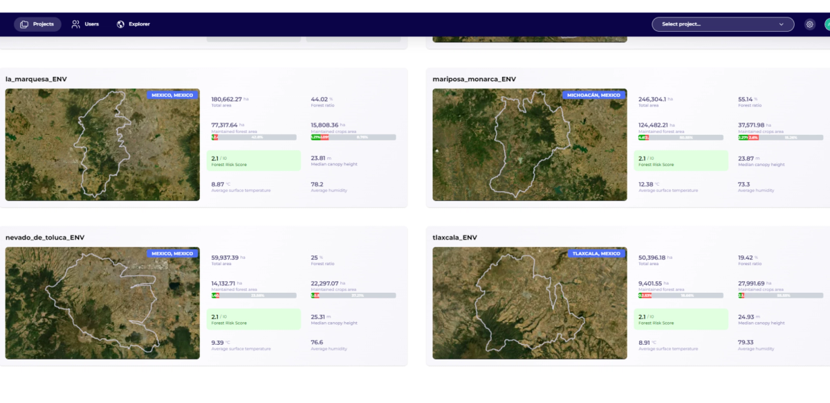
Reforestamos México A.C. (RM) faced a significant challenge in enhancing its impact on sustainable forest management across Mexico. In 2020, the organization utilized geographic information systems to map 8 strategic areas across the country, covering over 12 million hectares, for focused conservation activities.
However, obtaining updated and reliable environmental data proved difficult, as governmental sources were often slow and outdated. To address this, RM turned to LandSat 8 satellite imagery for a more accurate baseline of land use and vegetation. This necessity for timely data led them to partner with Orbify, a platform that simplified data acquisition and provided automated updates, thus extending RM’s analytical capabilities beyond its initial targets. Orbify’s innovative approach perfectly aligned with RM’s mission, offering a strategic solution to the challenge of integrating cutting-edge tools for more efficient environmental planning and action.
The solution: Harnessing Orbify's Capabilities
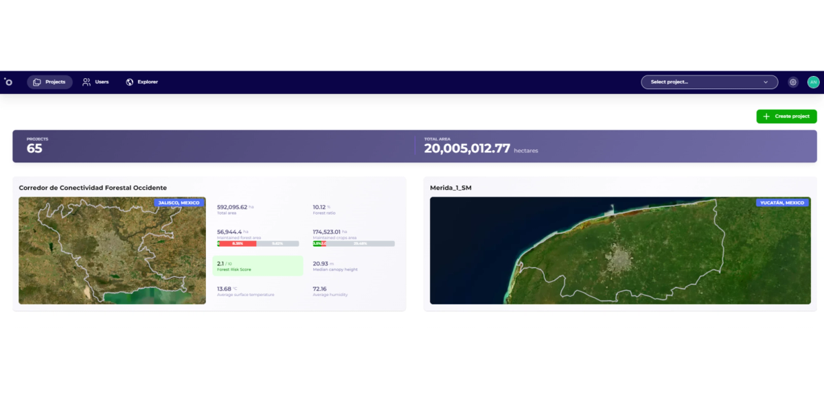
Reforestamos México A.C. effectively addressed its data acquisition challenges by integrating Orbify into its environmental monitoring and planning processes. Orbify's platform streamlined the updating of crucial environmental information, eliminating the need to download large satellite images that consume significant computer memory and processing power. This not only alleviated the strain on computational resources but also significantly reduced the time typically required for manual data processing. With Orbify's automation, the organization could quickly access updated data, enhancing its ability to respond to environmental changes in a timely manner. Additionally, Orbify expanded Reforestamos México A.C.'s analytical reach, enabling the examination of areas beyond the initially defined polygons without baseline data, thus broadening the scope of their conservation efforts.
Looking Forward: Future Directions of Reforestamos México A.C
Reforestamos México A.C. envisions incorporating the insights gained from Orbify into a comprehensive datasheet for each corridor. This datasheet will collate both historical and current data, meticulously organized to serve as a foundational reference for crafting proposals and projects in collaboration with the private sector. This strategic integration of data aims to bolster the organization's capacity for informed decision-making and enhance its advocacy for sustainable forest management initiatives.
"I like that Orbify directly generates forest coverage percentage indicators and calculates the corresponding loss for the period of interest. I also enjoy how the maps are visualized. It's interesting to be able to use a platform that in a very simple way allows for analysis for different seasons." Andrea Álvarez Pérez - GIS Analyst at Reforestamos México


