Visualizing Impact at Scale: How EarthDefine Uses Orbify to Power Urban Forestry Nationwide
EarthDefine delivers high-resolution geospatial data with accuracy and at a scale often unparalleled by commercial or federal sources. With Orbify, they're transforming that data into a strategic delivery platform - making it not only instantly accessible and visual but also scalable and actionable across applications. EarthDefine and its partners including the US Forest Service, the Arbor Day Foundation, and PlanIt Geo, use Orbify’s interface for live demos with their potential clients.
The collaboration with Orbify - bringing both technical agility and delivery expertise - enabled them to build the first ever commercial solution for high resolution tree canopy across the United States. This project empowers communities, partners, and clients to take action based on what they can clearly see.
The Challenge
EarthDefine’s mission is to transform raw imagery into highly accurate, high-resolution datasets that are easy to use and understand. Specializing in remote sensing and machine learning, they generate detailed land cover classifications, tree canopy data, and more across massive areas - usually nationwide.
“The best available data out there at that scale was a 30 Meter NLCD data product. And now we have tree canopy information at 60 centimeters compared to 30 meters. It's far more consumable and useful when it's accurately showing what's on the ground.” - Taylor McDowell, Geospatial Project Manager at EarthDefine.
But how do you show that scale and resolution to stakeholders in a clear and intuitive way?
As EarthDefine’s tree canopy and land cover products gained traction in sectors such as urban forestry, they saw a growing need for a visualization and hosting platform that could help prospective clients and partners instantly access and explore their data. They needed a tool that could host enormous raster files, provide smooth visual experiences, and offer the flexibility to scale across use cases.
The Solution
EarthDefine turned to Orbify to help close the gap between massive data and meaningful insights. By integrating their tree canopy and land cover raster datasets directly into Orbify’s platform, they were able to visualize their national-scale data with ease.
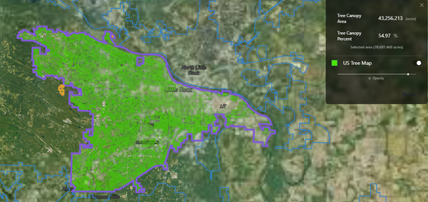
“It was critical for us to show our clients what their tree canopy looks like on a very local level. Doing so with ease proved to be a major hurdle for us,” said McDowell. “That’s how we found Orbify and now we host all of our tree canopy raster data with them. Being able to move several terabytes of raster data and visualize it in its entirety in a matter of a few days is pretty mind-boggling ”
Today, EarthDefine and partners like PlanIt Geo use Orbify-hosted layers to engage communities, policymakers, and clients in meaningful conversations where they seamlessly pull up detailed maps of local tree cover or land use within seconds.
“To sit down with a city and say, ‘Here’s your tree canopy.’ And actually show it live is a ‘game changer.’ That kind of visual access inspires confidence in the data,”
said McDowell.
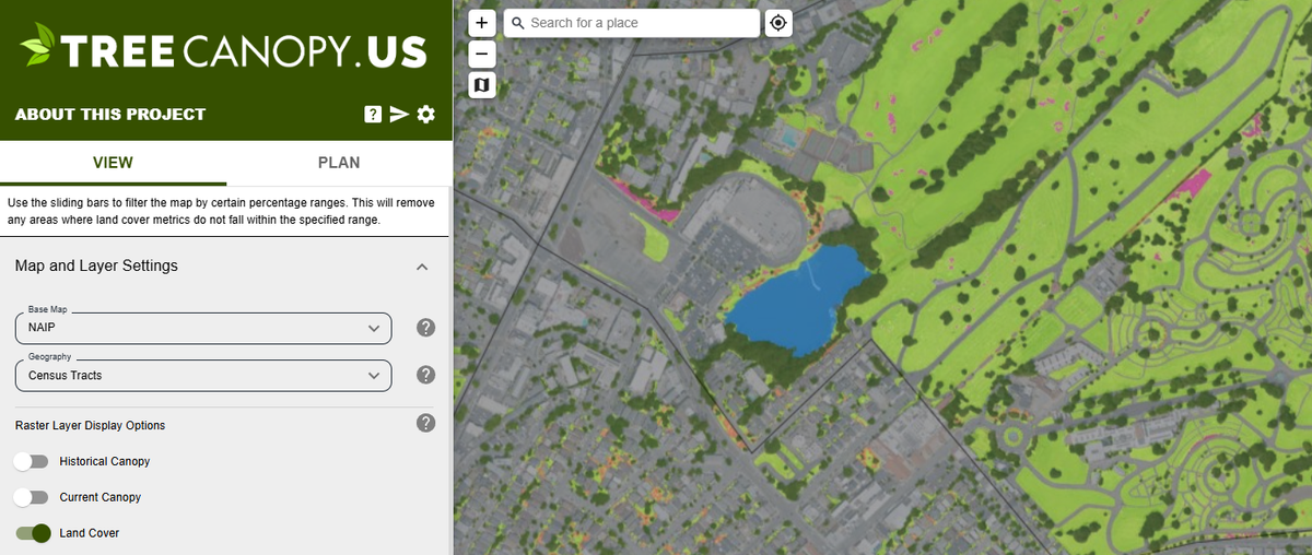
This functionality was recently put to the test in EarthDefine’s collaboration with the U.S. Forest Service, the Arbor Day Foundation, and PlanIt Geo, resulting in treecanopy.us - the first nationwide urban tree canopy assessment. The site pulls directly from Orbify-hosted data to give users a real-time look at canopy coverage in their communities.
Why Orbify
While other platforms offered prebuilt solutions, EarthDefine needed more than a one-size-fits-all tool.
What set Orbify apart was their flexibility and willingness to build with us,"
they shared.
“We’ve worked with other platforms, and they were great – until we hit a wall. Orbify, on the other hand, always finds a way to scale, adapt, and customize.”
The collaboration has been hands-on, with Orbify’s team supporting everything from technical troubleshooting to personalized customer support.
“I don’t think we could’ve delivered a project like treecanopy.us without Orbify’s responsiveness. They’ve saved me a million headaches and it made all the difference,”
said McDowell.
Results
- Seamless visualization of nationwide tree canopy and land cover data: EarthDefine uses Orbify to quickly access compelling visuals of their data covering over 8.1 million square km of forest canopy to demonstrate to prospective clients.
- Orbify empowers EarthDefine with an unparalleled opportunity to showcase products, increase sales, and further contributions in urban forestry, green infrastructure, natural resource management, and urban planning and development.
- Orbify’s 477,000 sq. km of land cover and tree canopy raster classification data covering all urban areas and census places across the US, territories and protectorates are embedded in treecanopy.us to provide the first-ever national-scale U.S. urban tree canopy assessment.
- Enabled treecanopy.us to launch flawlessly under immense time pressure
- Empowered partners like PlanIt Geo to conduct real-time urban forestry analysis
- Strengthened client engagement through intuitive, live data interaction
- Established a scalable, flexible platform for future data products
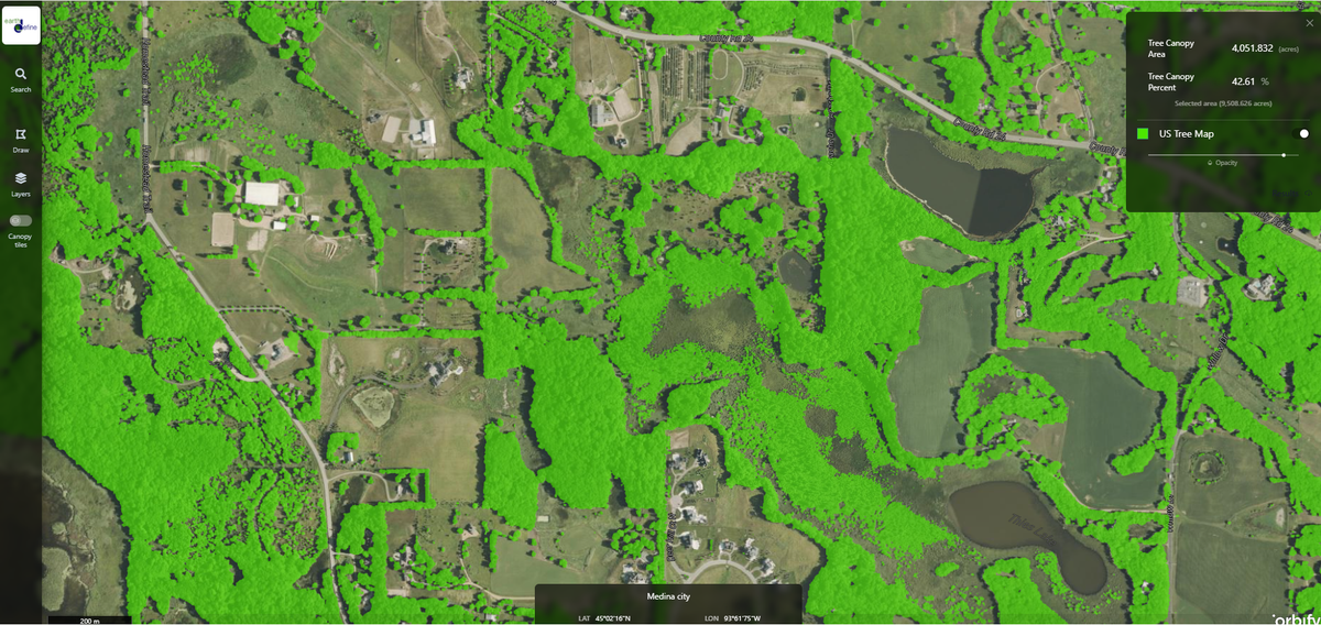
- Orbify hosts EarthDefine’s US Tree Map product, which is a 60cm tree canopy raster classification across the United States.
Orbify’s flexibility and responsiveness have enabled EarthDefine to not only deepen their current use but also to explore entirely new product models that rely on scalable, client-facing delivery of geospatial insights to dream up the next potential collaborative undertaking already.
While the full impact is still being quantified, one thing is clear: Integrating Orbify has unlocked new potential in how EarthDefine’s data is shared, understood, and acted upon.
What’s Next
EarthDefine plans to expand its use of Orbify beyond tree canopy - potentially including high-resolution land cover and building footprint datasets. They're also exploring embedding Orbify maps directly into their website, offering clients a self-serve way to explore sample data.
One dream feature? Letting users extract sample GeoTIFFs directly from a map interface. And with Orbify’s track record for flexibility, it might not stay a dream for long.
EarthDefine deals in big data, and Orbify gives them the tools to make that data tangible. That changes how people engage with it. That’s the power of this partnership.
About EarthDefine
Founded in 2013, EarthDefine produces high-resolution, machine-learning-powered geospatial datasets with national coverage. Their products—including sub-meter tree canopy maps and building footprints—are trusted by urban foresters, local governments, and sustainability leaders across the United States.


