Monitoring & Mapping Air Quality Data from Satellites
Absiskey and Orbify collaborated to develop a cloud-based mapping tool that combines air quality data, satellite imagery, and land cover data to help municipalities, city planners, and commercial parties visualize air quality data on a map with the aid of air quality prediction models.

Customer
Absiskey Polska is a Polish consulting firm that advises space companies. Apart from companies already active in space, it advises those who want to join the space and support their proposals for funding programs of the European Space Agency (ESA).
Problem
As part of a recent ESA project, Absiskey Polska needed the creation of an air quality data application that uses satellite imagery, meant for local, Polish authorities and European startups that may want to add their own, private (sensor) data to it to get even more reliable air data quality analysis. Orbify provided access to a ready-to-use remote sensing data analysis platform using machine learning models, along with a set of templates for developing fully functional interactive applications and dashboards. These were precisely the features Absiskey Polska was seeking.
Solution
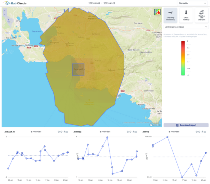
The application blends data from different sources together on a mapping interface that shows how air data quality fluctuates over a period of time on a 2D map. This mapping interface can be manipulated by the user, who can zoom in on a certain region of interest. A dashboard with graphs and stats shows the air data quality for that region, in terms of whether formaldehyde concentrations exceed a certain tolerance level (formaldehyde is a chemical that can cause cancer when exposed to large concentrations over time).
Especially the air data quality prediction models information can be used by city planners for the creation of “heat maps” to show citizens where air quality will be problematic or just the opposite. This enables citizens to plan certain outdoor activities better, without having to face the consequences of bad air quality on their personal health. They can also see where in a city are the most polluted areas, so they can see if they live in a healthy area or not. Politicians can use these data to protect people from poor air quality and construct domes to organize meetups or different kinds of events to spend time in a less-polluted area.
The data sources are Sentinel-5 satellite imagery, land cover data and air data quality prediction models. The land cover data comes from Copernicus, a European programme for monitoring the Earth. They collect CORINE Land Cover (CLC) data, an inventory of land cover classes based on multiple satellite imagery sources. The air data quality prediction models come from the Copernicus Atmosphere Monitoring Service (CAMS), which provides consistent and quality-controlled information related to air pollution and health, solar energy, greenhouse gasses and climate forcing.
Result
The technical requirements from Absiskey Polska were met in time by Orbify, who created a data workflow that blends the three types of spatial data in an easy-to-use mapping interface for the end user. Absiskey Polska was very happy with Orbify’s application development capabilities and the results. Most of all, what really made the difference compared to others was how fast the company operates, says Pawel Kwiatkowski:
“They created this great application that met all our needs in a very short time. This was also necessary, as we didn’t have much preparation time. By using Orbify’s templates, we were able to quickly access what we were looking for and create an intuitive user interface that enables city planners to quickly take advantage of insights around air data quality for their area of interest.”
Orbify and Absiskey Polska's collaboration resulted in a cloud-based mapping application that combined satellite imagery, land cover data, and air quality prediction models to provide an easy-to-use interface for monitoring air quality data. The application has the potential to contribute to sustainable development by enabling risk mitigation and informed decision-making processes for air quality initiatives.


