Last edited: November 15, 2023
Published: November 15, 2023

Orbify
Earth Intelligence Specialists
Blog Post
Last edited: November 15, 2023
Published: November 15, 2023
Orbify
Earth Intelligence Specialists
In the Orbify Review, we pick an NbS project related to the Voluntary Carbon Market from one of the credible registries and review it using our Geospatial Data Platform (GDP) to show how can you use and take advantage of our platform to analyse a VCM project or even to monitor and use the data to include in your PDD on the project development.
For this Review, we've selected The Valparaiso Project located in Acre state, Brazil. The project is registered on Verra Registry.
The Valparaiso Project seeks to help protect and conserve tropical forest by providing payments for ecosystem services. This type of project is known as a Reducing Emissions from Deforestation and forest Degradation project (REDD project). Project activities intended to reduce deforestation are implemented in and around a privately-owned property in the State of Acre, Brazil and are funded by payments related to emission reduction credits generated by the project.
This project is being developed and registered under the Verified Carbon Standard (VCS) and the Climate, Community and Biodiversity Standard (CCBS). Project development involved working with the local communities surrounding the project area, engaging Acre state officials working on similar strategies at a regional/state level, developing a plan which will result in lowering the pressure on land and forest resources in consultation with the local community, and putting into operation the REDD project implementation plan with the help of local partners. Activities implemented as part of the project to reduce deforestation include:
There are three project proponents undertaking the Valparaiso Project including CarbonCo, LLC (“CarbonCo”), Freitas International Group, LLC (“Carbon Securities”), and Manoel Batista Lopes, ME. CarbonCo, the wholly-owned subsidiary of Carbonfund.org, is responsible for project finance and managing project development. Carbon Securities acts as a liaison between CarbonCo and Manoel Batista Lopes, ME and provides logistical support during site visits. Manoel Batista Lopes is the land owner and sole proprietor of Manoel Batista Lopes, ME an Acre based organization which is primarily responsible for implementation of project activities and day-to-day management of the Valparaiso Project.
In conclusion, the Valparaiso Project will mitigate deforestation pressures using a combination of environmental programs and social programs which are intended to improve the livelihoods of community members living in the vicinity of the project area. Social projects and programs for the local communities, will not only generate sustainable economic opportunities, but will also result in a reduction in deforestation and the preservation of biodiversity
In our review we will access the 3 areas that can be found on the PDD, the Project Area, the Leakage Area and the Reference Area, we are not considering any potential changes in the area since the first PDD submission as well the second baseline assessment, our aim is not to create ratings or guide the buyer on the question if they should invest on that project or not, we will just show how our platform can be used to analyses the project of interest, if you are interested in project investment consultancy please contact us.
We then uploaded the project area on our GDP and selected the dates of the analysis so we can see the dashboard and map with the indicators. For this particular example, we choose the dates to cover the data from 2020.07.01 until 2023.07.01. Let's have a look at the change analysis derived from GDP:
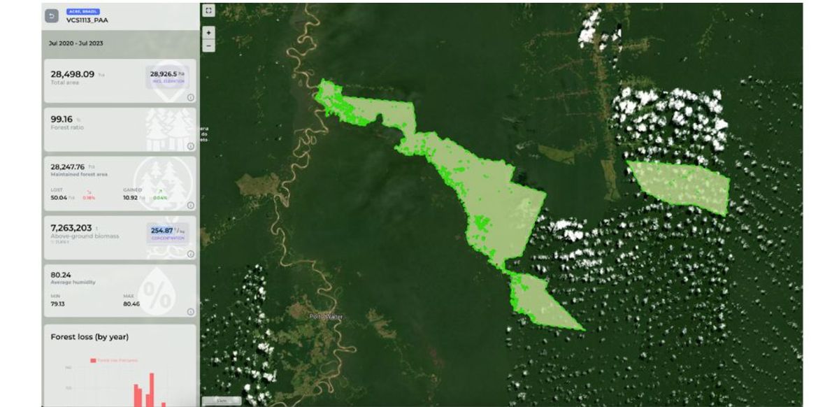
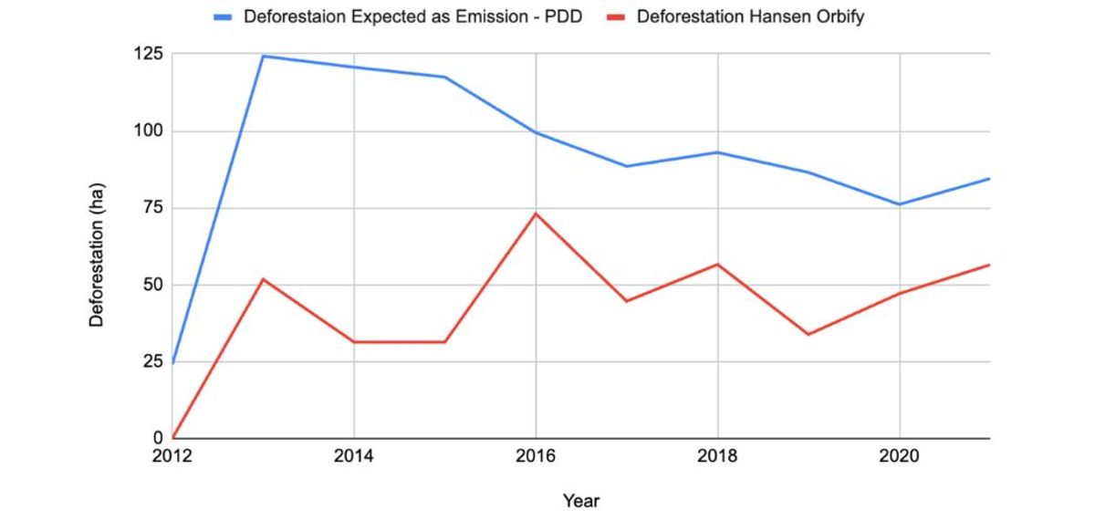
By checking the data it is possible to see the amount of maintained forest and deforestation/ degradation in the area. Interestingly, the area is located in one area of high threat of deforestation and is being quite successful in stopping the clear-cutting inside the area.
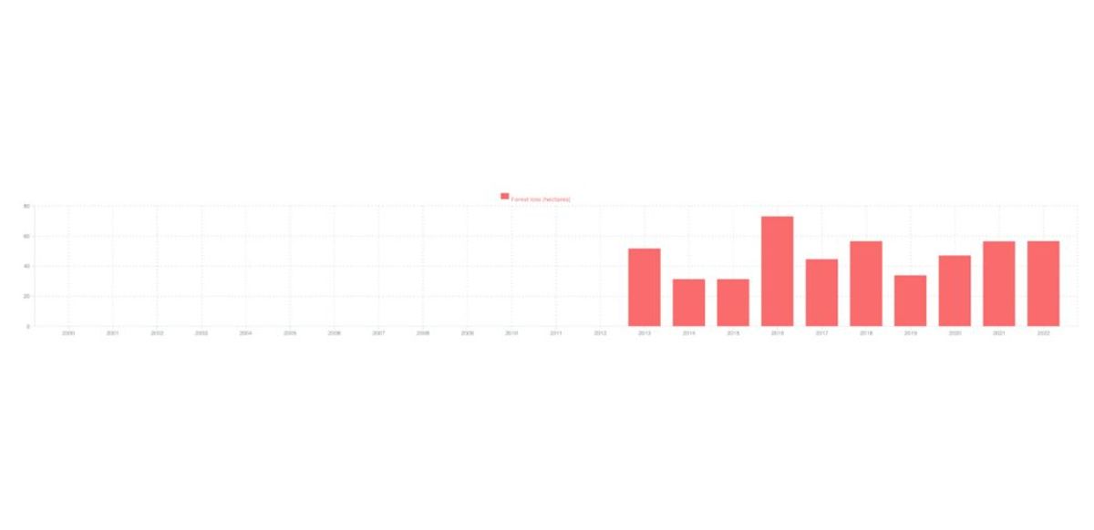
It is possible to see on the Hansen chart below some deforestation happening in the area, but in a really small intensity, which indicates that the project seems to be doing a good job in protecting the forest:

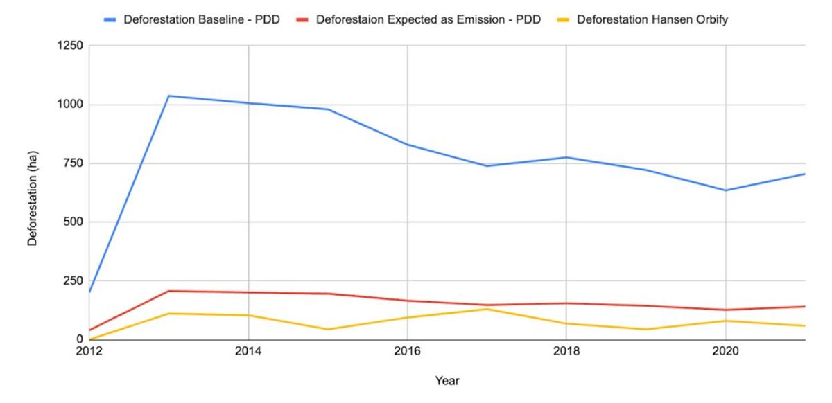
Comparing with the data from the baseline and project emissions we can see that the project is being effective and keeping the forest protected.
Now, let's analyse the leakage area, which we also could retrieve from the PDD and run our analysis on it, as you can see below:
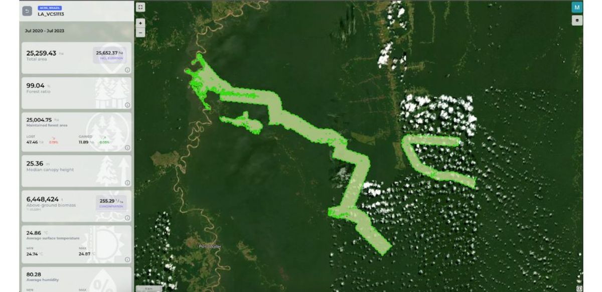
Interestingly they also estimate that the Leakage Belt would suffer some deforestation with the project implementation, and the data shows that they were successful in keep the deforestation on leakage under the expected values.
On the methodology VM007 it is needed to set up a Reference Area to calculate the rate of deforestation, we could extract the reference area from the PDD and we demonstrate on the chart below the deforestation in the ten years before the project start date compared to what they claimed that was deforested and used for their baseline.
It was analysed the 10 years before the project start date and then compared with the data from the Project Developers, the problem is that we just had data from 2001 - 2010 and not 1999 - 2010.
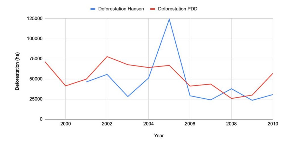
The project developer then shows the average value which differs from the value that 53117,33 ha/year was deforested, in the other hand we found using the Hansen data that 45096,47 ha/year was deforested.
In the end, the project developer used a model to predict the potential deforestation that would occur on the project without the establishment of conservation, which can be seen in the first chart presented in this report.
In conclusion, we can see that some deforestation in a small scale, and that was expected as project emissions since the project implementation. The project seems to be effective in stop deforestation in the project area and in the Leakage area after the implementation of the activities. Besides that we demonstrated some simple concepts of the VM0007 methodology from VERRA for REDD projects, and also how it is important to use accurate data to be able to properly report your emissions avoidance.
On this review, we showed how we can use the geospatial data platform to quickly and easily access a NbS project and its historical activities on the area, giving insightful information and helping on the decision making of developers, investors and government.
The objective of this review is to showcase the power of our geospatial data platform in presenting data objectively. We refrain from drawing any conclusions on the project's success but rather focus on demonstrating how Earth Observation (EO) data can be invaluable in all stages of planning, monitoring, and verifying REDD projects.