Last edited: August 27, 2024
Published: August 14, 2024

Orbify
Earth Intelligence Specialists
Blog Post
Last edited: August 27, 2024
Published: August 14, 2024
Orbify
Earth Intelligence Specialists
The Makame Wildlife Management Area (WMA) is a vast conservation area spanning 364,322 hectares in Northern Tanzania. Located approximately 100 kilometers north of Kibaya, Kiteto, the WMA lies between latitudes 5º50'26.09'' and 5º51'38.14'' South, and longitudes 36º47'23.35'' and 36º50'58.94 East. This community-managed protected area encompasses five villages: Irkiushiobor, Ndedo, Ngábolo, Katikati, and Makame, with a total population of 14,854 as of the 2012 census.
The Makame WMA is characterized by a semi-arid climate, receiving between 500mm to 750mm of annual rainfall. Its landscape is dominated by open woodlands and mixed shrubland, providing crucial habitat for a diverse array of wildlife, including elephants, lions, buffalos, giraffes, leopards, oryx, and various antelope species.
Governance of the WMA is entrusted to an Authorized Association (AA), which includes representatives from all five member villages. This participatory management structure ensures local involvement in conservation efforts and decision-making processes. The Resource Management Zone Plan (RMZP) divides the WMA into three distinct management zones: a hunting management subzone, a carbon project management subzone, and a photographic management subzone.
The RMZP outlines several key objectives for the Makame WMA, including protecting and conserving natural resources, promoting sustainable tourism, improving the livelihoods of WMA communities, securing land rights, strengthening governance, and preserving local culture and traditions. To achieve these goals, the WMA aims to generate revenue through various means, including hunting tourism, photographic safaris, and potentially carbon offset projects.
However, the management of Makame WMA is not without challenges. The plan addresses issues such as human-wildlife conflict, poaching, wildfires, and the need for improved infrastructure and community services. To tackle these challenges and ensure the successful implementation of the RMZP, the plan emphasizes stakeholder involvement at multiple levels. It delineates specific roles for village councils, district government, and NGO partners in supporting the WMA's objectives.
Before we start the evaluation of Makame Wildlife Management Area we want to point out that Orbify Review is not to rate or advise on investment opportunities but to demonstrate how our platform can be used to analyze projects of interest.
Project Type: Agriculture, Forestry, and Other Land Use (AFOLU), specifically focusing on REDD (Reduced Emissions from Deforestation and Degradation).
VCS Methodology: The project uses VM0007 methodology.
Hectares: The project area covers 104,065 hectares.
Description: The Makame Savannah REDD project aims to reduce deforestation and forest degradation in the Kiteto District of Tanzania. It implements a comprehensive management plan that balances wildlife conservation with community development, including anti-poaching efforts, sustainable tourism development, strengthening governance, securing land rights, and preserving local culture and traditions.
Benefits to Climate: The project is estimated to reduce emissions by 136,411 tonnes of CO2e annually, with total buffer pool credits amounting to 281,992.
Benefits to Communities: The project aims to improve the livelihoods of local communities through the sustainable management of natural resources, improved governance, and the preservation of Maasai culture and traditions. Carbon Tanzania, based in Kent, United Kingdom, is the project proponent working with local communities.
Benefits to Biodiversity: The project protects crucial habitats for various wildlife species and maintains ecosystem connectivity within the larger landscape, typical of REDD projects in this region.
- The project was registered with VCS on 02/10/2020.
- The crediting period is from 27/04/2016 to 26/04/2046.
- The project has been validated and verified under both VCS and CCB standards.
- EPIC Sustainability Services Private Limited conducted the first verification, while Aster Global Environmental Solutions conducted the second and third verifications.
To kick off our analysis, we begin by reviewing the project’s description document, followed by an evaluation through our platform to verify the project's land use categories. Notably, the description document does not clearly define the unique land use classes across different areas. It only briefly mentions in Section 2.4 (Wildlife and Vegetation Communities) that the Makame WMA primarily consists of "open woodlands and mixed shrubland." However, it lacks a detailed comparison of these land use classes between the project area, leakage belt, and reference area. Instead, the document focuses more on management strategies and permitted uses within the Makame WMA itself.
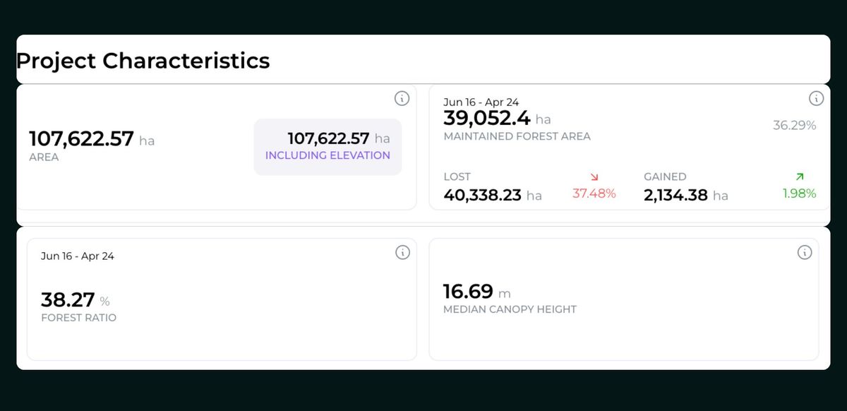
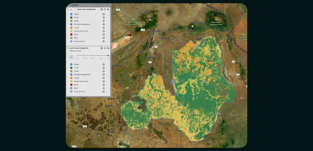
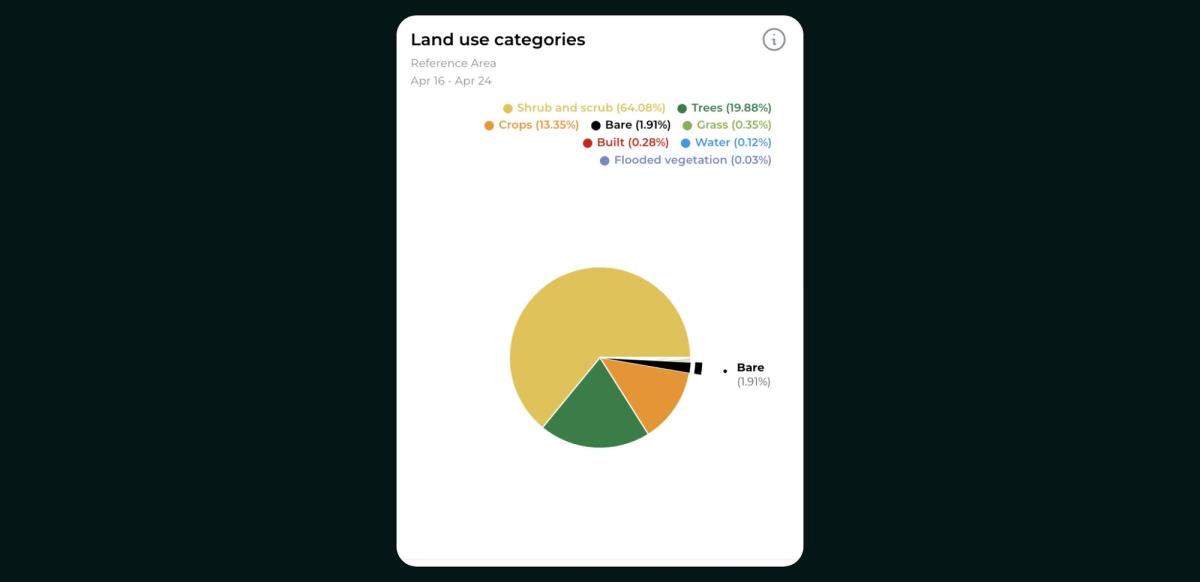
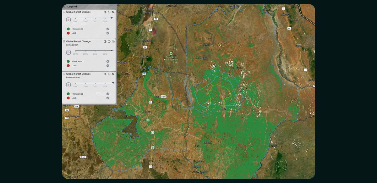
After reviewing the project document, we started our analysis through Orbify's satellite data-powered platform. We analyzed and visualized the unique land use categories within the project area, leakage belt, and reference area. This provides valuable insights to support project management. The analysis reveals that shrub and scrub cover the majority of the area. However, it also identifies additional land use classes, including crops, grass, bare soil, man-made structures, and flooded vegetation. Furthermore, Orbify enables you to monitor changes in land use over time, particularly from 2016, when the project began, up until the present day in 2024. Overall, Orbify's capabilities to categorize and track land use patterns can offer important context to inform project decision-making and assessments.
The project description indicates that deforestation is an increasing threat in the region. Based on the project’s document historical deforestation was analyzed for the period 2005-2015 using classified Landsat imagery. For the broader Reference Region for Deforestation (RRD), which includes the project area and leakage belt, the annual deforestation rates were:
- 2005-2010: 162,738 ha/yr
- 2010-2015: 199,332 ha/yr
- Average: 181,035 ha/yr
The project description does not provide specific historical deforestation numbers for just the project area or leakage belt. However, it does provide projected baseline deforestation for these areas:
- Project Area (104,065 ha total): Total projected deforestation 2017-2026: 58,009.9 ha
- Leakage Belt (104,015 ha total): Total projected deforestation 2017-2026: 71,800.4 ha
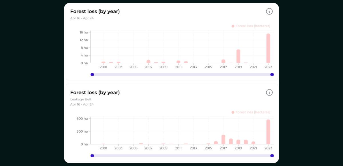
From the validation report of 2024, the following numbers cover both Acacia Shrubland & Woodland Forest:
Project Area Total Deforestation in 2022:
Acacia Shrubland: 230.1 ha
Woodland Forest: 7.0 ha
Leakage Belt Total Deforestation in 2022:
Acacia Shrubland: 386 ha
Woodland Forest: 166 ha
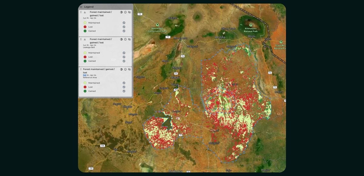
Orbify's analytics rely primarily on the Hansen/GLAD global dataset for detecting and monitoring deforestation. However, the GLAD dataset's methodology, which uses a 5-meter minimum tree height threshold, does not fully capture the distinction between the acacia shrubland and woodland forest strata present in the Makame REDD project area.
The GLAD dataset is designed to provide a consistent, global-scale assessment of tree cover and tree cover loss. While effective at broad-scale mapping, the 5-meter height cutoff means vegetation under this threshold, which may be ecologically important in the local project context, is excluded from the GLAD forest definition.
As a result, Orbify's historical deforestation analysis, which is based on the GLAD dataset, may differ from the more tailored, locally-calibrated satellite imagery classification approach used in the Makame REDD project's validation report from 2024. The project-specific methodology likely provides a more nuanced representation of the project area's vegetation dynamics and deforestation patterns compared to the globally-standardized GLAD data.
This discrepancy can lead to differences between Orbify's deforestation analysis and the project's own monitoring results.
- The Makame project uses a more customized, localized approach to classify forest cover in their specific project area.
- The Hansen/GLAD dataset provides global, standardized tree cover loss data, but may not capture the nuances of the local landscape as well.
Both approaches use Landsat satellite data as the foundation, but the Makame project tailors the methodology to their specific monitoring needs within the project area and leakage belt.
The Makame Savannah REDD project, located in Tanzania, covers a project area of 104,065 hectares and an adjacent leakage belt of 104,015 hectares. These areas feature two main forest types: Acacia-dominated shrubland (MAS) and Acacia-Commiphora woodland (MWF).
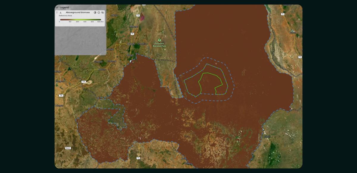
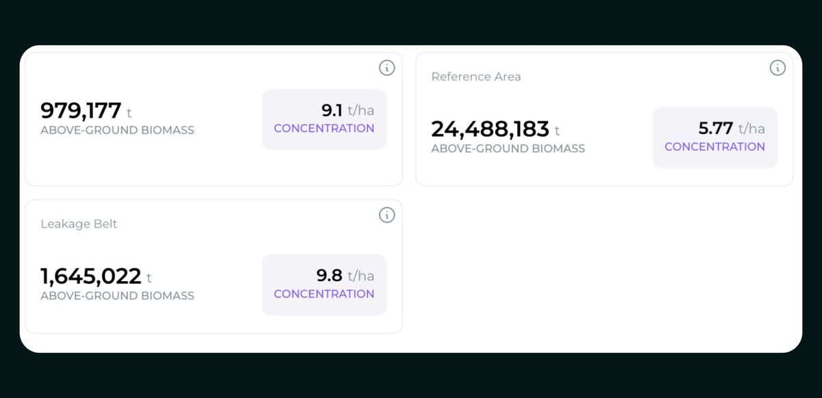
The project report primarily provides carbon stock values (in tCO2e/ha), reporting carbon stocks of 54.6 tCO2e per hectare for the MAS stratum and 99.0 tCO2e per hectare for the MWF stratum. An average above-ground biomass (AGB) figure of 31.0 tonnes of dry matter per hectare is provided for both the project area and leakage belt.
Unlike the project's report, which focuses on carbon stock values, Orbify has developed a method to estimate actual above-ground biomass (AGB) in tonnes per hectare (t/ha) within specific accuracy margins. The statistics below present the AGB concentration per area, offering insights into the AGB distribution as of 2020, with a spatial resolution of 100 meters.
Continuing our analysis, the project description outlines the projected deforestation risks based on annual deforestation rates.
Project Area: The project area covers 104,065 hectares. The document projects a total baseline deforestation of 58,009.9 hectares in this area from 2017 to 2026. The annual deforestation rate is expected to increase over time, starting at 172.5 hectares in 2017 and reaching 8,437 hectares by 2026.
Leakage Belt: The leakage belt encompasses 104,015 hectares. For this area, the projected total deforestation from 2017 to 2026 is 71,800.4 hectares. The annual deforestation in the leakage belt is projected to start at 2,087.3 hectares in 2017 and increase to 9,044.2 hectares by 2026.
Reference Region: The reference region covers a total of 5,011,230 hectares. Based on historical data, the average annual deforestation rate used for projections in this area is 181,035 hectares per year. This larger area is used to model both the rate and spatial pattern of deforestation. It informs the creation of a deforestation risk map, which is then used to predict the spatial distribution of deforestation in the project area and leakage belt.
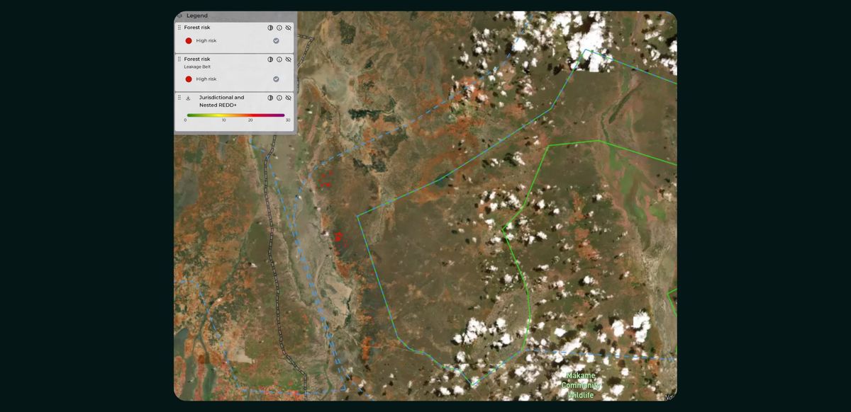
Orbify's assessment for calculating deforestation risk is based on a comprehensive methodology that incorporates multiple risk factors. The Forest Risk score is a composite index built from various elements describing the overall threat to forests. Key factors that contribute to this index include:
- Historical deforestation patterns
- Proximity to cities
- Prevalence of fires
- Areas that have experienced burning
- Proximity to rivers
- Accessibility, elevation, and slope
- Proximity to farmlands
Each of these factors is assessed individually, and their correlation with deforestation is determined through statistical analysis. These correlations are then used to weight the importance of each factor, ensuring that the final index is a balanced representation of all contributing risks. Orbify's approach allows for a nuanced understanding of deforestation risk by considering both direct human factors (like proximity to cities and farmlands) and environmental factors (such as elevation and fire prevalence). This multifaceted approach aims to capture the complex interplay of elements that contribute to deforestation risk.
It's worth noting that while this method provides a comprehensive risk assessment, it may not always predict sudden or unexpected deforestation events, as evidenced by the discrepancy between the predicted low risk and actual significant deforestation in 2023.
The project description outlines a comprehensive biodiversity monitoring plan focused on key indicator species within the project area. The plan primarily targets six mammal species of high conservation value: Giraffe, African Elephant, African Wild Dog, Beisa Oryx, African Lion, and Leopard. These species were chosen as they represent important components of the local ecosystem and are sensitive to habitat changes.
The monitoring strategy employs multiple methods, including ground count surveys, camera trapping, and wet season occupancy surveys. These methods aim to track species presence and absence, relative abundance, and occupancy patterns over time. Additionally, the plan includes monitoring bird species, with particular attention to six threatened and two endemic bird species, though the specific methodologies for bird monitoring are less detailed.
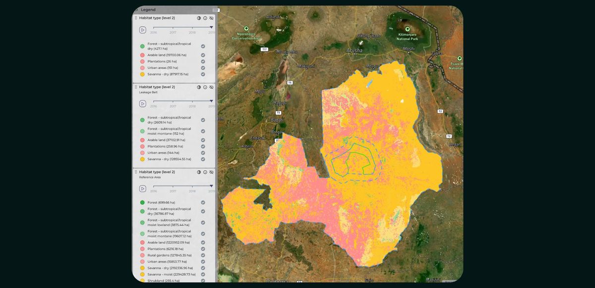
Regarding habitat types, the document describes the project area as primarily composed of Acacia-Commiphora woodland and thickets, interspersed with open grasslands in seasonally flooded areas. This habitat diversity supports both resident and migratory populations of the monitored species. The landscape is characterized by a mix of rocky hills, seasonal swamps, and woodland, creating a mosaic of habitats that contribute to the area's biodiversity.
Orbify's analytics provide a more detailed categorization of land cover types within the project area. These categories include various forest types (such as subtropical/tropical dry and moist lowland forests), savanna (both dry and moist), shrublands, grasslands, and wetlands, among others. For example, the analysis identifies 36,786.87 hectares of subtropical/tropical dry forest and 2,192,336.96 hectares of dry savanna.
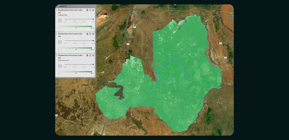
In addition to land cover classification, Orbify offers a measure of biodiversity intactness. This metric quantifies the impact of human activities, particularly land use changes, on species communities. It specifically focuses on how forest changes affect biodiversity integrity. The biodiversity intactness data is available from 2017 to 2020, allowing for the analysis of ecosystem changes over this period.
This comprehensive approach provides a more nuanced understanding of the project area's ecological composition and its changes over time, which can be valuable for conservation planning and monitoring.
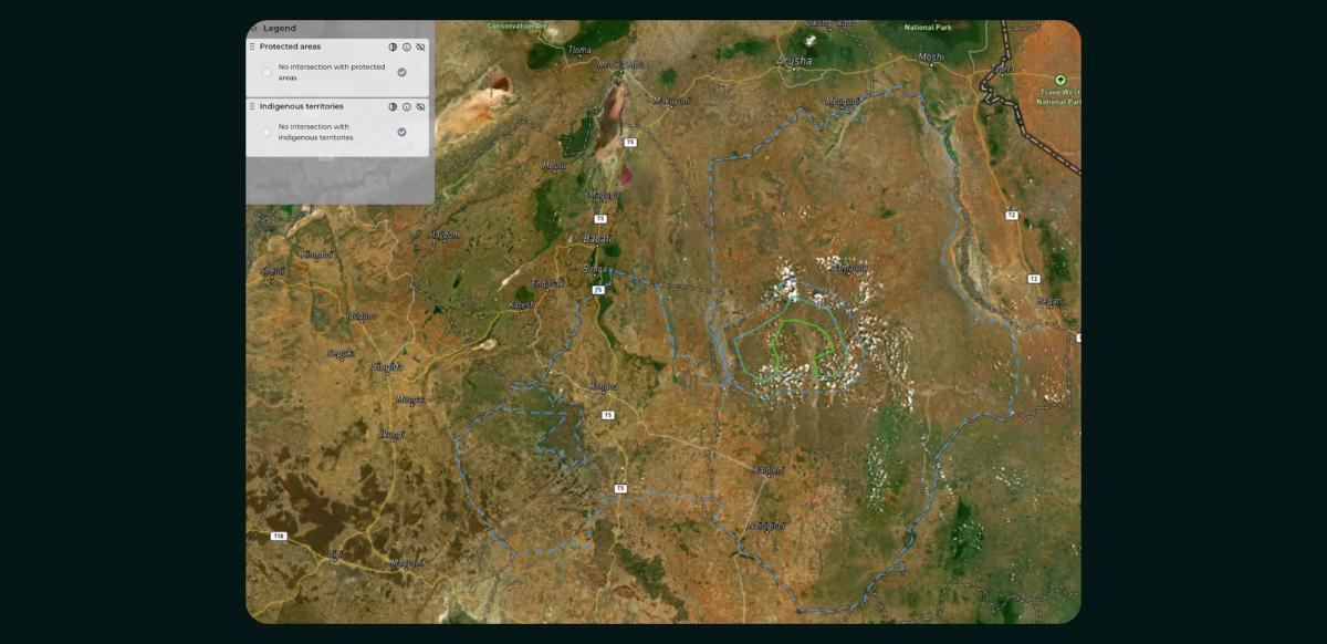
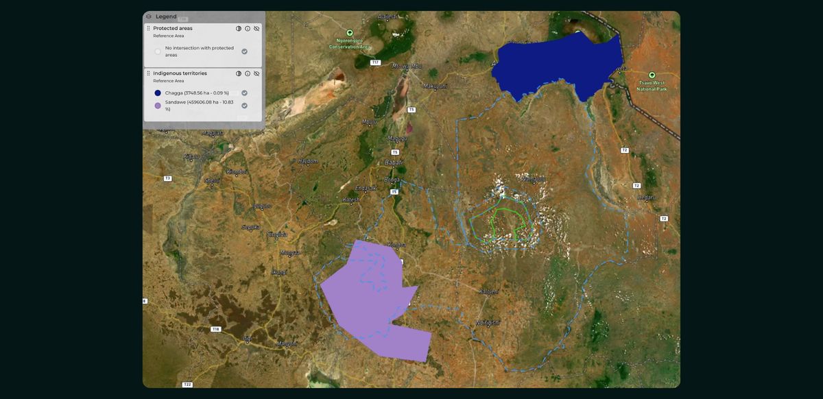
The project description document does not provide specific information about protected and indigenous territories categorized into the reference area, project area, and leakage belt. However, it does mention some relevant information about the project area and its surroundings:
Project Area: The project area is part of the Makame Wildlife Management Area (WMA), which is community-owned land managed by five Masai villages. The WMA was established to allow communities to benefit from wildlife conservation while maintaining their traditional pastoralist lifestyle.
Leakage Belt: There is no specific mention of protected or indigenous territories in the leakage belt.
Reference Area: The document mentions that national parks, forest reserves, and game reserves were excluded from the reference region for location (RRL) as these areas differ from the privately-owned project area.
Orbify's methodology identifies indigenous territories within the reference area but not within the project area. Additionally, our analysis shows that no protected areas are found in either the project or reference areas.
The project description mentions that a climate change and variability analysis using Climate Wizard was conducted to forecast future climate change scenarios. This analysis was projected over the next 50 and 100 years for the northern Tanzania rangelands, including the Makame Wildlife Management Area.
Project Area: The analysis recognizes that climate change poses a major threat and creates uncertainty for the socio-economic and ecological systems in the project area. It highlights that climate change may affect the availability of grazing lands for both pastoralist Masai communities and wildlife.
Leakage Belt: There is no specific climate risk information provided for the leakage belt.
Reference Area: The climate analysis covers a broader area of northern Tanzania, which includes the reference area, but doesn't provide specific details for this zone.
General Climate Impacts: The document notes that climate change impacts may include changes in rainfall patterns and increased frequency of droughts, affecting both pastoral livelihoods and wildlife habitats.
Adaptation Measures: The project aims to improve climate resilience by enhancing governance structures, land and natural resource management through seasonal resource zone planning, and ensuring water availability at the end of the dry season. While the document acknowledges the importance of climate risk and mentions conducting an analysis, it doesn't provide detailed climate risk projections specific to each project zone. The focus is more on general regional impacts and adaptation strategies.
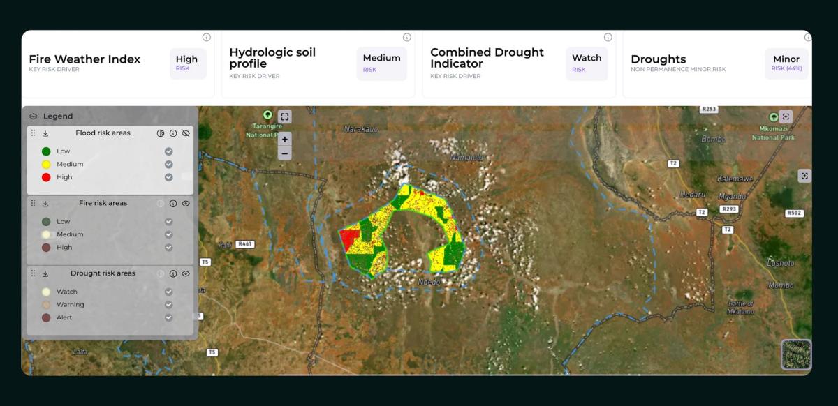
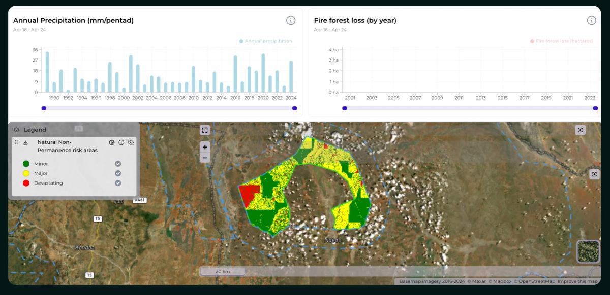
Orbify has developed a sophisticated system capable of calculating risk areas related to floods, fires, and droughts. This risk assessment considers multiple historical meteorological, earth observation, and terrain data to highlight different levels of risk for any given area, identifying which factors play a major role in the outcome. A comprehensive analysis is conducted to calculate the overall risk of non-permanence, providing insights into the project's long-term viability in the face of natural hazards.
If you're looking to ensure the credibility and quality of your carbon projects, our expert team at Orbify is here to help. We use advanced satellite data and rigorous methodologies to provide you with accurate, insightful evaluations.