Last edited: February 12, 2024
Published: February 12, 2024

Orbify
Earth Intelligence Specialists
Blog Post
Last edited: February 12, 2024
Published: February 12, 2024
Orbify
Earth Intelligence Specialists
In the Orbify Review, we pick an NbS project related to the Voluntary Carbon Market from one of the credible registries and review it using our Geospatial Data Platform (GDP) to show how can you use and take advantage of our platform to analyse a VCM project or even to monitor and use the data to include in your PDD on the project development.
For this Review, we've selected The RESEX Rio-Preto Jacunda REDD+ Project located in Rondonia state, Brazil. The project is registered on Verra Registry. The project was selected to be analysed due the fact that it is a famous project usually used by digital monitoring report companies to highlight their capabilities to show the deforestation and monitoring on the area, but we usually see a huge lack of understanding of the real parts of the project and the methodology, so we aim to show that besides providing a full digital MRV (not only the project area as most of the companies do - - they only the project zone - - , we also provide the analysis of the reference area and leakage area, which was extracted by our expeters) we also provide insights of the project as a whole.
The Jacundá REDD+ Project represents a collaborative effort between Biofílica and the inhabitants of the Resex Rio Preto-Jacundá, through the Community Association of the Extractive Reserve Rio Preto-Jacundá and Ribeirinhos do Rio Machado (ASMOREX). The Center of Studies Rioterra (CES Rioterra) and the Executive Board of the Extractive Reserves of the Valley of Anari (CDREX) are also key partners in the planning and implementation of the project's activities.
Situated in the northeastern municipalities of Machadinho D’Oeste and Cujubim in the State of Rondônia, the Resex Rio Preto-Jacundá Protected Area spans over 95,000 hectares. Established in 1996 by State Decree 7,336, this area embodies the resilient struggle of rubber tappers fighting for their rights. The initial occupation began over 70 years ago with the creation of two rubber zones, Jatuarana and Vera Cruz. Following the decline of the rubber industry in the Amazon, these communities became increasingly vulnerable. Today, despite residing in a region rich in biodiversity, the local population faces challenges due to the lack of basic public services.
The project's primary climate goal is to prevent the deforestation of 35,398 hectares, which will avoid the emission of approximately 12,428,713 tons of CO2e. This objective will be pursued through various activities, including political engagement with environmental state agencies, deforestation monitoring via satellite imagery, on-the-ground patrols, strategic physical occupation of the territory, enhancement of forest management practices, and the promotion of the sustainable use of forest products.
The biodiversity aspect, particularly given the presence of an extractive population, is noteworthy. The area is home to threatened and endemic species, such as the white-breasted antbird (Rhegmatorhina hoffmannsi), and lies within the "Endemism Center Rondônia," one of South America's most critical regions for bird endemism. Additionally, the complexity of the Madeira River ecosystem warrants special attention. The project aims to monitor vulnerable species and assess the impact of project interventions, facilitating access for state research and educational institutions to conduct ongoing studies and monitoring of local biodiversity.
Community involvement is integral to the biodiversity initiatives, as the local population derives almost all its income from forest resources, with hunting and fishing being crucial for food security. Research indicates that Resex Rio Preto-Jacundá is in a critical state of deforestation, underscoring the need for prioritized conservation efforts that also support income generation for the community, distinguishing it as an Extractive Reserve.
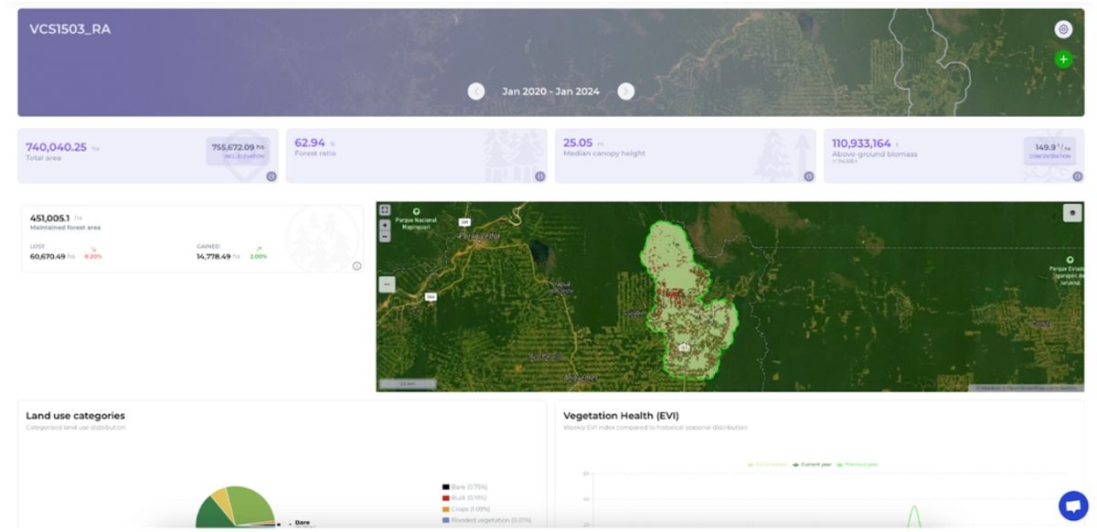
In our review, we will examine the Project, Leakage, and Reference Area as detailed in the PDD documents available on the VERRA website, which were analyzed by our experts. Our goal is not to rate or advise potential investors on whether to invest in this project. Instead, we aim to demonstrate how our platform can be utilized for analyzing projects of interest. For those seeking to learn more about project reviews, please contact us for further information.
We uploaded the project area data to our Geospatial Data Platform and set the timeframe for our analysis, selecting dates from January 1, 2020, to January 1, 2024. This allows us to access the dashboard and view maps featuring various indicators. Through this process, we aim to examine the change analysis derived from the platform for this specific period. Here's what the analysis reveals:
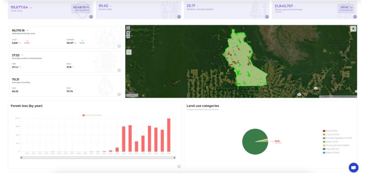
Upon examining the data, we can observe both the extent of forest that has been preserved and the areas affected by deforestation or degradation. Notably, the project area is situated in a region that faces a high threat of deforestation and is currently experiencing significant deforestation. The Hansen chart below illustrates the deforestation occurring within the area.
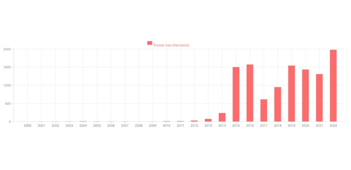
A comparison with the deforestation figures reported by the Project Developer reveals a noticeable trend of increased deforestation, as observed through Orbify data. Intriguingly, since the implementation of the project, approximately 13,000 hectares have been deforested. This is in stark contrast to the initial verification report claims, which stated that only about 150 to 200 hectares were deforested from 2013 to 2015. This discrepancy is evident when compared to the data presented by Hansen et al. in the chart, indicating a significant misalignment.
In analyzing the leakage area, we examined deforestation patterns throughout the project's duration (post-2012) and observed that deforestation has occurred, albeit at rates lower than 150 hectares per year. However, this deforestation was not adequately reported in the monitoring reports nor properly accounted for in the verification reports. This oversight is concerning because such deforestation should be considered and then deducted from the total carbon credits. According to the verification report covering the years 2012 to 2015, deforestation was only reported for the period from 2014 to 2015. Nonetheless, our analysis reveals that deforestation has been occurring in the leakage area since the project's inception, indicating a need for more accurate reporting and verification.
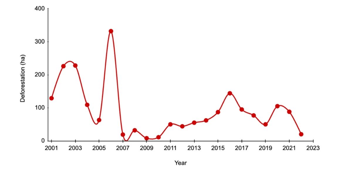
Below, we present a chart for the reference area that illustrates a significant trend of deforestation within the region, highlighting the high-threat status of the project's location. Notably, the project developer chose not to rely solely on the conventional average ratio of deforestation for predicting potential deforestation in the project area. Instead, they adopted a deforestation risk approach, a premium feature available on our platform.
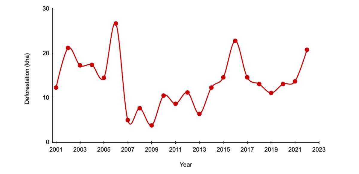
Analysis of the chart and deforestation data reveals that the annual deforestation rate for the reference historical period (2002 - 2012) was approximately 1.78%, exceeding the forest loss projections made by the spatial model, which were based on the deforestation risk map. This discrepancy highlights the potential for both overestimation and underestimation inherent in using the average deforestation ratio approach, thereby underscoring the value of spatial modeling in accurately assessing deforestation risks.
It's important to note that our deforestation risk map utilizes a jurisdictional approach, in alignment with the latest methodology, VM0048, established by VERRA. For additional insights or inquiries, please do not hesitate to contact us.
Our analysis has uncovered significant deforestation within the project area, which appears to have been underreported and inadequately accounted for in the calculation of final carbon credits. Despite the ongoing operation and credit issuance under VERRA, this project shows signs of ineffectiveness in halting deforestation within its bounds. Additionally, we have introduced basic concepts of the VM0015 methodology from VERRA for REDD+ projects, emphasizing the importance of utilizing precise data for accurate emissions avoidance reporting.
This review demonstrates the capability of our geospatial data platform to provide swift and easy access to insights on Nature-based Solutions projects, aiding developers, investors, and government bodies in informed decision-making. Our goal is to highlight the platform's ability to present data objectively, leveraging Earth Observation (EO) data as a critical tool in planning, monitoring, and verifying REDD+ projects. While we abstain from making definitive judgments about the project's overall success, our focus is on showcasing how EO data can be instrumental across all phases of project development.