The Purus Project
Last edited: August 11, 2023
Published: August 3, 2023

Orbify
Earth Intelligence Specialists
Blog Post
Last edited: August 11, 2023
Published: August 3, 2023
Orbify
Earth Intelligence Specialists
In the Orbify Review, we pick an NbS project related to the Voluntary Carbon Market from one of the credible registries and review it using our Geospatial Data Platform (GDP) to show how can you use and take advantage of our platform to analyse a VCM project or even to monitor and use the data to include in your PDD on the project development.
For this Review, we've selected THE PURUS PROJECT located in Acre state, Brazil. The project is registered on Verra Registry.
The Purus Project is a carbon offset initiative developed and registered under the Verified Carbon Standard (VCS) and the Climate, Community, and Biodiversity Standard (CCBS). The project aims to combat deforestation in the region by engaging with local communities and implementing various activities to reduce land and forest resource pressures.
The project development activities involve extensive consultations with local communities surrounding the project area and collaboration with Acre state officials to create a plan for mitigating deforestation. Implementation of the REDD (Reducing Emissions from Deforestation and Forest Degradation) project involves cooperation with local partners and staff. Activities to reduce deforestation include community outreach and education, employment of local community members as forest guards or project staff to replace income from deforestation, agricultural extension training to increase productivity on existing lands, reforestation of non-forest areas, and sharing carbon revenue with communities living on the Moura & Rosa property.
The project involves 18 communities living along the banks of the Purus River, engaging in small-scale farming and ranching, which leads to annual clearing of forests for their livelihoods. The deforestation process includes cutting small trees and vines in the dry season, followed by chainsaw removal of larger trees. Farmers use fire to clear the land, and crops are planted for a year or two before converting the land to pasture.
The Purus Project is undertaken by three proponents: CarbonCo, Carbon Securities, and Moura & Rosa. CarbonCo, a subsidiary of Carbonfund.org, handles project finance and development management. Carbon Securities acts as a liaison between CarbonCo and Moura & Rosa, providing logistical support during site visits. Moura & Rosa, an Acre-based organization created by the landowners, takes responsibility for project activity implementation and day-to-day management.
In conclusion, the Purus Project is an environmentally significant initiative aiming to combat deforestation through collaboration with local communities, governmental bodies, and various stakeholders. By implementing a range of activities and engaging in carbon offset strategies, the project aims to address deforestation pressures in the region, promoting sustainable land use and forest conservation.
In our review, we access the three areas that can be found on the PDD: the Project Area, the Leakage Area, and the Reference Area. We are not considering any potential changes in the area since the first PDD submission, as well as the second baseline assessment. Our aim is not to create ratings or guide the buyer on whether they should invest in that project or not. We will simply show how our platform can be used to analyze the project of interest. If you are interested in project investment consultancy, please contact us.
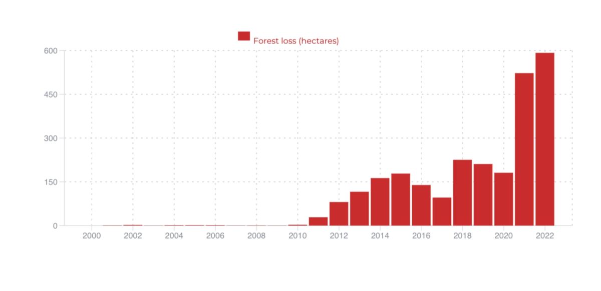
We then uploaded the project area on our GDP and selected the dates of the analysis to cover the data from 2020.01.01 until 2022.12.31. Let's have a look at the change analysis derived from GDP:
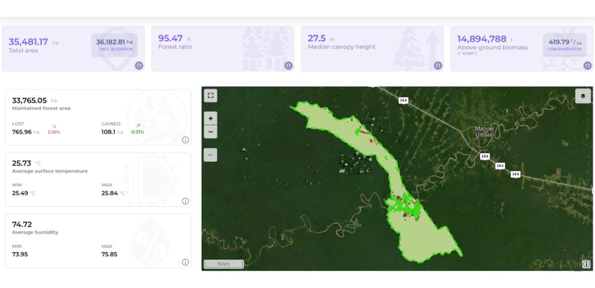
An interesting thing can be noticed following our analysis and using the Hansen dataset. Some deforestation increased in the Project Area from 2011 until today. This does not mean that there was no deforestation before 2011; it happens because the project area only accounts for forested areas. Thus, it is expected that the period before 2011 will show no deforestation as deforested patches are excluded from the project zone, and the project accounting area only includes forested areas. It is important to notice that the last monitoring report presented deforestation on both the Project and Leakage areas for the period of 2018-2020 (the period covered by the monitoring report).
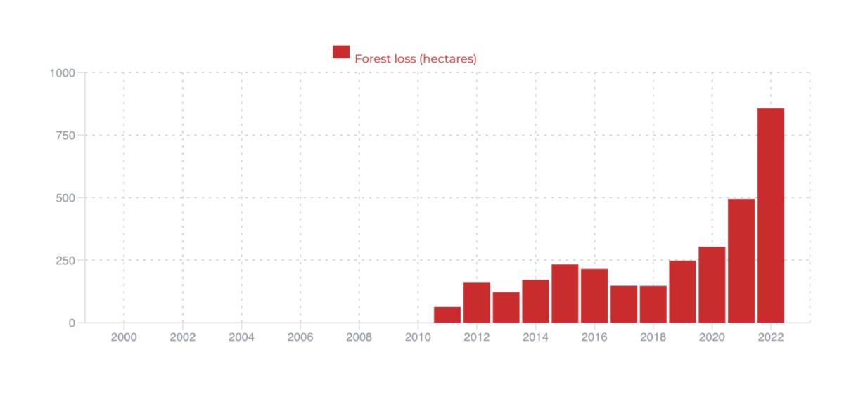
Regarding the leakage area, we also retrieved it from the PDD and ran our analysis on it, as you can see below:
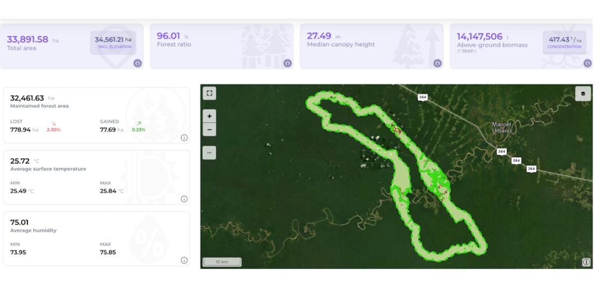
Similarly, deforestation activities started together with the project start date (2011), following the analysis using the Hansen dataset.
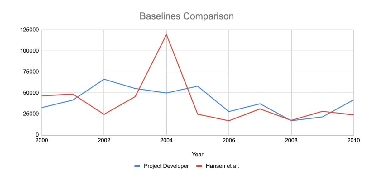
The methodology VM007 requires setting up a Reference Area to calculate the rate of deforestation. We extracted the reference area from the PDD and demonstrated on the chart below the deforestation in the ten years before the project start date compared to what they claimed was deforested and used for their baseline.
The data from the 10 years before the project start date was analyzed and then compared with the data from the Project Developers.
The chart shows that the Project Developers claim an average deforestation rate higher than the one observed by Hansen, which would have a huge impact on the number of issued credits.
In conclusion, we can see that some deforestation was observed in the Project and Leakage areas after the implementation of the project activities. Our app could identify deforestation occurring inside the project area, as well as on the leakage area. Additionally, it showed a lower value of historical deforestation for the baseline when compared with the data provided by the project developer.
The objective of this review is to showcase the power of our geospatial data platform in presenting data objectively. We refrain from drawing any conclusions on the project's success but rather focus on demonstrating how Earth Observation (EO) data can be invaluable in all stages of planning, monitoring, and verifying REDD projects.
We showed how we can use the geospatial data platform to quickly and easily access an NbS project and its historical activities in the area, providing insightful information and assisting in the decision-making process for developers, investors, and government.
Source: Project Description 963