GREEN VALLEY GROUPED REDD+ PROJECT
Last edited: July 10, 2023
Published: May 15, 2023

Maciej Miernecki PhD.
Earth Observation Engineer
Blog Post
Last edited: July 10, 2023
Published: May 15, 2023
Maciej Miernecki PhD.
Earth Observation Engineer
In the Orbify Review, we pick a VCM project from one of the credible registries and review it using our geospatial data platform (GDP) to validate or correct the figures presented in the project’s design documents.
For this Review, we've selected the GREEN VALLEY GROUPED REDD+ Project located in Nova Bandeirantes, in the State of Mato Grosso, Southern Amazon, Brazil. The project is developed by Instituto Ecológica and listed on Verra Registry
VCS Project Type: Agriculture Forestry and Other Land Use
AFOLU Activity: REDD
VCS Methodology: VM0015
Hectares: 10526 Hectares
Project Crediting Period Term: 05/07/2018 - 04/07/2048
Description: The primary objective of the Green Valley Grouped REDD+ Project is to avoid the unplanned deforestation (AUD) of 11,954.69 ha of project area, consisting of 100% Amazon rainforest. Not only does it deliver ecological and carbon benefits, but a portion of the carbon credits generated will also be allocated towards enhancing social and environmental conditions in the project area. Specifically, these credits will support initiatives aimed at strengthening deforestation control, promoting environmental education, and fostering various other social activities.
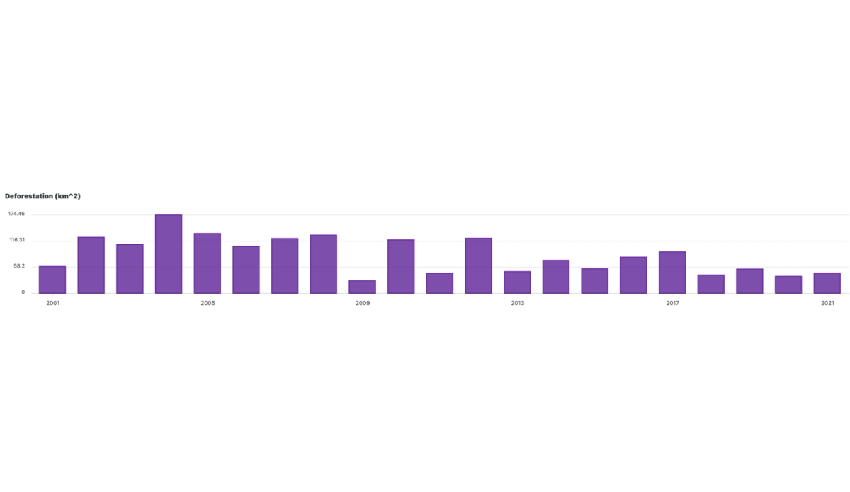
Since the start of the project the deforestation was limited. The during prior 10 years before the project start the average deforestation rate was 87km^2/year. This amounted to an average loss of Above ground biomass of 26.3 kt/year.
Click here to explore the project through Orbify Explorer (our public view access)
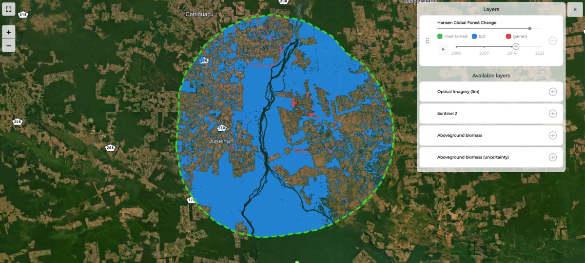
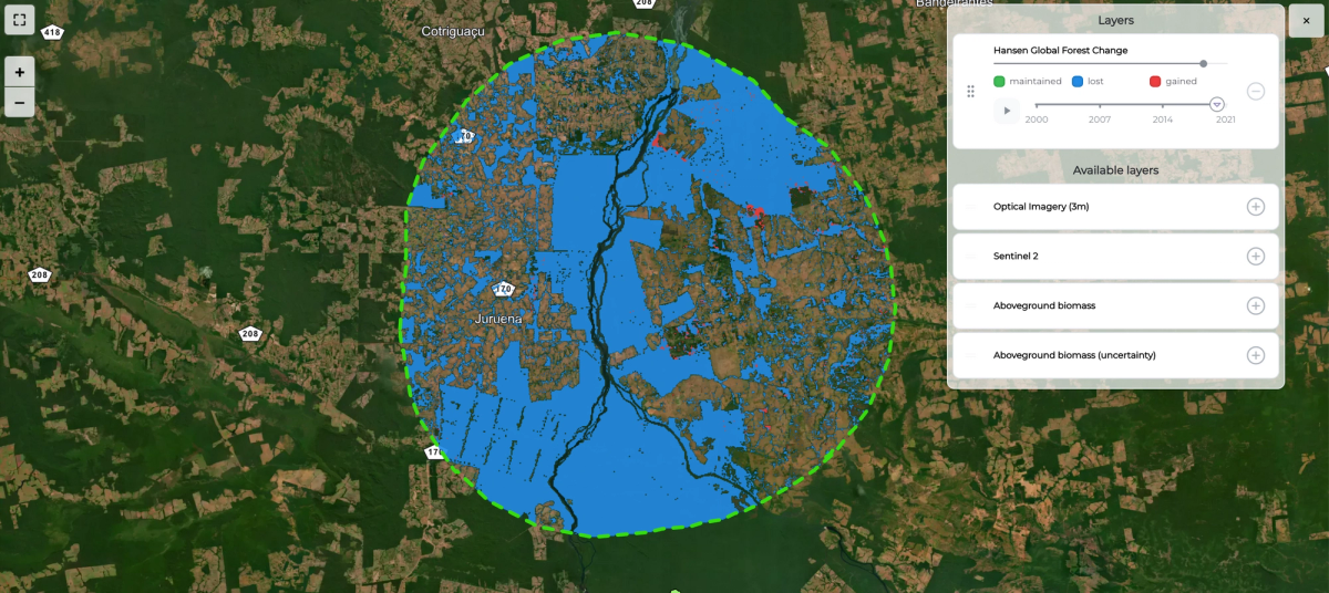
After uploading the shapefile on GDP, we can see the dashboard and map with the indicators.
Period: 1 Jan 2020 - 1 Jan 2023
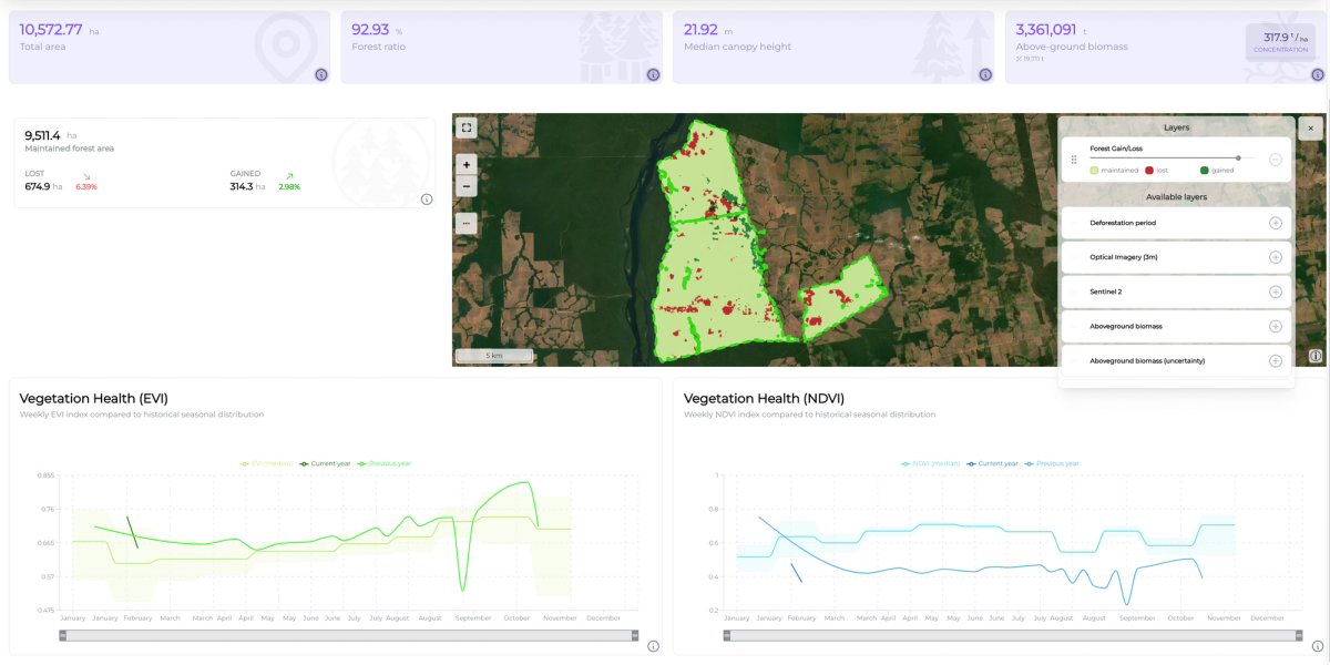
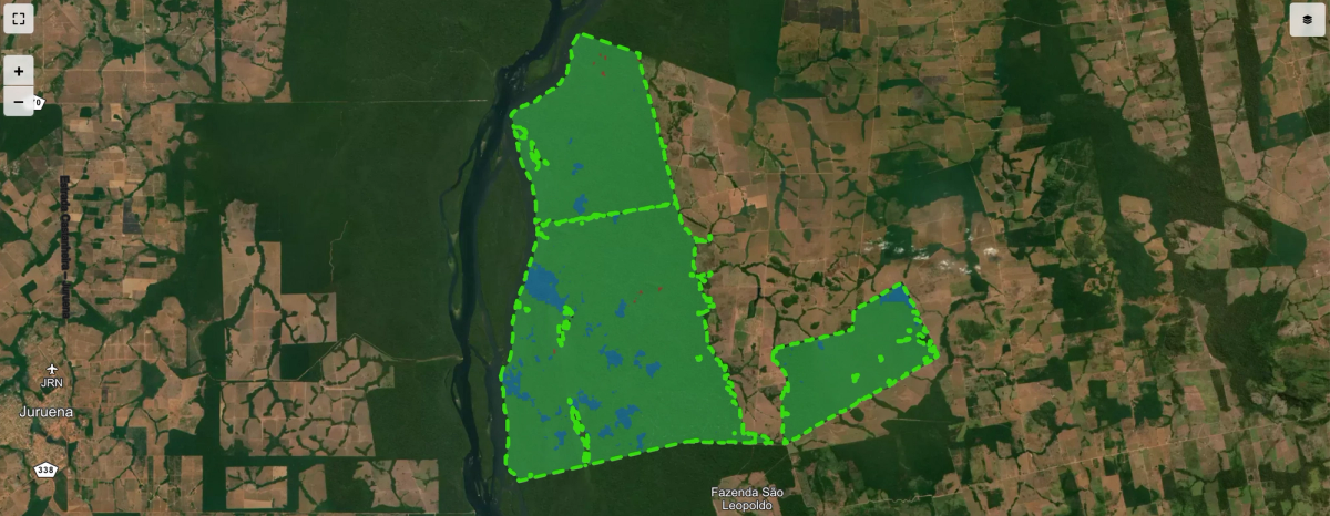
Forest cover remains solid. Since 2020 only a few odd patches had disappeared, whereas whole swaths of the projects had experienced regrowing. In the sustainable forest management plan some logging is permitted provided it does not touch the designed protected areas and does not exceed 7,000 m³/year.
Once we follow the spatial distribution of the deforestation in the period in the ten years before the project start it becomes apparent why this form of protection is crucial for avoiding the encroachment of deforestation into the forest borders.
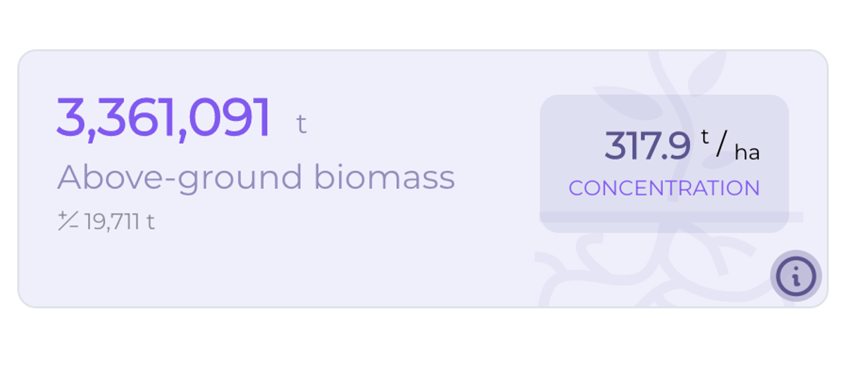
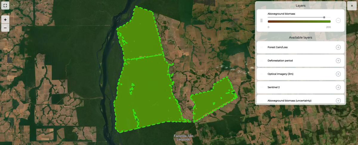
Our estimates confirm that the area of the project has maintained the high Above ground biomass on average 318 t/ha. That corresponds to a healthy non-degraded tropical lush forest.
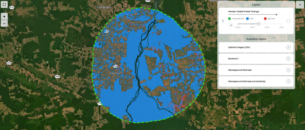
"According to the applied methodology, as no applicable sub-national or national baseline is available, and the country or subnational region has not been divided in spatial units for which deforestation baselines will be developed, a baseline must be developed for a Reference Region. The Reference Region must encompass the project area, the leakage belt and any other geographic area that is relevant to determine the baseline of the Project Area.
A geographic area with agents, drivers and overall deforestation patterns observed during the 10-year period preceding the start date, i.e. November-2010 to November-2020, was determined, representing a credible proxy for possible future deforestation patterns in the project area. The RR (reference region) will be defined in accordance with two criteria:
The latter condition was the most important for adjusting the RR in order for it to more accurately represent the land-use dynamics. Specifically, this was based on the waterways (watersheds) and infrastructure (roads), which are the principal means of human and product transportation in the region. As such, from the areas directly surrounding the project, the RR was expanded to meet the nearest main waterways and roads."
Source: Project Description 2871