Manoa REDD+ Project
Last edited: August 3, 2023
Published: June 12, 2023

Orbify
Earth Intelligence Specialists
In the Orbify Review, we pick a VCM project from one of the credible registries and review it using our geospatial data platform (GDP) to validate or correct the figures presented in the project’s design documents.
PROJECT INFORMATION
For this Review, we've selected the MANOA REDD+ PROJECT located at Manoa Farm, city of Cujubim, state of Rondônia - Brazil. The project is developed by Biofilica Investimentos and Grupo Triângulo, and listed on Verra Registry.
- VCS Project Type: Agriculture Forestry and Other Land Use
- AFOLU Activity: REDD
- VCS Methodology: VM0015
- Hectares: 730387 Hectares
- Project Crediting Period Term: 01/01/2013 - 31/12/2042
- Description: The project is located at Manoa Farm, city of Cujubim, state of Rondônia, in an area of 74,038.7 hectares. The farm’s 73,000 hectares of forest demonstrates the pioneering in sustainable forest management, and is one of the few forest areas remaining in private areas in the region, constantly threatened by invasions and timber theft. Manoa is of paramount importance in the landscape connectivity, as it is close to conservation units and provides shelter for several species.
- Benefits to climate: Avoid the emission of 279,290 tons of CO2e per year or 8,378,697 tons of CO2e along 30 years of the project. This corresponds to 22,118 hectares of avoided deforestation.
- Benefits to the community: With its own low-impact forest management infrastructure, the benefits to the local community and other stakeholders will be focused on training members of local associations and farm employees on issues such as agroforestry systems, low carbon agriculture, sustainable forest management, environmental education, and associativism with a focus on young audiences in the region and small local producers. Another benefit will be the support in the formation of skilled labour to act in the forest and non-timber forest management chain certified, seeking a regional scope for the target public.
- Benefits to biodiversity: Maintenance of forest coverage, preventing deforestation of approximately 23,000 hectares along 30 years of project. Conservation of 177 of flora and more than 360 fauna identified species. Out of these species, 12 are mammals and 9 are birds in some type of threat, according to IUCN. Maintenance of ecological corridors with Conservation Units of the state of Rondônia, reducing negative impacts of the region degradation.
ORBIFY REVIEW
Manoa REDD+ Project is a partnership between Biofílica and Grupo Triângulo, located at Manoa Farm, city of Cujubim, state of Rondônia, in an area of 74.038,7 hectares. Throughout its almost 30 years of history, Manoa has improved its management techniques, becoming a model of worldwide reference of forest exploration allied with the conservation of nature.
The farm's 73,000 hectares of forest demonstrates the pioneering in sustainable forest management, and is one of the few forest areas remaining in private areas in the region, constantly threatened by invasions and timber theft. Manoa is of paramount importance in the landscape connectivity, as it is close to conservation units and provides shelter for several species.
Manoa Project will carry on the following actions to reduce deforestation and consequently reduce emissions:
- Forest protection and monitoring: remote monitoring and in local surveillance, along with the best sustainable forest management practices;
- Scientific research: monitoring of forest management impacts, follow-up and study of identified and/or endemic species, partnerships with educational and research institutions for the production and dissemination of knowledge;
- Local socioeconomic development: through its own training centre, CEFLOM, the project provides trainings and capacitation in techniques aimed at encouraging sustainable development practices such as responsible forest management, agroforestry systems, low carbon agriculture, among others;
- Social empowerment: Strengthening and technical assistance for local producers' associations and environmental education interventions for the surrounding rural population and the municipality of Cujubim, aiming to strengthen small farmers, together with awareness of environmental issues, and consequent improvement in the quality of life of these people.
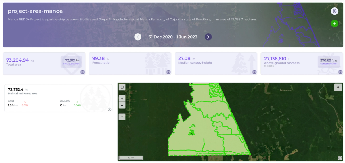
Essential Geospatial Indicators
After uploading the shapefile on GDP and selecting the dates of the analysis we can see the dashboard and map with the indicators. For this particular example we choose the dates to cover the data from 2020.12.31 until 2023.06.01. Lets have look of the change analysis derived with GDP:
- Total area = 73,204.94 ha
- Forest ratio = 98.36%
- Maintained forest = 71,360.7 ha
- Forest loss = 823.6 ha (1.13%)
- Forest gain = 642 ha (0.88 %)
- Median canopy height = 27.08 m
- Above ground biomass = 27,136,610 t
- Average AGB Concentration = 370.69 t/ha
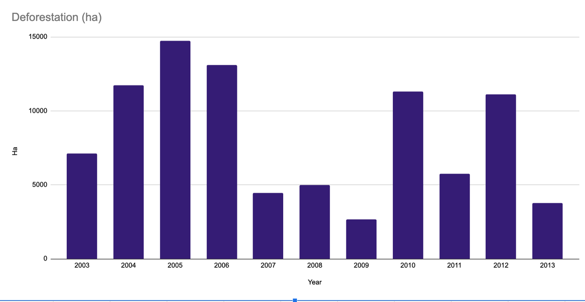
Data for the deforestation in the reference area. We need to show data 2003-2013. 10 years before the project starts.
Reference area in 2005
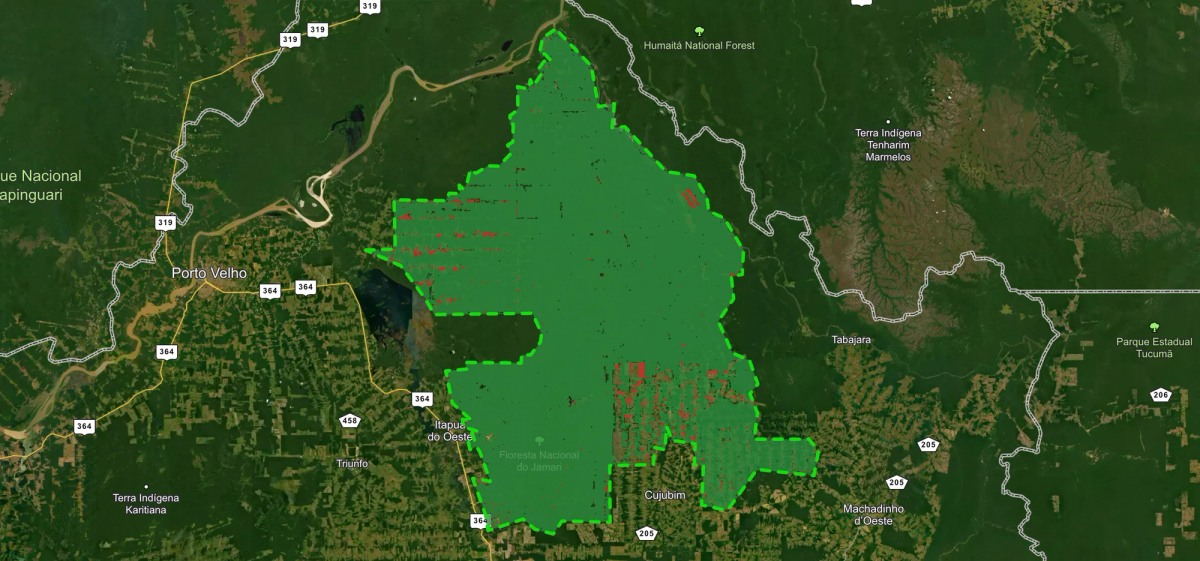
The year 2005 was the one with the highest deforestation during the baseline period(10 years before the project started 2003-2013). A year that saw over 14000 ha of forest disappear. The deforestation in the reference area follows a typical Brazilian pattern: first the access road, is cut, than the side roads branch off and square patches of forest disappear as the incursion progress.
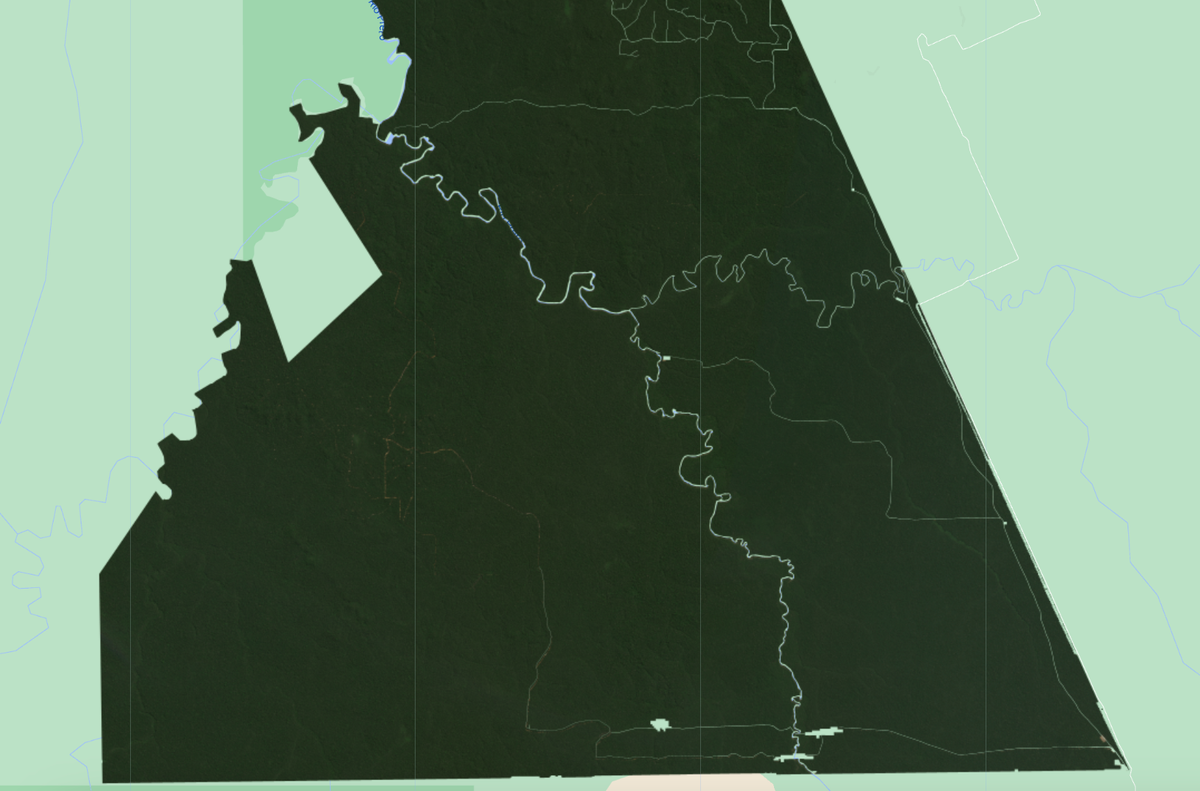
Project Area as of May 2023. Image taken by Planet’s Labs ~3.5 m spatial resolution.
It seems that conservation efforts are successful: no visible deforestation in the region- almost all of the project’s area is covered by forest.
In this review we took a project from Verra's catalogue and using Orbify platform demonstrated how Earth Observation data can help at all stages of planning, monitoring and verification of the REDD project. The EO provides project managers to track the progress of forest management methodologies as well as monitoring the illegal activities that this REDD project is supposed to be mitigating.
Source: Project Description 1571