Last edited: March 14, 2024
Published: March 14, 2024

Orbify
Earth Intelligence Specialists
Blog Post
Last edited: March 14, 2024
Published: March 14, 2024
Orbify
Earth Intelligence Specialists
In Orbify's review, we select a Natural Based Solution (NbS) project related to the Voluntary Carbon Market, sourced from reputable registries. Afterwards, we are using our Geospatial Data Platform (GDP) to demonstrate how our platform can be utilised to analyse a VCM project.
Our approach demonstrates how stakeholders can leverage our geospatial data platform to assess the feasibility and validity of projects. By harnessing geospatial technology and analytics we are ensuring accurate data for carbon project developers. Through our platform, users can make informed decisions for cost-effective, timely, and impactful climate change mitigation strategies.
For this review, we've chosen The Unitor REDD+ Project located in the Amazonas State, Brazil. This project is registered on the Verra Registry. We've selected it for analysis because it's widely recognized within trading circles and has received significant attention, including substantial offers in recent months. It's perceived positively by some individuals, and we aim to evaluate whether it lives up to its reputation.
Our objective is to answer the question: Is this project truly as good as stakeholders suggest?
In this review, we'll leverage geospatial data and satellite imagery to analyse various aspects of the project. However, we will go deeper than only checking the geospatial data. We'll ensure accurate reporting of deforestation occurrences in monitoring reports and verify the alignment of final carbon credits based on satellite data. Additionally, we'll assess the deforestation risk in the area to determine if the project faces significant threats. Furthermore, we'll explore how Orbify's geospatial technology can be deployed to enhance project evaluations, thus contributing to nature-based solutions for climate change mitigation.
The UNITOR REDD Project consists of a total Project Area of 99,035.20 hectares of protected native forests. These forests are located in a region with the fourth highest deforestation rate in the Amazon Biome, specifically in the municipality of Lábrea. Lábrea, situated in the southernmost part of the Brazilian state of Amazonas, is geographically close to the "Arc of Deforestation" and shares borders with other highly deforested municipalities to the South, such as Rio Branco in the State of Acre, and Porto Velho in the State of Rondônia.
Over the historical reference period of the present project (2009 - 2018) in the State of Amazonas, we see a consistent year-on-year increase in deforestation except for 2017 (10% decrease) according to PRODES data: 405 km 2 in 2009 grew to 1,000 km 2 in 2018, representing an overall increase of 147%. The years 2019 and 2020 taken together saw 2,955 km2 of deforestation rates not seen since 1995 1996.
There is furthermore a marked history of illegal land occupation in the project region. The project owners have reported numerous occurrences of illegal land occupation in the project area, during the historical reference period (2009 - 2018). In addition to the police reports registered by the proponents about the attempts of invasion and land grabbing, numerous cases had repercussions in the media. For example, in 2016 two men were arrested on suspicion of invading farms and forcing the owners to vacate their properties to sell them. There are also operations carried out by the Federal Police to investigate criminal organisations that invade lands in the federal public domain to deforest and commercialise illegally harvested wood.
Adding to this scenario of expanding roadways and a history of land grabbing, the high levels of forests which currently cover 92% of the municipality (6.26 million hectares) create an exceptionally high potential for deforestation over the coming years in Lábrea, with a probable future resembling that of the neighbouring States of Acre and Rondônia, to the South, which has undergone intense deforestation historically, mainly due to the expansion of agriculture and cattle ranching.
Within this scenario of intense deforestation pressure, the Unitor REDD+ project’s 15 properties represent 110,944.05 ha total property area which is 89.27% preserved, totalling 99,035.20 ha of forested lands.
In our review, we will access only the Project Area, provided on the VERRA website. Additionally, we will enlist the help of our experts to extract the Leakage and Reference Areas to augment our analysis with more information.
Our aim is not to provide ratings or guide potential investors on whether they should invest in the project. Instead, we will demonstrate how our platform can be utilized to analyze projects of interest. If you require further information or wish to evaluate another carbon project, please don't hesitate to reach out to us. We're here to assist you.
Upon uploading the project area onto our Geospatial Data Platform, we specified the dates for analysis to view the dashboard and map with the indicators. For this particular example, we choose the dates to cover the data from 2020.06.01 until 2023.06.01. Let's have a look at the change analysis derived from GDP. Important to highlight that this project is a grouped project from different landowners, the area that is used in this analysis is considering the registration of the project, which in the second monitoring period stated that 3 areas were excluded which makes a decrease from 99,219.93 ha to 94,270.47 ha. We kept the analysis considering the whole area once the changes in forest land cover were not significant.
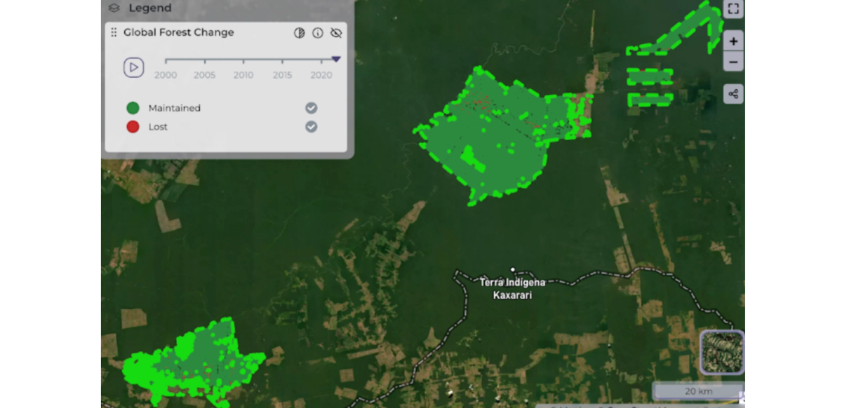
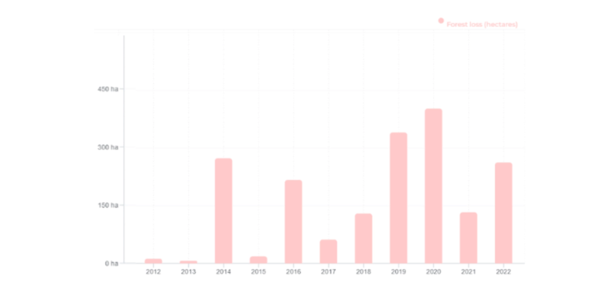
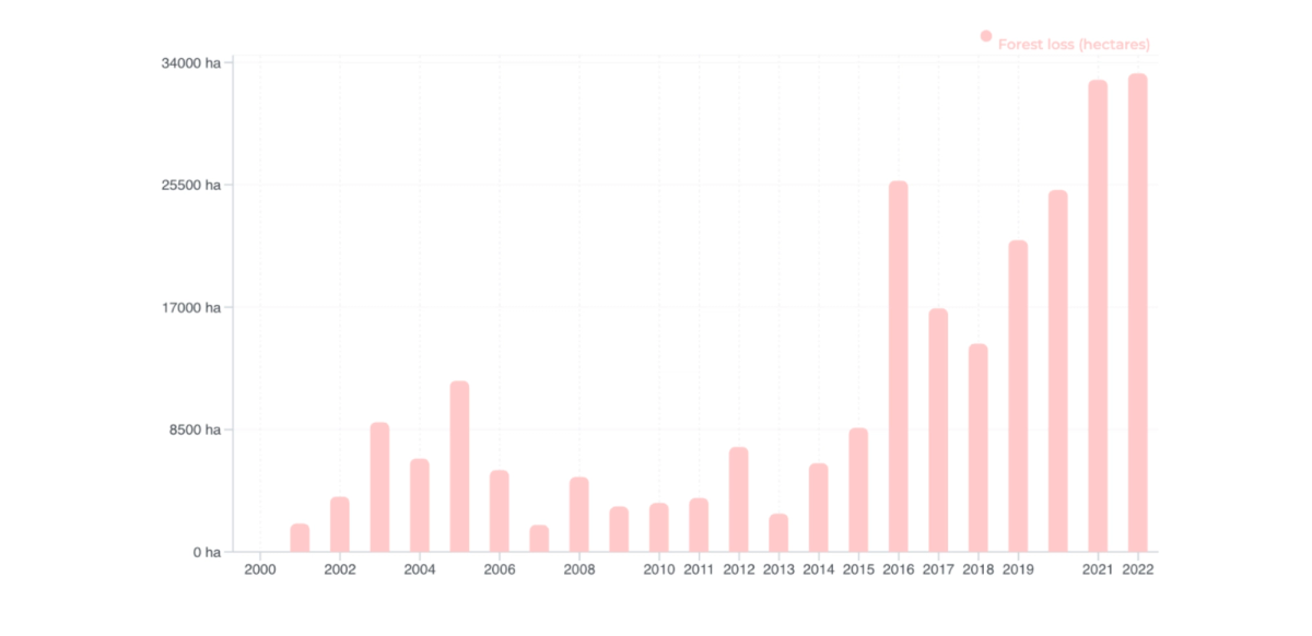
By checking the data it is possible to see the amount of maintained forest and deforestation/ degradation in the area. Interestingly, the area is located in one area of high threat of deforestation and is being quite successful in stopping the clear-cutting inside the area.
It is possible to see on the Hansen chart below some deforestation happening in the area but at a really small intensity. If we look closely we can see that the higher amount of deforestation was around 450ha, which corresponds to >0.5% of the project area, besides that we can see in the image above that the loss in hectares has a different pattern than the common illegal deforestation, being more scattered points around the area, which can indicate the sustainable forest management activity.
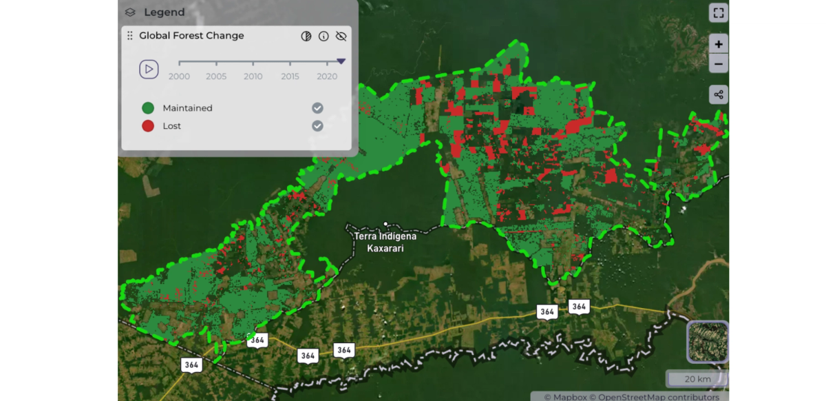
We proceeded to upload the leakage area onto our Geospatial Data Platform and selected the dates for analysis to view the dashboard and map with the indicators. For this particular example, we chose the same dates as selected for the project area analysis. It's important to clarify that we uploaded the entire leakage zone where the leakage area is located. The leakage zone, also referred to as the leakage belt, encompasses the leakage area. The leakage area comprises the forest area excluding all deforestation that occurred until 2018, as highlighted in green in the image below.
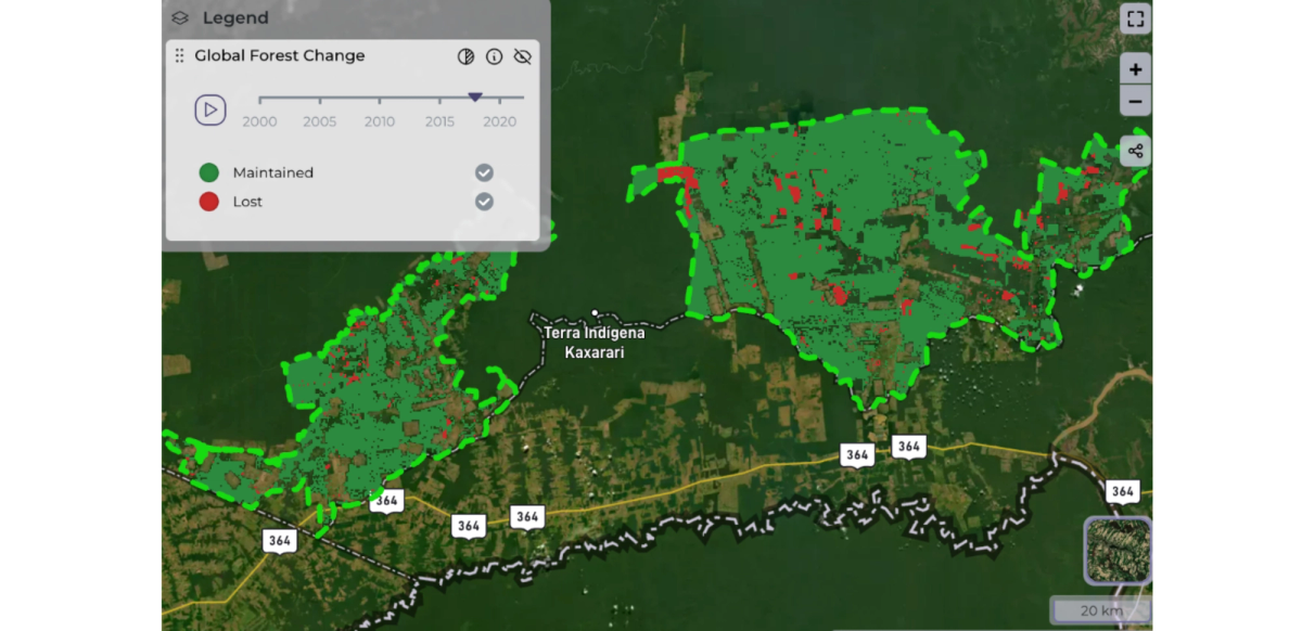
We observed a significant deforestation event occurring within the leakage area, and notably, this deforestation was reported in the monitoring report, which is a positive finding. Our analysis indicates a strong alignment between the reported deforestation and our observations, as depicted in the chart.
This indicates that despite some deforestation occurring within the project area, it was promptly reported and appropriate discounts were applied. However, it's important to note a significant development: an overlap was observed between the leakage belt of this project and the leakage area of a neighbouring project called Fortaleza Ituxi.
This development is not ideal and raises concerns, particularly since the owner of the Fortaleza Ituxi project is also involved in this project. However, we're not here to speculate but to demonstrate the effectiveness of satellite data in project monitoring. Below, you can see the extent to which deforestation activities have impacted the current leakage area.
We proceeded to upload the reference area onto our GDP and selected the dates for analysis to view the dashboard and map with the indicators. For this particular example, we chose the same dates as selected for the project area analysis.
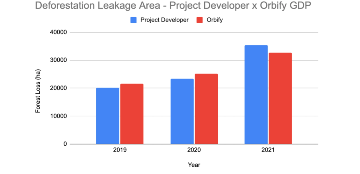
As can be observed, deforestation in the reference area continues to occur at a significant and escalating rate. This alarming trend was also noted by the project developer and reported in the monitoring report.
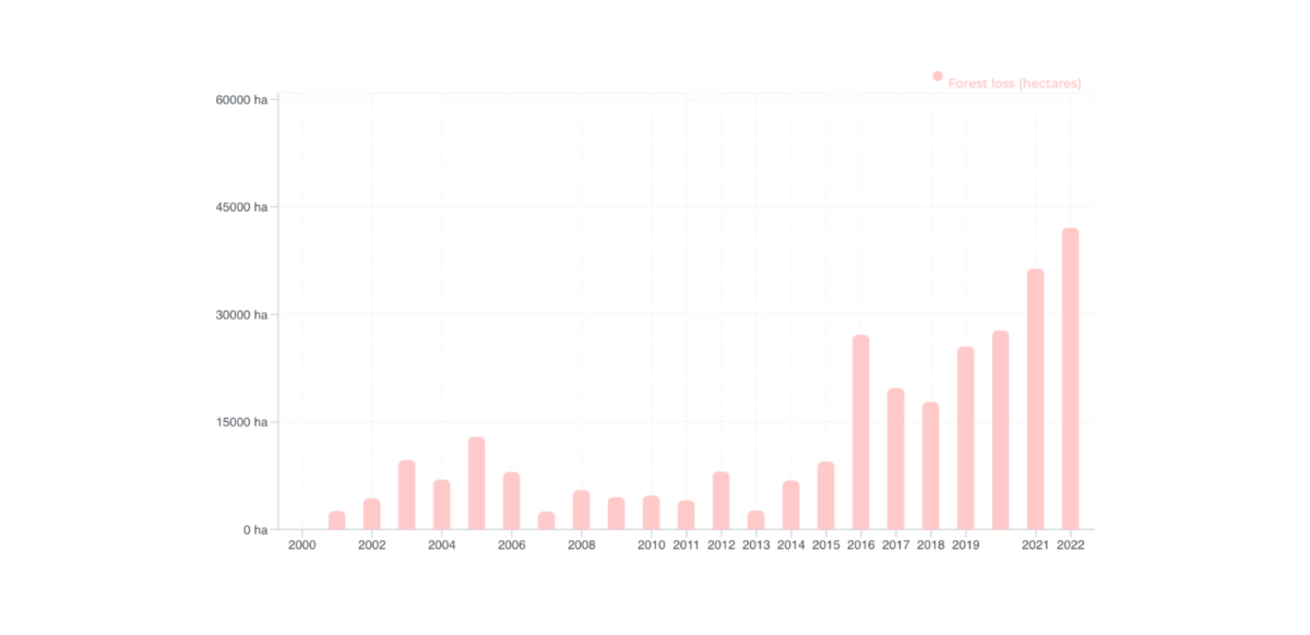
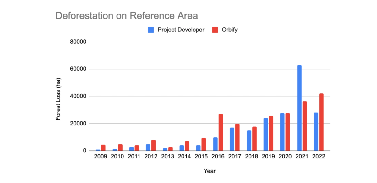
It's interesting to compare the deforestation observed by our analysis with that reported by the project developer. Remarkably, the difference between the two is not significant, indicating that the project developer is not overestimating their deforestation analysis. This alignment reinforces the credibility of their monitoring efforts.
Our thorough investigation uncovered intriguing findings: while some small-scale deforestation within the project area may be linked to sustainable forest management practices, overall, the project effectively curbs deforestation. Additionally, we noted significant deforestation in the Leakage Area, diligently reported by project developers, showcasing their commitment to transparency.
In this review, we showcased how Orbify's user-friendly geospatial data platform provides quick access to NbS projects, offering valuable insights for developers, investors, and government stakeholders. Our goal is to demonstrate the platform's power in presenting data and highlighting the importance of Earth Observation (EO) data in guiding NbS project planning, monitoring, and verification efforts.
What is a Natural Based Solution (NbS) project?
Nature-based solutions are strategies aimed at protecting, managing, or restoring natural ecosystems to address various societal challenges, including climate change, human health, food and water security, and disaster risk reduction. These solutions harness the benefits of natural ecosystems to provide both human well-being and biodiversity benefits in an effective and adaptive manner. Examples include restoring wetlands to mitigate flood risks, conserving mangrove forests to protect coastal communities from storms, and implementing sustainable land management practices to enhance soil fertility and agricultural productivity. These solutions are often community-led and draw from traditional and local knowledge, emphasising inclusivity, transparency, and respect for land rights and local perspectives.
What is the Voluntary Carbon Market?
The voluntary carbon market (VCM) functions as an alternative to the compliance market, allowing companies and individuals to take ownership of their carbon emissions. Participants in the VCM can support climate projects and acquire Verified Emission Reductions (VERs) through trading activities. This form of carbon offsetting adheres to the guidelines established by the United Nations Framework Convention on Climate Change (UNFCCC).
What is a Geospatial Data Platform?
Geospatial Data Platforms (GDPs) are systems that provide a variety of satellite-based environmental insights. Orbify is a leading geospatial data platform that harnesses advanced technologies such as Artificial Intelligence (AI) and Machine Learning (ML) to automate the analysis of satellite imagery. This automation significantly enhances the efficiency of measuring and assessing natural assets, delivering environmental insights with unparalleled speed and accuracy.
What is geospatial data?
Geospatial data encompasses information linked to particular geographic points on the Earth's surface. It typically consists of coordinates and encompasses diverse attributes like land cover, elevation, and infrastructure details. This data is sourced from a variety of outlets, including satellite imagery.
What is satellite imagery?
Satellite imagery refers to visual representations of the Earth's surface taken by satellites orbiting the planet.Through the capture and analysis of data from these sensors, satellite imagery delivers high-definition depictions of the Earth's surface. These images find extensive application across fields such as environmental monitoring, urban planning, agriculture, and disaster management.
What is the feasibility assessment of carbon projects?
A feasibility assessment of carbon projects involves evaluating the technical, financial, and environmental viability of implementing carbon offsetting initiatives. This assessment aims to determine whether proposed projects can effectively reduce carbon emissions and contribute to combating climate change. Key aspects evaluated in a feasibility assessment include the availability of suitable land or resources for project implementation, the feasibility of chosen carbon sequestration or emission reduction methods, the projected costs and potential revenues associated with the project, and the overall environmental impact. Additionally, feasibility assessments may consider regulatory requirements, market demand for carbon credits, and potential risks and challenges that could affect project success
What is a REDD+ Project?
Reducing Emissions from Deforestation and Forest Degradation (REDD+) is an international initiative aimed at mitigating climate change by reducing greenhouse gas emissions from deforestation and forest degradation in developing countries. REDD+ goes beyond deforestation and degradation to include conservation, sustainable management of forests, and enhancement of forest carbon stocks. The initiative provides financial incentives for developing countries to protect and sustainably manage their forests, thereby contributing to global climate change mitigation efforts. REDD+ projects often involve activities such as forest conservation, reforestation, afforestation, and improved forest management practices, with the goal of reducing carbon emissions while promoting sustainable development and biodiversity conservation.
What is the Verra registry?
The Verra Registry serves as the central hub for the implementation of Verra's standards programs. It functions as the primary database housing all relevant information and documentation pertaining to Verra projects and units. By maintaining the registry, Verra ensures the distinctiveness of projects and credits within the system, providing transparency and accountability in the management of carbon offsetting initiatives.