Last edited: September 9, 2024
Published: August 30, 2024

Orbify
Earth Intelligence Specialists
Blog Post
Last edited: September 9, 2024
Published: August 30, 2024
Orbify
Earth Intelligence Specialists
We’re excited to introduce the ARR Existing Projects Template, a robust tool designed to assess and monitor Afforestation, Reforestation, and Revegetation (ARR) projects that have been active for over five years. This template ensures alignment with the VM0047 methodology, offering a thorough evaluation of your project’s impact, risks, and compliance, while streamlining the monitoring process.
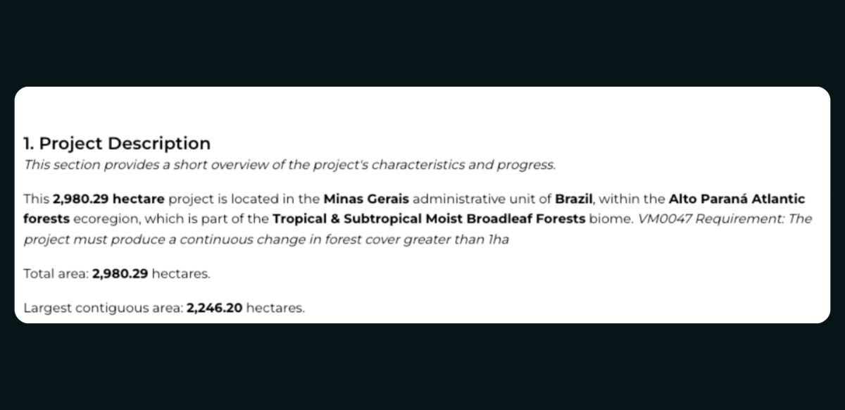
1. Project Overview: The template provides a detailed description of your project, covering essential aspects like location, ecoregion, and total area. It also alerts users if the project might not be suitable for the VM0047 methodology due to plot size, giving you a clear understanding of your project’s scope and helping you identify potential compliance issues early on.
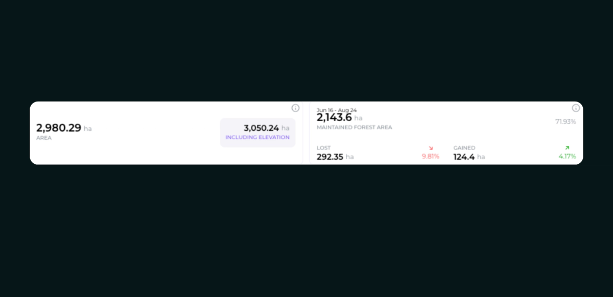
2. Precise Area Calculation: Utilizing Digital Elevation Models (DEM), the template calculates the total area of the project, taking into account terrain slopes to reflect real-world conditions accurately. This ensures that your project’s area is measured precisely, which is crucial for reporting, validation, and making informed decisions based on the actual topography.
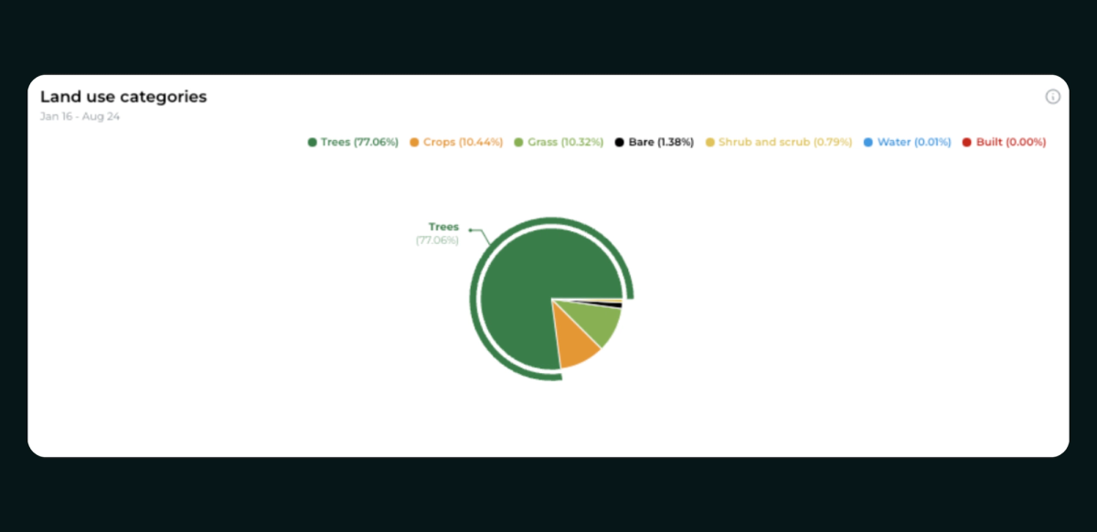
3. Visual Land Use Analysis: The template offers a visual breakdown of land use within the project area through pie charts created with high-resolution Sentinel-2 imagery. This allows you to quickly assess current land cover, identify dominant land use types, and make strategic decisions about land management, ensuring that the project is aligned with its environmental goals.
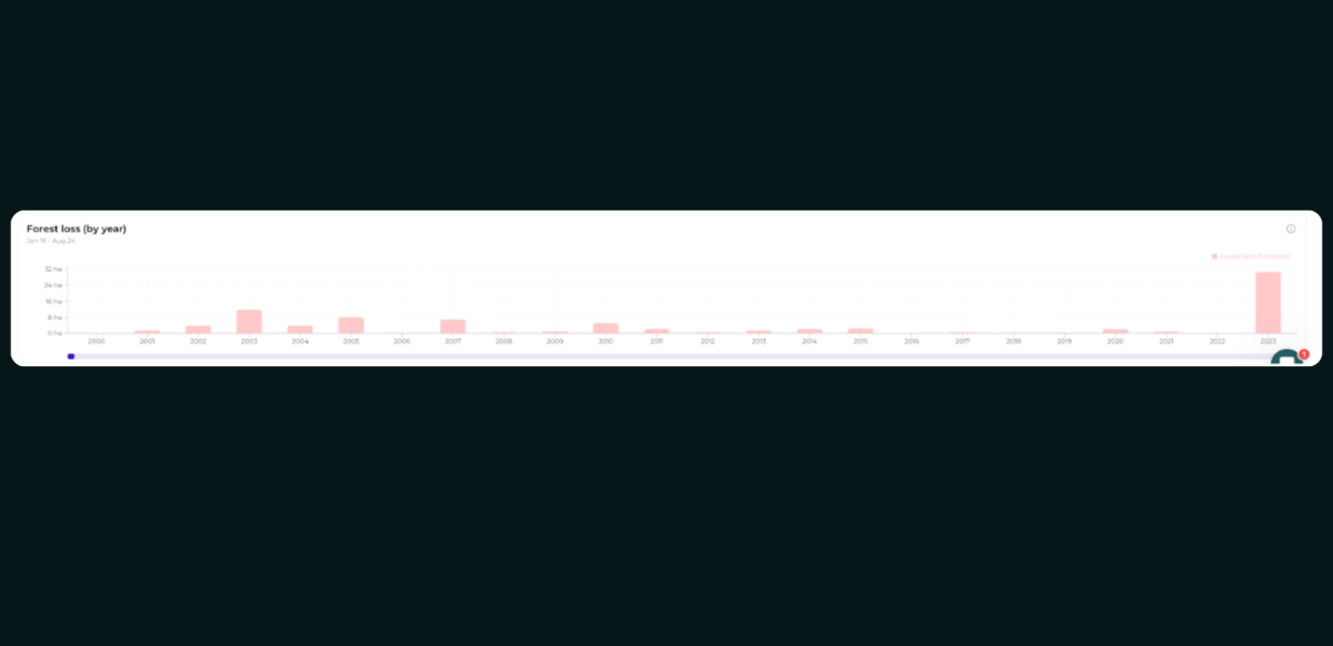
4. Forest Loss Monitoring: The template tracks and quantifies annual forest cover loss using data from the Global Forest Change project. It specifically monitors the transition from forested to non-forested states, helping you understand deforestation trends, assess the impact of human activities, and develop strategies to mitigate environmental degradation.
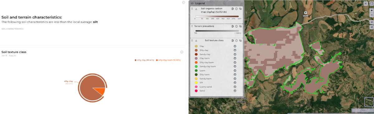
5. Comprehensive Site and Soil Assessment: A detailed assessment of soil and terrain characteristics is provided, comparing the project area with surrounding regions. This includes analysis of soil texture classes based on the USDA classification system, offering insights into soil composition. This information is critical for selecting appropriate species for reforestation and ensuring that the project’s activities are well-suited to the local environment.
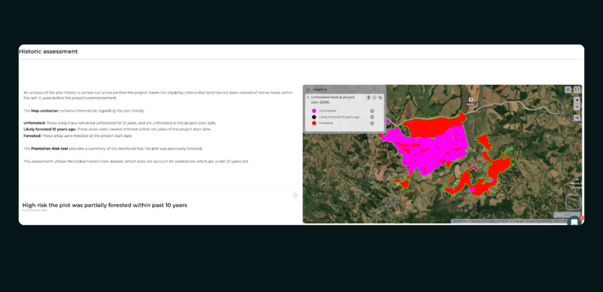
6. Plantation Risk Evaluation: The template assesses the likelihood that the project area was forested within the past 10 years, categorizing this risk as low or high. Understanding historical land use helps you determine the project’s eligibility and additionality, ensuring that the project adheres to the VM0047 methodology and justifies its contribution to carbon sequestration.
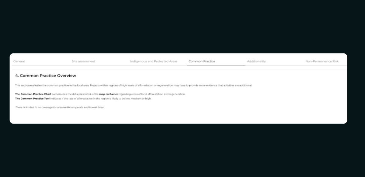
7. Common Practice Analysis: The template evaluates local afforestation, reforestation, and regeneration practices to determine whether your project activities are additional or align with ‘business as usual’ practices. This analysis helps you differentiate your project from common practices in the area, supporting the argument for its additionality, which is crucial for gaining carbon credits and demonstrating the project’s unique impact.
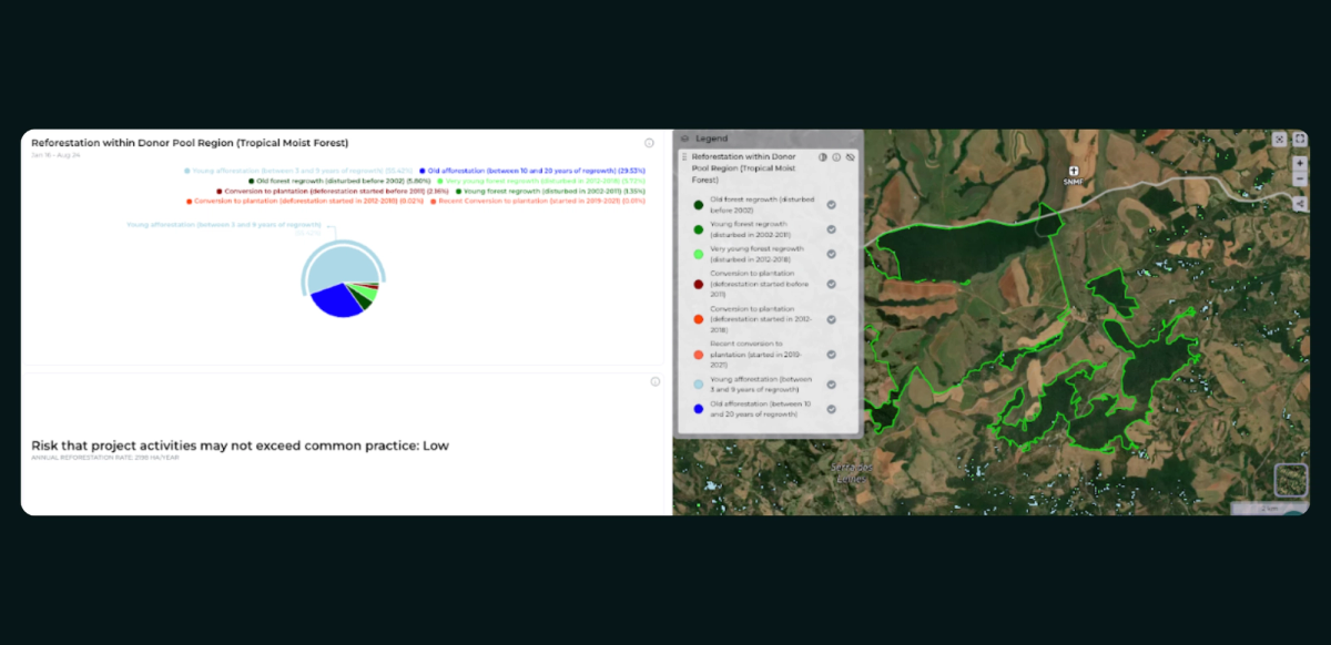
8. Regional Reforestation Visualization: By visualizing forest regrowth in the surrounding region, the template provides insights into local afforestation practices. This includes generating pie charts and maps that show the types and extents of forest regrowth within a buffer region. Such analysis ensures that your project meets reforestation criteria and helps qualify the results of performance benchmarking.
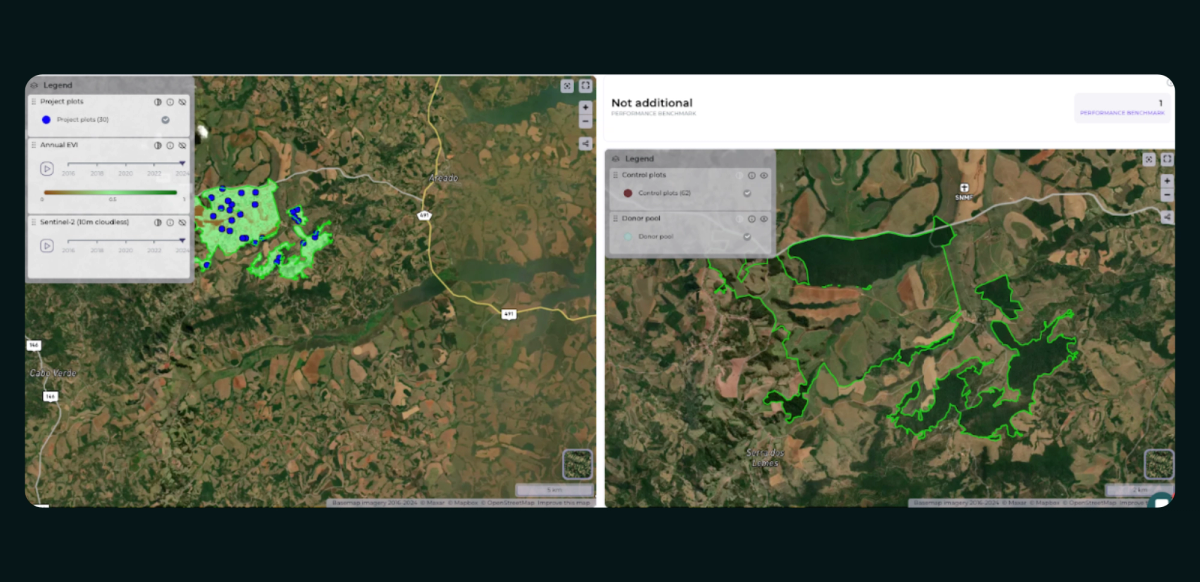
9. Performance Benchmarking: The template tracks the project’s performance over time by comparing project and control plots, using data from 10 to 20 years before the project start date to simulate a performance benchmark. This feature allows you to assess the effectiveness and additionality of your project activities, ensuring that your efforts are making a significant and measurable difference compared to local vegetation changes.
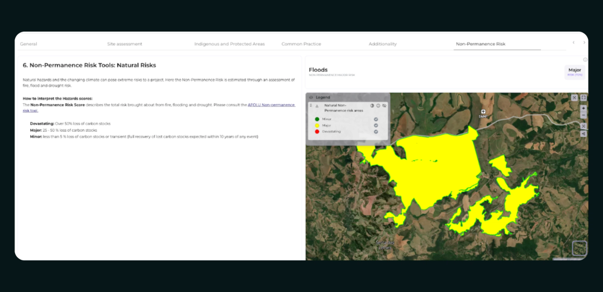
10. Natural Non-Permanence Risk Assessment: The template assesses the potential risks to carbon stocks due to natural hazards like floods, fires, and droughts. It categorizes these risks as minor, major, or devastating based on the likelihood of occurrence and potential impact. By understanding these risks, you can plan for the long-term sustainability of your project, implement measures to protect against natural threats, and ensure that your carbon sequestration efforts remain effective over time.
This comprehensive tool empowers you to monitor, assess, and enhance the impact of your long-term carbon projects, ensuring they are effective, compliant, and capable of making a lasting environmental difference. Whether you’re managing a reforestation initiative in a tropical forest or an afforestation project in a temperate zone, the ARR Existing Projects Template will guide you in achieving your environmental goals with precision and confidence