Leveraging Data for Sustainable Reporting and Analysis
Last edited: July 10, 2023
Published: July 6, 2023

Orbify
Earth Intelligence Specialists
Blog Post
Last edited: July 10, 2023
Published: July 6, 2023
Orbify
Earth Intelligence Specialists
This article is a part of a small series of posts that will be focused on explaining and show case studies about the Geospatial ESG and how you can take advantage of our platform to boost your report and analysis.
First of all, it is important to explain what ESG is for those that are not that familiar. So, Environmental Social Governance (ESG) is the corporate way of turning UN sustainable development goals (SDG) into policies. Policies that corporate entities are trying to include in their quarterly reporting. Although the global consensus on standardization of ESG reporting is still in making with the European Union (EU) ploughing ahead with its directives and the U.S. Securities and Exchange Commission (SEC) is setting similar guidland for companies on how to structure the ESG reporting for the investors and public.
In this blog we will concentrate on the “E” - environmental - part as the geospatial aspect is more pronounced but certainly not limited to this aspect of the ESG.
The Geospatial applications in the environmental monitoring and reporting are probably most established in the extraction industries. Oil, gas, and mining by the nature of their business, as well as long standing legislation on environmental protection have to continuously monitor their assets. Land use changes, water and air pollution, state of the aquifer are all examples of the parameters that have to be monitored either with in situ sensors or via remote sensing techniques with UAVs and satellites. Long time series of remote sensing observations together with an in situ network of sensors allow for construction of data-driven solutions for the industry to better monitor critical infrastructure such as roads, pipelines, power lines and tailing dams. All of the activities associated with the operation of these extraction businesses - the regulator’s argument goes - can influence the surrounding environment and therefore should be included in the ESG reporting so that the customers, investors, and broader public would have a full view of all aspects of running the business.
So far so good but what if the companies that fall under this new ESG reporting scheme are not from the industries that are used to dealing with environmental monitoring? We could list at least three potential solutions:
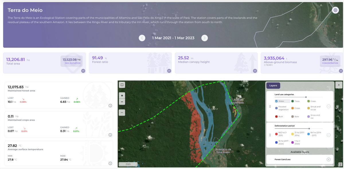
Orbify GDP in action
For the ESG reporting it is extremely important to make the use of all available geospatial data, which can provide additional information in a way that the report will have integrity and quality.
Everything from past and projected deforestation, natural habitat destruction, water table distortion to methane and CO2 emissions will have to be included in the ESG reporting. The obvious problem with this is the verification and cross checking of the declared impacts of the sub-contractors. The solution to that must involve the combination of a publicly available database containing the records from on the ground reports and sensor readings with global-spanning solutions based on satellite data. Such a combination will facilitate the reporting verification process and enable tracing all the leaves of the supply chain.
For instance, let's assume a case of the European deforestation directive - EUDR. The tracking of suppliers and their activities must be verified and cross checked for potential “greenwashing” of their merchandise. The information on the producer, place of origin and volume of cargo should be cross checked in order to prevent double booking and to verify if the production does not involve illegal deforestation activities.
At the global scale a feasible solution would be to employ satellite imagery for the purpose, which can be used to provide information at high temporal resolution and reduce costs of being in the field.
Take the example of a palm oil plantation in the Brazilian state of Pará (2°34’ S, 48°37W):
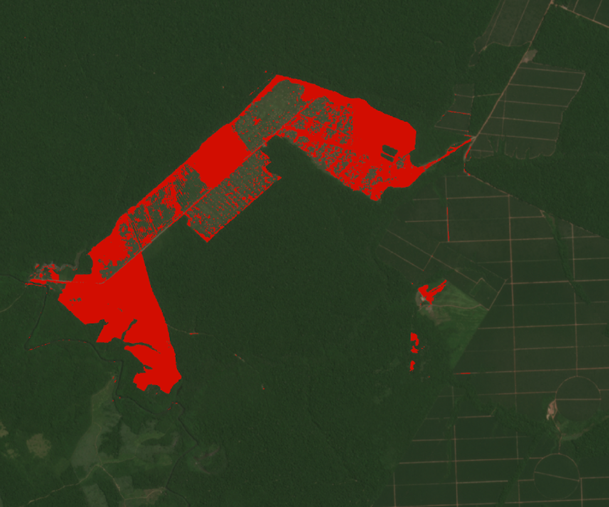
Marked in red is the area deforested from January 2021 (first month of when the EUDR directive had entered into force) until May 2023. The regular grid pattern corresponds to the older plantation plots. Cross-checking the suppliers claims regarding the origin of the commodity we have solid documentation for the environmental reporting for the ESG. As there is a lag between the deforestation and the first harvest of the crop the temporal aspect of the land use verification is a key feature of the geospatial ESG.
Another important way how the geospatial ESG can contribute is the assessment of the indirect implication of the assets on their surroundings. For instance an access road, electrical power line for in a remote location not only serves the asset in question but also contributes to better living standards for the neighbouring communities. Unfortunately, amenities can also facilitate further inclusions into the habitats for third part actors. As the ESG reporting is taking shape it is important to note that some of the indirect consequences of companies business activities could be potentially included.
Taking all the points that was discussed above in consideration, we at Orbify are constantly working and developing new solutions that will make the companies be aligned with the most up to date regulations. Now that you understand better about a overall use of geospatial data to ESG reporting we want to invite you to keep following our posts where we will bring some key case studies by using our plataform to process and analyze the data and to provide insights that can be used by your company on the ESG reports.
To take it a step further we’ve called a webinar on "How to Strengthen the E Pillar in your ESG Reporting with Geospatial Analytics" to approach the emerging application of geospatial data for gaining environmental insights on the asset, corporate, and sovereign levels, specifically focusing on the "E" pillar of ESG reporting. There, you will have the opportunity to explore how geospatial analytics can differentiate environmental performance and support sustainable development goals.
The webinar will take place on Tuesday, July 11th at 4pm CEST, you can save your spot here.