How EarthDefine Transformed Data Visualization with Orbify: A Success Story
This case study explores the collaboration between EarthDefine, a leader in transforming earth sensor data into geospatial information products, and Orbify, whose API solution enabled EarthDefine to visualize and share large volumes of raster data efficiently.
Company Overview: EarthDefine
EarthDefine is dedicated to transforming earth sensor data into consumable geospatial information products for various applications in the private and government sectors. Leveraging advancements in computer vision and Artificial Intelligence (AI), EarthDefine extracts ground cover information from aerial imagery and other sensor data. Their flagship products, the US Tree Map and Land Cover, constitute the largest high-resolution baseline tree canopy and land cover database for the contiguous United States. Additionally, their US Building Footprints data layer maps all structures across the continental United States, providing crucial location intelligence.
The Challenge of Visualizing Large Volumes of Raster Data
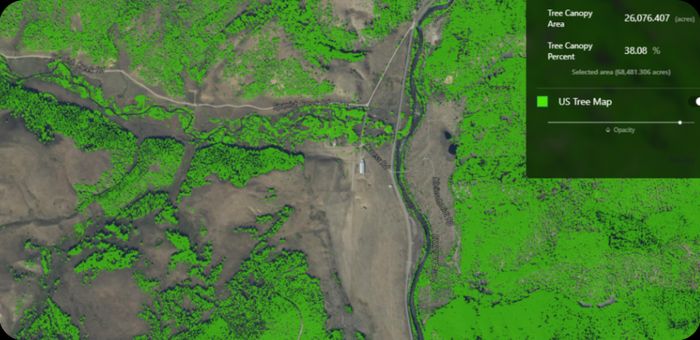
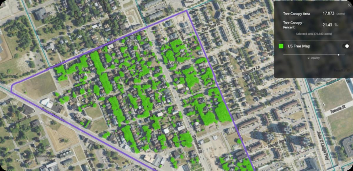
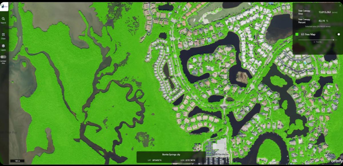
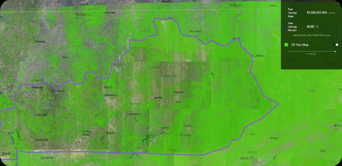
EarthDefine faced a significant challenge in visualizing and sharing large volumes of raster data with partners and clients. The US Tree Map, which represents the most accurate high-resolution tree canopy classification for the continental United States, was particularly problematic. With a 60cm pixel resolution covering over 3.1 million square miles, frequent updates to this dataset compounded the difficulty of maintaining and visualizing the data under one platform. This visualization capability was crucial for their partners in urban forestry to access and utilize the tree canopy data efficiently.
Solution: Orbify’s API Solution
Orbify’s API tool provided the perfect solution for hosting and visualizing EarthDefine's extensive spatial data. The API allowed EarthDefine to display all of their tree canopy data in a single application and update it as needed. Moreover, the solution offered the flexibility to export data portions as web mapping URLs, facilitating easy integration into GIS platforms or software applications.
Enhanced Client Engagement and Market Reach
The ability to visualize the US Tree Map anywhere in the country has been transformative. EarthDefine can now sit with prospective clients and instantly show them their city’s tree canopy data, significantly enhancing their sales pitches and client relationships. This capability has led to new partnerships and recurring projects, particularly in collaboration with PlanIt Geo, an urban forestry software and consulting company. Each new client relationship begins with a demonstration of the data using the Orbify platform, which instil confidence in EarthDefine's offerings.
Future Plans: Strengthening Collaboration with Orbify
In 2023 alone, the US Department of Agriculture awarded over $1 billion in grants to fund community-based urban forestry projects aimed at improving equitable access to trees. Many of these grant recipients lack baseline data to understand the distribution of trees within their communities, highlighting the growing need for reliable tree canopy data.
EarthDefine is witnessing a steady increase in demand for data like the US Tree Map. Their goal remains consistent: to produce up-to-date, accurate tree canopy data. They will continue collaborating with their partners at PlanIt Geo to deliver consumable canopy data and analytics to their clients as they address their urban forestry needs. The Orbify platform will remain central to client development in the early stages.
Currently, EarthDefine is working with a US federal agency and a major non-profit organization to provide land cover, tree canopy, and canopy change data to all urban areas within the US, US Territories, and Protectorates. Establishing baseline land cover and canopy data in these regions is a significant task that will support both current and future urban forestry projects and help guide grant funding. They are collaborating with Orbify to host this data and create GIS-ready layers. This initiative marks the first time their land cover and tree canopy data will be readily accessible to the public.
The impact of data visualization on the interpretation of and confidence in EarthDefine's data products cannot be understated. Their collaboration with Orbify will continue to grow as they tackle new challenges and seek innovative ways to deliver data to their clients.
“There is an inherent visual element to our data products, so our goal has been to find a way to bring this aspect to the forefront of client development. We’ve realized these goals by working with Orbify. Their experienced team has developed a streamlined data pipeline to ingest our products and bring big data visualization straight to our end users. Now, we can share our nationwide data products, the cornerstones of our business, with a sharp-looking, easy-to-use application. We couldn’t be happier with the outcome.” - Taylor McDowell Geospatial Project Manager at EarthDefine


