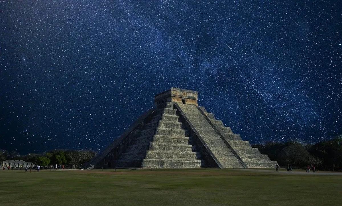
In recent times, every one of us has had the chance to run across articles writing about incredible archaeological discoveries made by remotely sensed engines that have allowed detecting tombs, roads, even cities that were “invisible” instead. However, for those who work in this field (i.e. archaeologists), it is not a surprise to use airborne engines for studying archaeological sites from the air. Archaeologists have always been taking advantage of airborne technology, adapting it to their scopes for capturing details and, sometimes, entire new archaeological patterns, such as buildings, cities and landscapes.
Satellite images (and high-resolution imagery) make no exception to this use. From ground view to aerial view. As a field discipline, archaeology is a focused field that researches imperceptible historical information of artifacts
and objects, digging into mud and sand. But, sometimes, a wider point of view is needed, especially when the study subject is related to topographical issues. In cases like this, a ground point of view is not enough, even if the area is covered by several surveys. Only from above, soil anomalies, subtle topographic details, singular compounds, and unusual marks can be detected and, like the pieces of a puzzle, connected for displaying the history of that area. Since the end of the XIX century, archaeologists have been launched balloons, airships, plans, etc. to take pictures of odd ground elements and use aerial images to see the big picture of entire already known archaeological places, or, even better, to detect hidden sites revealed by soil traces and
shadows, and then map them.
As the aerial perspective is a key factor in the archaeological field, the advent of satellite images for earth observation (as well as other airborne technologies, like LiDAR or UAV) has inevitably opened new and unexpected perspectives.
Why and how Earth observation serves archaeology?
A large extent of areas is taken in one snapshot, the capability to picture the most inaccessible places of the Earth in different wavelength bands, and non-invasive investigation.
Here are some of the qualities that have driven the success of the Earth Observation (EO) imageries in archaeology: From the late of the 70’s, satellite images have caught on in archaeological science and have contributed to: discovering astonishing and complex archaeological features, like ancient rivers, settlement arrays, tombs, cities, mapping isolated sites, where ground surveys were and are not always possible, invaluable supporting the monitoring of sites’ status of conflicted areas too, where war and looting threaten the cultural heritage, as in Iraq and Syria.
However, how EO does exactly work for archaeology?
Alike aerial photos, satellite optical images help to detect hidden features, like vegetation or soil marks.
These anomalies result from buried structures or ditches, which affect the overlying soil or vegetation texture and appear as an atypical crop growth or unexpected soil color. Sometimes they emerge in conventional photographs clearly, other times, they are too soft and request a more accurate observation, which could be performed only by inquiring about each part of the wavelengths supplied by optical satellite images. The variation of the crop growth, as well as the difference in soil moisture, is well detected by the red and infrared bands. Advanced calculations (like the one performed by the NDVI, normalized differential vegetation index) enhance traces that could be imperceptible to the naked eye. Landsat images have done their entrance into the archaeological research since their early missions and, as long as the ground resolution has been increased, high-resolution imageries have become essential.
Synthetic Aperture Radar (SAR) satellite data are not set aside in this context. their ground penetration has already contributed to determining the presence of buried archaeological relics beneath dried soil in Egypt and Perú. Polarimetric, weather-free capturing mode, frequency, and multi-incidence are elements that are still analyzed by archaeologists to entirely exploit the SAR satellite data potentials.
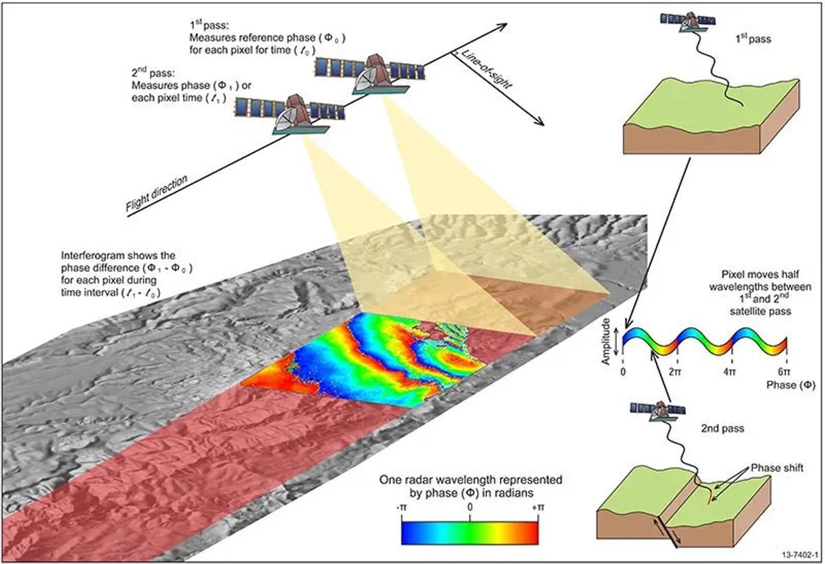
Interferometric Synthetic Aperture Radar | Geoscience Australia
High-quality imagery is also fundamental too for the archaeological feature detection and creation of other suitable geospatial elaborations provided by satellite images. Archaeologists benefit from the digital elevation models (DEMs) generated from stereo satellite images by creating high-resolution 3D visualizations and locating micro-topography, allow to understand ancient urban planning and offering more comprehensible and catch-eye representations.
Earth Observation means not only detection and mapping for archaeologists. Political crisis, wars, dramatic urban and touristic development, and climate change events have imposed to use of satellite images for actively monitoring the cultural heritage and providing up-to-date information about the hazards it is facing. Conflicts in Iraq, Syria, Yemen, and Nepal have requested a consistent assessment equipped with high-resolution images of the damages and looting monitoring and preventing illicit traffic of archaeological objects. Temporal resolution (distance time a satellite needs to take two images of the same area) is crucial for monitoring, and the set of open-source imagery, provided by Satellite Constellation (Sentinel 1 and 2) of the Copernicus project, allows to accomplish this task and help local communities in addressing better solution for the preservation of their archaeological cultural heritage.
EO and archaeology: an everlasting relationship
The multifaceted use archaeology does of Earth observation data induces us to ask: where do archaeologists find time to analyze this huge amount of data?
The “big data era” and the continuously increasing number of satellite images collected (as well as the increasing extent of the km2 analyzed) are obviously influencing the archaeologists, who are adopting new advanced strategies to get out the most from EO images.
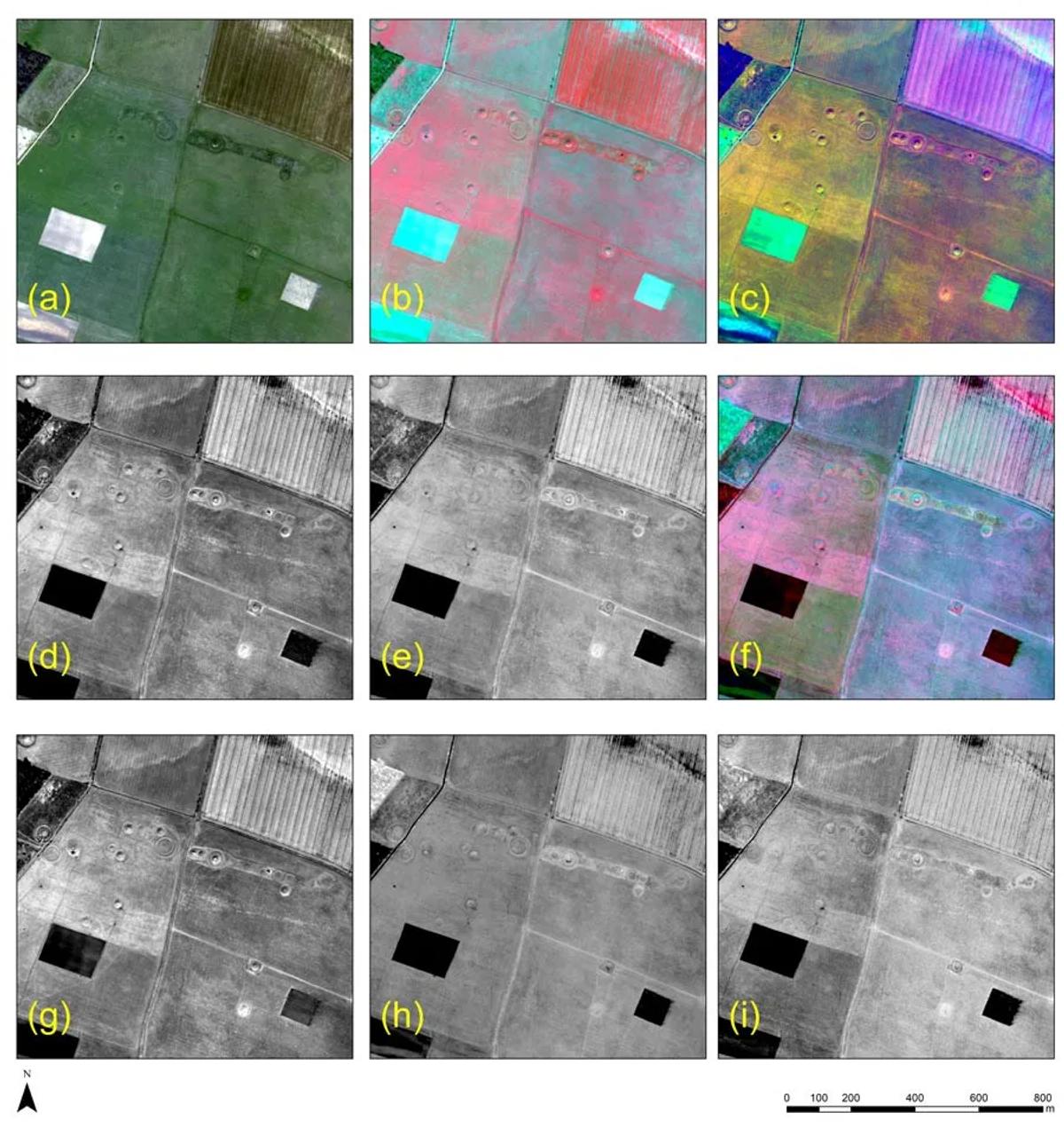
The prehistoric landscape of Stonehenge as recorded from WorkdView-2. (a) Red-Green-Blue (RGB) composite; (b) Near-Infrared — Red — Green (NIR-R-G) composite; © Principal Component Analysis (PC1-PC3) composite; (d) first principal component; (e) Normalized Difference Vegetation Index (NDVI); (f) Vegetation — Soil — Crop marks components composite; (g) vegetation component; (h) soil component and (i) crop component. -Source: https://researchoutreach.org/articles/archaeology-space-using-earth-observation-data-unearth-past/
Artificial intelligence, satellite images machine learning-based classification, advanced data fusion, and data policy management are becoming the most tendencies research topics in archaeological research. If in the past the trained eye of an (or more) archaeologist entrusted the detection of mounds, roads, and tombs, now, the same archaeologists, train algorithms to automate the search of these archaeological features in multi-sensored and
multi-temporal images.
The results of these studies are still under process and calibration, but they will surely amaze us once again, surprising us with spectacular and mind-blowing archaeological discoveries.