Last edited: September 6, 2023
Published: September 5, 2023

Orbify
Earth Intelligence Specialists
Blog Post
Last edited: September 6, 2023
Published: September 5, 2023
Orbify
Earth Intelligence Specialists
The global issue of deforestation has prompted the development of various mechanisms to counteract forest carbon loss and promote conservation efforts. One such framework, the Reduction of Emissions from Deforestation and Forest Degradation (REDD+), aims to incentivize tropical forest countries to curb deforestation and its associated emissions. However, a challenge remains in the form of deforestation leakage, where policies and projects designed to protect forests inadvertently lead to a shift of deforestation to other regions. This article delves into the role of satellite Earth observation technology in addressing this leakage phenomenon and advocates for an integrated management approach. By analyzing the extent of deforestation and monitoring its spatial patterns, satellite data offers insights crucial for effective policy implementation, cross-border collaboration, and the establishment of comprehensive jurisdictional programs.
The global concern for mitigating climate change has spurred efforts to combat deforestation, recognizing the vital role of forests in sequestering carbon dioxide. The REDD+ framework was established to facilitate tropical forest nations in their endeavors to reduce deforestation and maintain forest health. However, the challenge of deforestation leakage persists, demanding innovative solutions that span multiple governance levels and geographies.
Deforestation leakage occurs when efforts to curtail deforestation in a specific area lead to a displacement of these activities to other regions. This phenomenon challenges the effectiveness of localized conservation projects and necessitates a broader perspective in policy design. National-level policies, while comprehensive, fail to account for international leakage effects, further complicating the attribution of deforestation drivers.
Satellite-based Earth observation technology has revolutionized the monitoring of global environmental changes. High-resolution imagery, combined with advanced remote sensing techniques, empowers researchers and policymakers to detect and quantify deforestation with unprecedented accuracy. The ability to identify changes in forest cover, assess land-use alterations, and track deforestation dynamics over time is invaluable for understanding the drivers of leakage.
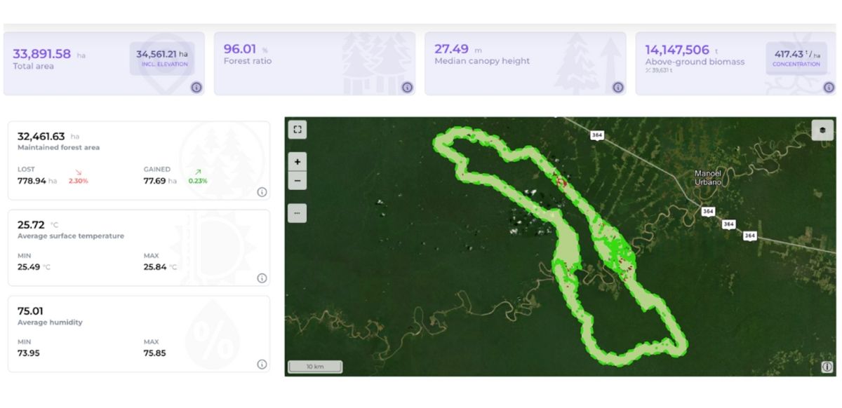
Leakage analysis through Orbify Geospatial Data Platform. Learn more about this feature
At the heart of mitigating deforestation leakage is the comprehensive utilization of satellite data. By employing these data sources, policymakers gain insights into spatial patterns of deforestation, enabling them to identify areas at risk of leakage. Such information facilitates the design of interventions that account for potential spill-over effects, thus ensuring that localized policies do not inadvertently exacerbate the issue.
The Amazon Rainforest spans multiple countries, each with distinct policies and development agendas. Historically, efforts to combat deforestation in one region have led to unintended deforestation leakage in neighboring areas. For instance, strict conservation policies in one country might incentivize illegal logging and land conversion in an adjacent nation with weaker regulations. This phenomenon highlights the complexities of deforestation leakage and underscores the need for an integrated approach.
Satellite technology has played a pivotal role in tracking and understanding deforestation dynamics in the Amazon. Organizations like the Brazilian National Institute for Space Research (INPE) utilize satellite imagery to monitor changes in forest cover. High-resolution satellite data provides real-time information on deforestation patterns, enabling authorities to identify areas at risk of leakage. The Real-time Deforestation Detection System (DETER), developed by INPE, uses satellite imagery to detect deforestation events as they occur. This timely information empowers law enforcement agencies and policymakers to take immediate action against illegal activities.
The Rio Anapu-Pacaja REDD Project located in the state of Para, Brazil, is characterized by its rich biodiversity and significant carbon storage capacity. The project, implemented by the Brazil AgFor LLC, seeks to curtail deforestation and degradation while simultaneously promoting sustainable livelihoods for local communities.
One of the key strengths of the project is its community-centered approach, mainly the ones that lives around the riverline, know as "ribeirinhos". Local communities are integral stakeholders in the project's design, implementation, and monitoring. By engaging communities in decision-making processes and providing alternative income opportunities such as agroforestry and sustainable non-timber forest product extraction, the project aims to reduce pressures on the forest and prevent leakage due to displacement of deforestation activities.
Since its inception, the Rio Anapu-Pacaja REDD Project has demonstrated impressive results in terms of deforestation reduction and leakage mitigation. By engaging communities in forest protection efforts and providing them with sustainable livelihood options, the project has effectively curbed deforestation within its boundaries. Moreover, by addressing the underlying drivers of deforestation, such as agricultural expansion and logging, the project has minimized the risk of leakage to neighboring areas.
To effectively manage deforestation leakage, a multi-pronged approach is required. First, the integration of private demand-side standards and public regulations in nations importing forest-risk commodities can exert pressure on responsible sourcing. Second, increased research efforts are essential to understand the complex relationship between leakage, commodity markets, and prices. Third, jurisdictional programs that link various stakeholders and efforts present a holistic means of addressing leakage on a larger scale.