Last edited: September 24, 2024
Published: August 23, 2024

Orbify
Earth Intelligence Specialists
Blog Post
Last edited: September 24, 2024
Published: August 23, 2024
Orbify
Earth Intelligence Specialists
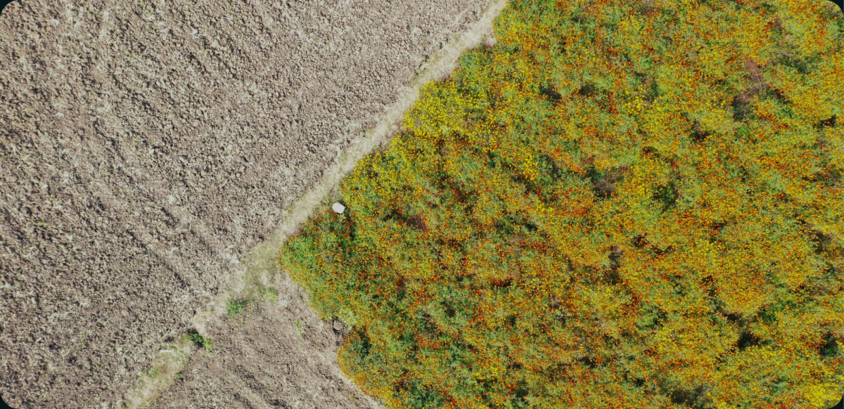
With the European Union Deforestation Regulation (EUDR) set to take effect on December 30, 2024, businesses in the EU and those exporting to it face a tight deadline to ensure they comply with the regulation’s requirements. EUDR aims to combat deforestation and promotes the protection of forests in global supply chains. Commodities such as cocoa, coffee, soy, palm oil, rubber, and wood fall under its scope, necessitating compliance from companies sourcing these materials.
EUDR compliance platforms, especially those that incorporate satellite imagery for deforestation monitoring, are becoming essential tools for companies striving to meet these regulations. By offering deforestation alerts and near-real-time monitoring, these platforms help businesses reduce their environmental impact, stay compliant, and avoid hefty fines.
The European Union Deforestation Regulation is a critical piece of legislation aimed at reducing the negative environmental impact of deforestation, including climate change, biodiversity loss, and ecosystem disruption. Businesses dealing with high-risk commodities must provide evidence that their supply chains do not contribute to deforestation, particularly after the cut-off date of December 31, 2020.
Non-compliance can lead to severe penalties such as exclusion from EU markets, fines, and product confiscation. To avoid these risks, companies are increasingly adopting EUDR compliance platforms and deforestation monitoring tools. These solutions ensure businesses can track, document, and report the status of forests in their supply chain effectively.
Complying with EUDR requires more than just occasional audits or manual reviews. Given the complexity and global reach of many supply chains, businesses need advanced technologies such as satellite data platforms to monitor forests for changes in land use and forest cover.
Tracking deforestation in near-real time is one of the most significant challenges for businesses. Satellite imagery is key to solving this, providing high-resolution images that allow for continuous observation of forests. Companies can use platforms like Orbify, which offer deforestation alerts and near real-time monitoring of forest cover changes. These tools help detect illegal logging and unsanctioned land clearing activities promptly.
Historical satellite data is another critical feature of EUDR compliance software. This allows businesses to prove that no deforestation occurred after the EUDR’s cut-off date of December 31, 2020. Access to this data ensures companies can verify the history of land use and demonstrate the sustainability of their raw material sources.
Companies trading in commodities like palm oil, coffee, and soy—which have been linked to deforestation—use this data to verify that their materials are sourced responsibly. By relying on deforestation monitoring tools, companies can confirm compliance with EUDR regulations and mitigate risks associated with illegal land use.
Transparency is a core requirement of EUDR. Businesses need to provide geolocation data for all the land from which their commodities are sourced. EUDR compliance platforms that integrate satellite data enable companies to offer verifiable proof of origin for their materials, enhancing supply chain visibility.
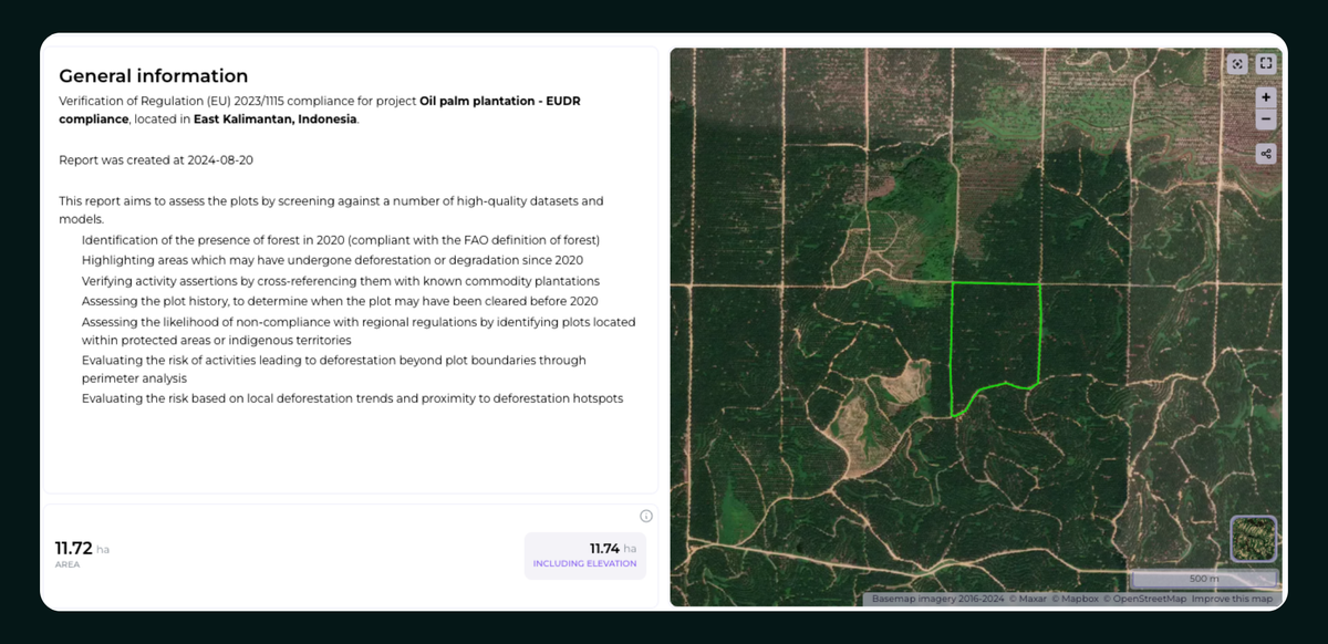
When using Orbify, the first feature you’ll encounter is a comprehensive plot overview. This feature allows users to quickly access detailed information about the plot under examination for EUDR compliance. With just a few clicks, you’ll have all the essential data on the location and specifics of the plot at your fingertips, ensuring you’re well-equipped for analysis.
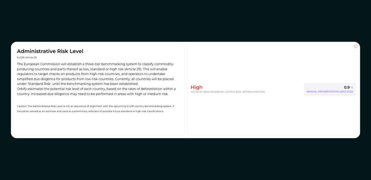
Next, our platform assesses the deforestation risk level of the plot through a three-tier benchmarking system, as outlined in EUDR Article 29. This system categorizes commodity-producing countries and regions as low, standard, or high risk. Such classification helps regulators target products from high-risk countries for further checks, while operators in low-risk regions benefit from simplified due diligence. Orbify estimates the risk levels based on deforestation rates, offering businesses a clearer understanding of the potential environmental risks in each country, state, or jurisdiction.
Additionally, Orbify includes a compliance assessment in line with EUDR Deforestation-Free requirements (Article 2). This feature screens the plot for forest cover presence as of December 2020, while also identifying any deforestation that occurred since then. The platform uses the EC JRC Global Forest Cover benchmark dataset to pinpoint forest presence within the plot in 2020. For more precise analysis, the platform also integrates the WRI DataLab Tropical Tree Cover Extent map, providing enhanced sensitivity to fragmented forests, urban forests, and areas with low canopy cover.
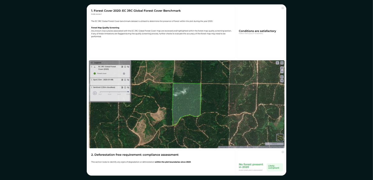
Another valuable feature is the Forest Map Quality Screening, which identifies potential map limitations affecting the project plot, such as small project areas, steep slopes, and regions with low canopy cover. This ensures an accurate representation of the plot while addressing challenges posed by the dataset’s inherent constraints.
The platform further incorporates Sentinel 2 time series data to facilitate a visual examination of plot activities. Any detected inaccuracies in the map undergo further review in the forest map quality screening, with flagged limitations subjected to accuracy checks for precise compliance reporting.
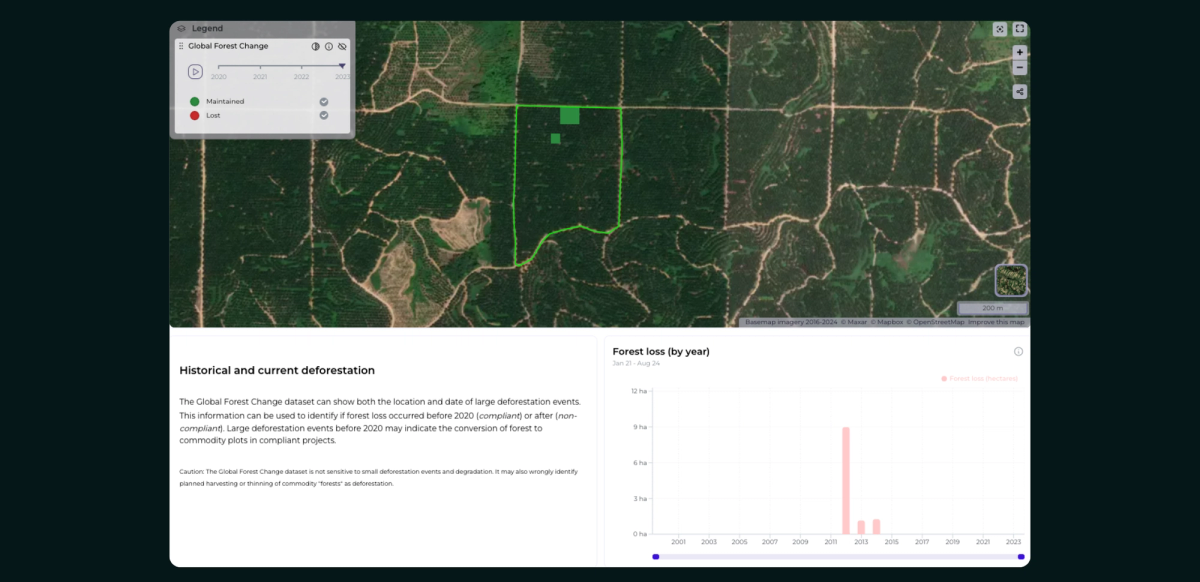
In terms of deforestation monitoring, Orbify can verify Deforestation-Free compliance by screening the plot for indicators of non-compliance since 2020. The Global Forest Change dataset is used to assess the location and date of significant deforestation events, helping determine whether forest loss occurred before (compliant) or after (non-compliant) the 2020 cut-off date. The identification of large deforestation events prior to 2020 can indicate that the forest was converted into commodity plots, potentially meeting EUDR compliance criteria.
Orbify employs several datasets and models to detect the presence of plantations, verify commodity production within the project area, and highlight any conversions of forests to agricultural land.
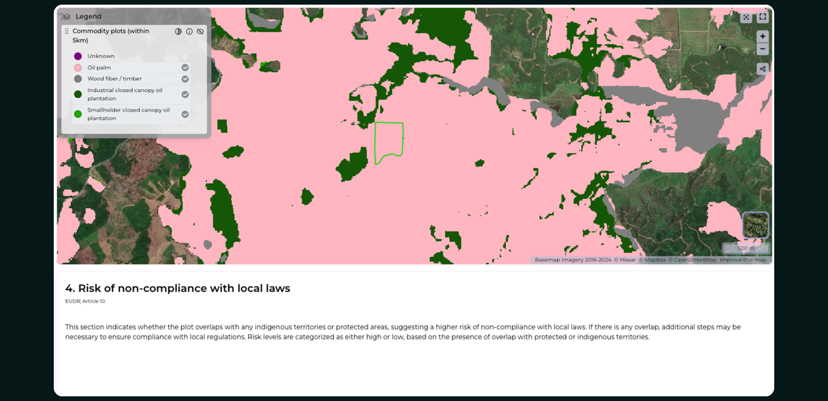
The platform also evaluates the project’s compliance with local laws (Article 10). Datasets for Indigenous territories and protected areas are crucial for determining whether the activities in the region require additional permissions to meet local legal standards. This assessment ensures that your project complies not only with EUDR regulations but also with the relevant local laws.
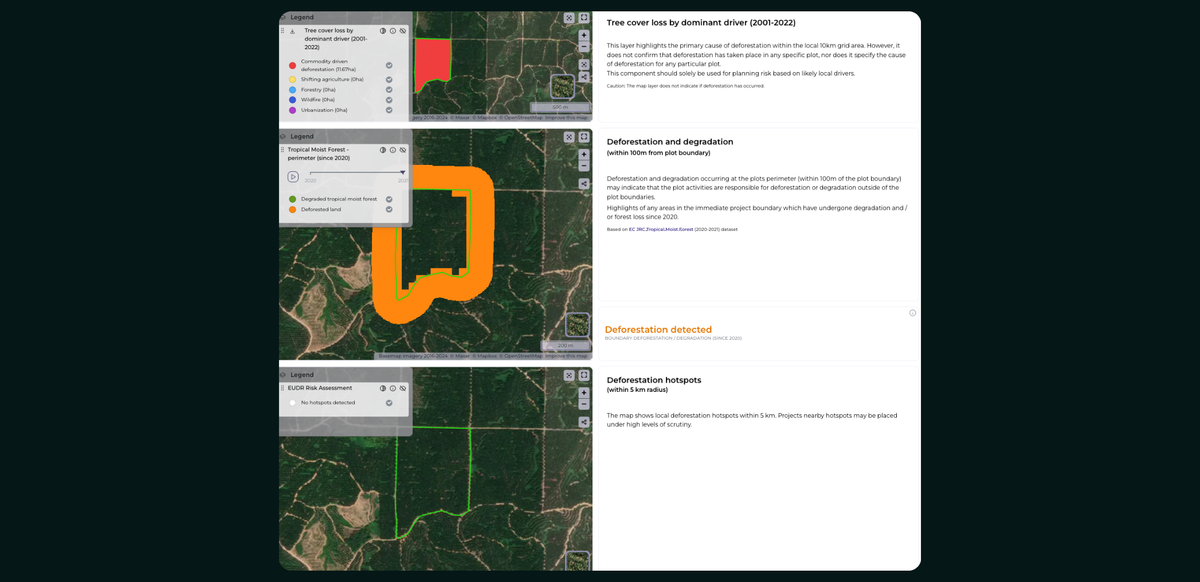
The EUDR risk assessment uses various indicators and datasets to evaluate deforestation and forest degradation within and around the project area. Key metrics include:
• Tree Cover Loss by Dominant Driver: This dataset highlights the primary causes of tree cover loss within each 10 km grid of the project area, detailing the extent and severity of forest loss from 2001 to 2022.
• Deforestation and degradation: This examines deforestation and degradation within 100 meters of the project boundary, identifying whether plot activities lead to deforestation beyond the established boundaries. Data from the Tropical Moist Forest dataset (2020-2021) is utilized for this analysis.
• Nearby Deforestation: Projects located within 5 km of deforestation hotspots or regions of significant forest loss are subject to heightened scrutiny. Orbify helps businesses navigate these zones by identifying potential risks that could impact surrounding forests.
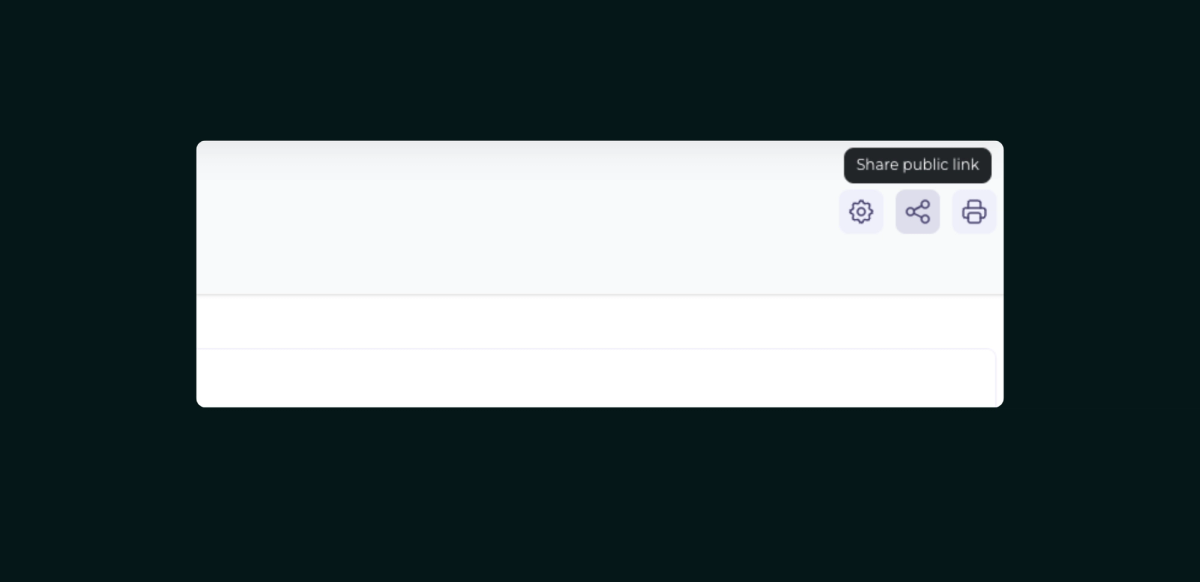
To further facilitate EUDR compliance, Orbify simplifies the data collection process through its shareable supplier data collection feature. With just a secure and convenient link, businesses can efficiently gather essential data from suppliers, ensuring accurate compliance information is readily available.
Incorporating these advanced features, Orbify provides businesses with the tools they need to ensure EUDR compliance, monitor deforestation risk, and promote sustainable practices in their supply chains. By leveraging satellite data and advanced analysis, companies can reduce their environmental impact and contribute to global forest conservation efforts.