Cancún, Mexico. Contains modified Copernicus Sentinel data (2021), processed by ESA, CC BY-SA 3.0 IGO
In January 2022, the volcano Hunga Ha’apai located in Tonga islands erupted, causing a long giant wave that has interested the whole Pacific Ocean. The explosion was shot by several satellites and the spectacular
images of the eruption and the Hunga Tonga Island (completely swept away) went around the world, allowing everybody to know its incredible force and size.
This example briefly reports the high potential satellites for earth observation have and which role they play in the earth-awareness.
But, from where does their power come, and why satellites are going to play a growing role in the future? Let’s try to answer this question starting from the beginning.
The story of a success
The desire to observe and dominate the landscape from a privileged point of view is innate in humankind. When the technology became mature enough, at the end of the 19th century, the first balloons and aircraft with photo cameras to capture the landscape appeared for the first time. From that point on, aerial images became the unique tool for the documentation of areas from the sky and played a central role during the two World Wars for the military intelligence services.
However, it was during the Cold War, with the “space conquest”, that rockets with automated sensors started to rotate around the globe. They were able to monitor simultaneously large portions of the Earth and provide information about settlements, roads, and strategic infrastructures. As a perfect tool designed for non-stop monitoring, the USA government, between 1959 and 1972, adopted this technology to lead enormous satellite missions for spying surveillance of the Soviet Union — and its alleys — territories with the CORONA program, which covered millions of kilometers of Earth surface through sophisticated telescopic camera systems.
Only with the first satellite of the Landsat series, launched in 1972, did the world see the first spacecraft provided with a sensor able to capture imagery in a digital format with multispectral information. Besides the
multispectral technology, the main innovation was its goal: to observe the earth’s surface for environmental and protection purposes, as the US Interior secretary in the 1966 press release for the announcement of the mission claimed: “the time is right and it is urgent to apply space technology towards the solution of Environment Monitoring pressing natural resources problems being compounded by population and industrial growth”.
This became the success key of the satellite for Earth Observation. Spectacular and unexpected mages started to reveal to the general public unexplored world spots, long-period vegetation life cycles, and large area dynamics, as well as one-time disruptive events. The practical applications of satellite applications grew beside the satellite mission numbers. Nations and private companies launch their spacecraft with more advanced sensors for specific use monitoring like land, water, and atmosphere.
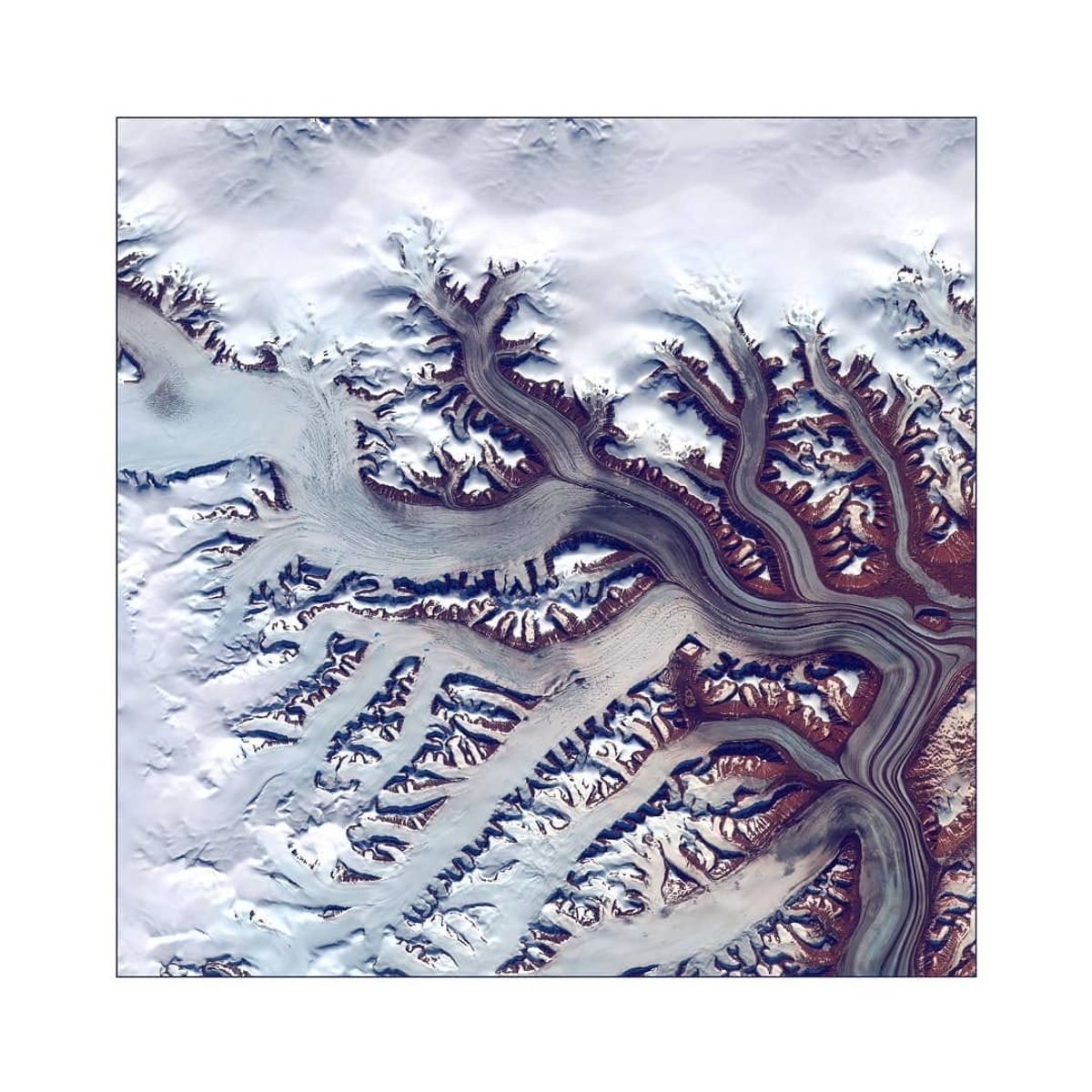
Glacier / Greenland - 08/08/2018 - 69° 34' 14" N / 025° 04 40" W
Colorful means meaningful
Satellites for Earth observation have the role to spot the world’s surface for various purposes. Also referred to “as remote sensing — for the transported sensors (active or passive)” that can gather information from a remote
source without touching it -, these eyes-in-the-sky capture the Sun’s electromagnetic radiations reflected by the Earth’s surface, record them, and send the data to ground stations, which elaborate these sources in raw
images, finally decoded by dedicated software in platforms such as Orbify.
The product of these operations displays images composed of numerous levels of information. Every single element on Earth (from the air to a house’s roof) reflects its radiations (spectral signature): displayed by image bands. Their combination and algorithmic calculation through a vivid color palette allow emphasizing elements, issues, and interesting data of the displayed territory.
Satellite sensors could work actively, too: in contrast to the sensor dedicated to getting earth radiations, these special sensors send energy waves toward the Earth’s surface and, then, record these waves after they have hit the Earth’s surface. Radar satellites could be less spectacular and more difficult to read than optical products, but offer an invaluable service: they can work night and day and whit every cloud condition and assist in various tasks and aims that optical satellites cannot achieve.
One image, hundred values
From the early years of the seventies of the last century, satellite images have become more and more available to a wider consumer base, from governmental agencies to educational organizations, institutions, communities, and individuals, and have conquered almost every branch of industrial and commercial fields. The strong connection with #geospatial applications (GIS, spatial data, remote sensing, SAR, etc…), the technological growth displayed by high-quality imagery, and the easy access provided by #open source imagery have pushed forward the potentialities of the satellite remote sensing data: Farming activities and the correct management of agricultural resources, today more than ever, the need for satellite information to plan and estimate productions, and new companies and start-ups are popping up to run satellite data-driven services. People can now offer these services to governments, space organizations, and basically anyone here!
Increasing high-resolution imagery allows a better landscape design and delivers a detailed overview for urban planning, urban development, and land cover change detection in cities.
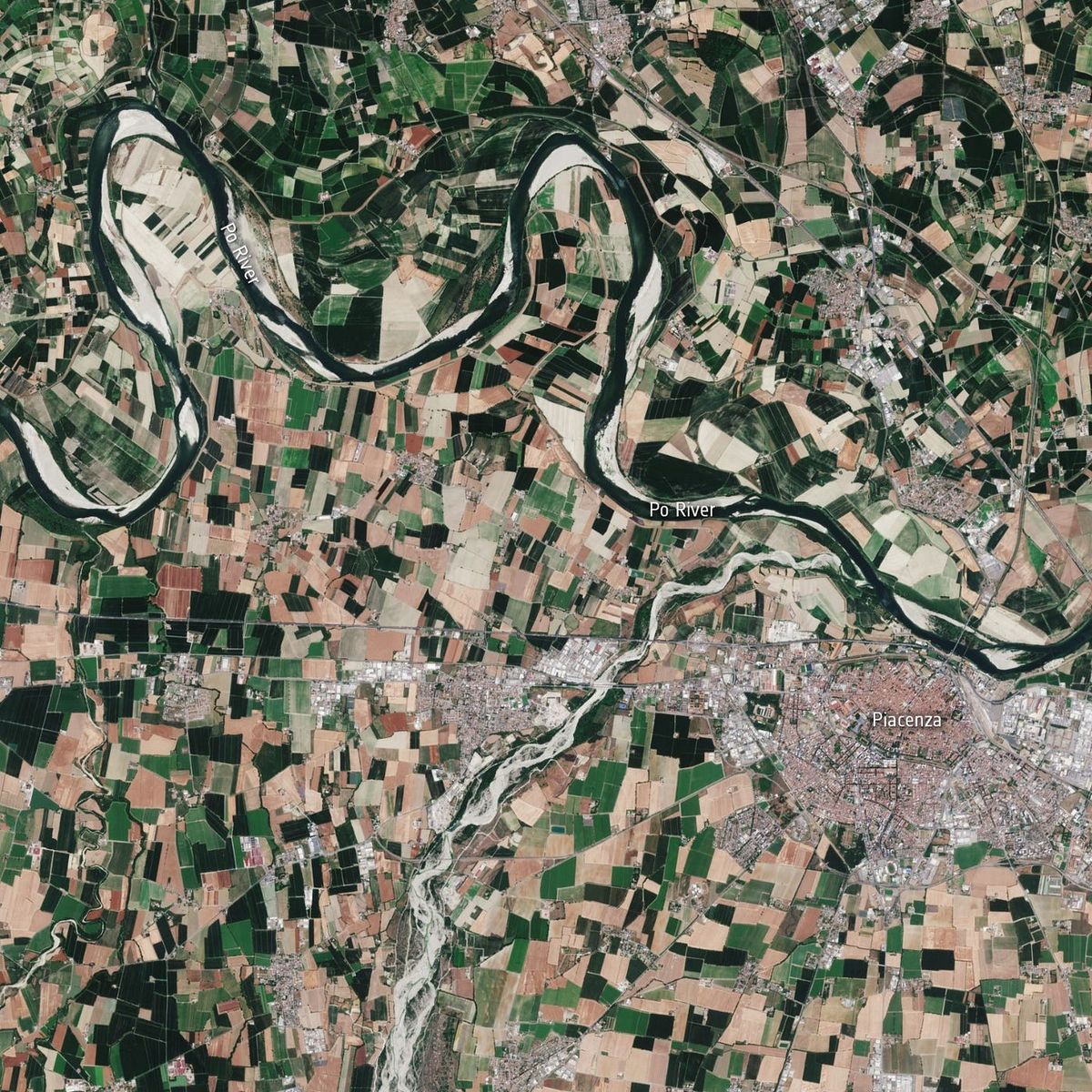
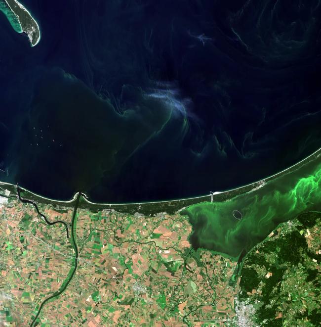
The Po River, the longest river in Italy, is hitting record low water levels after months without heavy rainfall. June 20, 2022. Credits: contains modified Copernicus Sentinel data (2020–22), processed by ESA, CC BY-SA 3.0 IGO
Environmental protection takes advantage of the data collected by Earth observation technologies. Meteorological forecast, air pollution analysis, flood mapping, deforestation, and increase-decrease in snow levels are only some of the versatile data extractable from satellite images.
Humanitarian aid can be sent where natural disasters happen: the constant satellite time and land monitoring make available images of the hit places and map faster the area where people are in need. These are only some of the potentialities offered by the Earth observations applications.
Online geo navigation platforms, like Google Earth and Bing Map, have however the merit of (a sort of) “democratization” of this powerful documentation resource. The words “satellite imagery” are already part of our vocabulary and the curiosity and fascination of everyone — or, as said at the beginning of this article, the innate desire to dominate the land from “the sky” — toward satellites images will contribute to increasing the Earth observation technology use in the everyday activities.