PRESS RELEASE
Last edited: March 4, 2025
Published: March 4, 2025
Orbify expands carbon project insights with Cecil’s data platform
Orbify expands carbon project insights with Cecil’s data platform
Cecil is supporting Orbify to access a greater range of datasets by eliminating data pipeline build time and simplifying dataset selection. By leveraging Cecil’s data platform, Orbify has expanded their catalog of available insights from best in class nature data providers, providing customers with additional options for granular insights, trend analysis, and project monitoring.
Orbify: enabling clients to screen and develop carbon projects
Orbify’s platform streamlines the assessment of carbon project impact, additionality, and risks by combining real-time monitoring with fast analysis. Pre-built templates support clients in developing high-integrity projects and ensuring alignment with the latest industry standards.
Through rapid methodology alignment and near real-time project eligibility monitoring, developers and investors understand whether their potential projects are likely to be high-integrity.
Cecil: unlocking nature data at scale
Cecil’s platform includes an API and analytical database, providing seamless access to a range of nature datasets. With Cecil, Orbify was able to securely connect their data operations and leverage a modern SQL database in their workflow to analyse time-series and spatial data at scale.
The Orbify team wanted to enable clients with additional aboveground biomass datasets for carbon projects in their platform. Previously, this would have required searching for and identifying potential datasets, building a custom data pipeline, procuring licensing, and paying for large quotas to make the data available. However, through Cecil’s data platform, Orbify spatial data team quickly and efficiently gained access to datasets in analysis ready format, streamlining the development process.
Example: Visualizing an ARR project with Orbify
Orbify’s ARR Carbon Project Template provides a comprehensive description of a new or existing project’s total area, location, ecoregion, and biome, as well as the size of the largest contiguous area within the project. The template can quickly indicate if a project meets the most critical eligibility and monitoring criteria based on Verra’s VM0047 methodology. This includes assessing whether land has been cleared of native forest within the last 10 years, determining if the site is viable for a new ARR project, and identifying land within the wider project area that may be suitable for ARR projects.
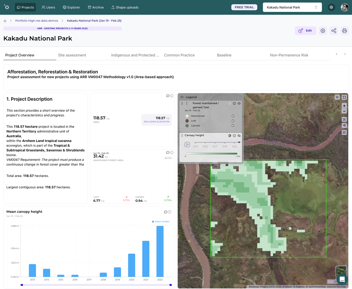
Example use case: quantifying the aboveground live canopy cover (%), and canopy height (m) of terrestrial plants at 30 m spatial resolution in Kakadu National Park, Australia.
Press contact
Orbify PR
press.release@orbify.com