Last edited: August 28, 2024
Published: March 18, 2024

Konstantinos Madias
Sustainability Copywriter
Blog Post
Last edited: August 28, 2024
Published: March 18, 2024
Konstantinos Madias
Sustainability Copywriter
In our previous article, we delved into the challenges surrounding the screening of carbon projects, highlighting key obstacles such as additionality, verification, and accurate carbon capture estimates. These challenges underscore the importance of thorough screening processes to ensure the integrity and effectiveness of carbon offset initiatives.
In this article, we pivot our focus to delve into the role of satellite data in addressing the challenges associated with screening carbon offset projects. Through the utilization of satellite imagery, our aim is to augment the screening process, offering valuable insights that enhance the effectiveness of climate change mitigation strategies.
Satellite technology is allowing us to monitor environmental changes with unprecedented detail and accuracy. From tracking changes in land use to providing information on historical deforestation, satellite data provides invaluable information for assessing the viability and feasibility of carbon projects. Ultimately, our goal is to demonstrate how satellite technology can enhance the transparency, validity, and overall effectiveness of carbon offset projects, paving the way for a more sustainable future.
To offer a comprehensive analysis of how satellite data contributes to rapid carbon project screening, it's essential to begin with an overview of key terms and concepts.
A carbon offset project is a certified environmental initiative aimed at reducing, avoiding, or removing greenhouse gas (GHG) emissions from the atmosphere to mitigate climate change. These projects are vital for offsetting carbon emissions generated elsewhere by individuals, businesses, or governments.
Governments and companies, as outlined in Article 12 of the Kyoto Protocol, may finance carbon offset projects to reduce emissions and promote sustainable development, particularly in developing countries. Financial support enables the implementation of activities that result in emissions reductions.
Financing carbon offset projects serves to compensate for CO2 emissions by supporting initiatives that counterbalance these emissions. Each tonne of emissions reduced by a project generates one carbon offset or carbon credit, tradable on the market. Individuals and companies can invest directly in these projects or purchase carbon credits to offset their carbon footprints, leveraging analytics to assess the impact.
Carbon credits represent a vital mechanism for steering businesses towards sustainability by providing a tangible way to offset carbon emissions. These credits signify the reduction or avoidance of one tonne of carbon dioxide emissions through investments in sustainable projects, such as reforestation or renewable energy initiatives. Engaging in carbon credit schemes enables businesses to mitigate their environmental impact and demonstrate a commitment to sustainability.
Despite their importance, the carbon offset industry faces challenges, including credibility issues and a lack of standardized protocols for ensuring the credibility of carbon credits. Integrity and transparency are crucial in voluntary carbon markets, highlighting the need for better screening of carbon projects to ensure transparency and verify their validity. Screening processes are essential to assess the feasibility of carbon offset projects and ensure their effectiveness in reducing emissions and promoting sustainability.
Carbon project screening serves as a critical checkpoint in the journey of carbon offset projects, ensuring their potential, feasibility, and integrity before further advancement. This essential process involves evaluating each project's environmental, social, and economic viability through various steps.
The initial phase of carbon screening involves conducting a thorough Initial Feasibility Assessment to assess the technical and financial aspects of carbon offsetting projects. This rigorous analysis determines whether proposed ideas can effectively reduce carbon footprints and combat climate change using renewable energy sources and innovative carbon capture techniques.
Following this, an Environmental Impact Analysis is conducted to evaluate both the positive environmental benefits and potential negative impacts of the projects. This examination ensures that initiatives contribute to reducing greenhouse gas emissions while minimizing adverse effects on local ecosystems and biodiversity.
Stakeholder Engagement emerges as another crucial step, emphasizing the involvement of local communities and stakeholders from the outset, incorporating geospatial data to better understand and analyse community landscapes. By aligning projects with corporate social responsibility goals and addressing environmental concerns with geospatial data, this approach secures participation and support from those directly affected.
However, navigating the screening process poses challenges due to the interdisciplinary nature of carbon projects. In addressing these challenges, satellite technology emerges as a valuable tool. By providing valuable insights into environmental factors such as atmospheric changes, ecosystem health, and pollution levels, satellite data enhances the screening process for carbon projects.
Satellite data plays a pivotal role in addressing key challenges within carbon offset projects, offering invaluable insights and solutions to enhance transparency, accuracy, and efficiency. By monitoring large land areas quickly and accurately, satellite imagery provides visual evidence of changes in land use and land cover, essential for verifying environmental insights. This capability ensures the integrity of carbon offset projects by offering a reliable mean of quantifying carbon-related activities.
Moreover, satellite data contributes to the transparency, accuracy, credibility, and auditability of carbon removal projects, serving as an invaluable tool in both remote and developed regions. It allows monitoring of deforestation and land use changes, enabling proactive interventions to prevent further environmental degradation.
Furthermore, advancements in digital platforms integrating satellite data offer promising solutions to streamline data collection, analysis, and accessibility. These platforms, such as Orbify, are reducing costs and time associated with screening carbon projects. Through these advancements, satellite data and geospatial technology continue to revolutionize the carbon market, driving sustainability and accountability in climate action initiatives.
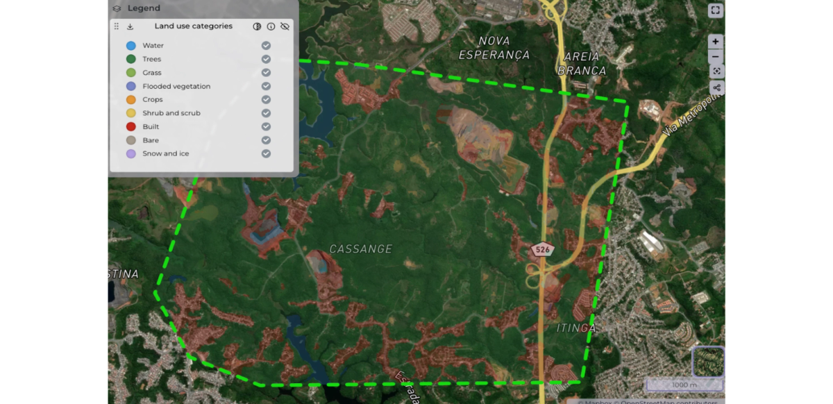
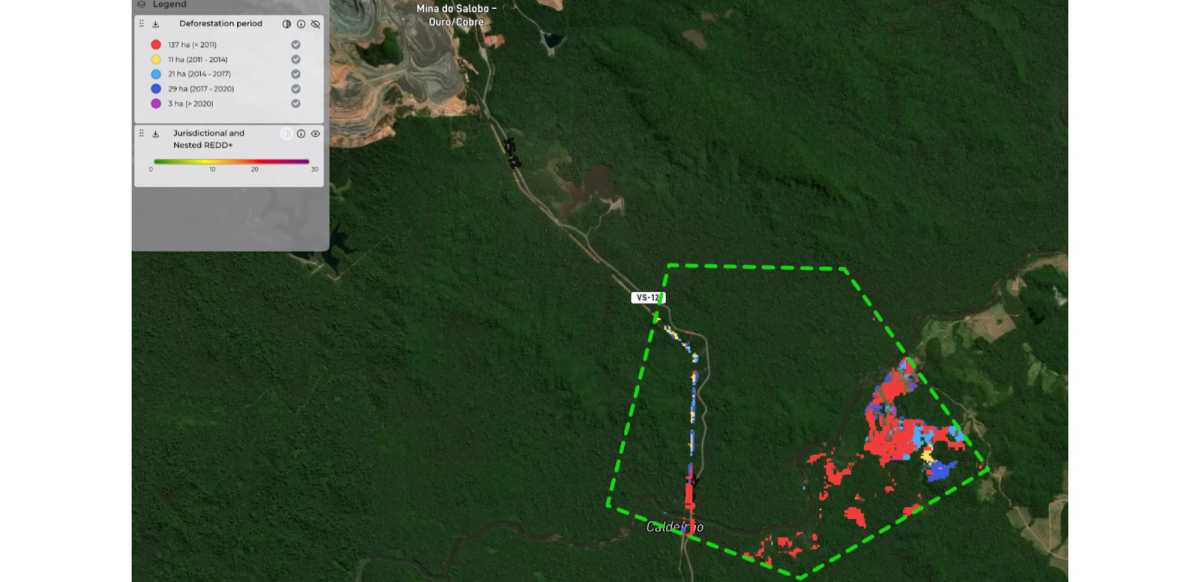
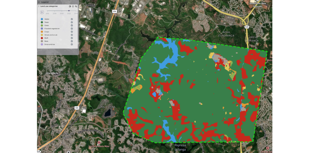
Satellite data plays a vital role in screening carbon projects by monitoring environmental conditions and changes within project areas. This ongoing surveillance keeps project developers informed about the forest status and detects any potential encroachment or illegal activities. Furthermore, satellite data assists in identifying suitable project sites by assessing the land use and other environmental factors such as biomass, vegetation cover, and soil characteristics (screenshots below from Orbify’s Geospatial Data Platform). This information is crucial for determining the feasibility of carbon sequestration projects, ensuring they can achieve their carbon mitigation goals effectively.
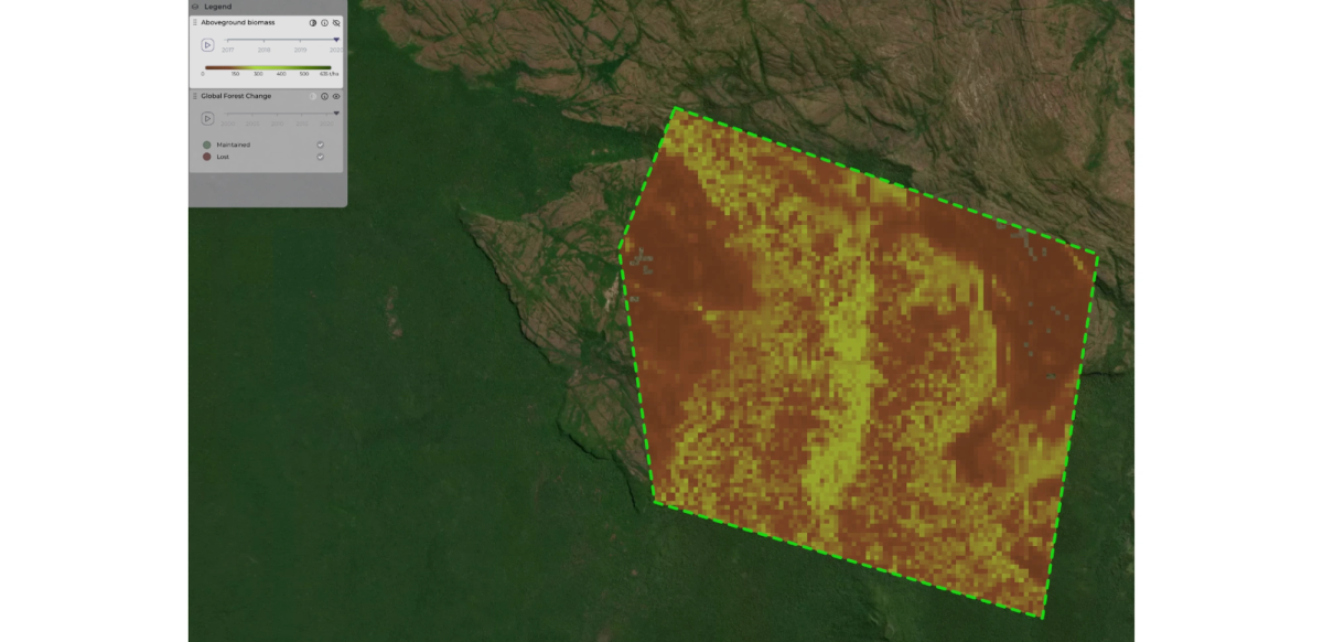
Moreover, satellite technology offers estimations of carbon stock in forests and ecosystems, which are essential for screening carbon projects and for optimizing offset initiatives. By assessing carbon stock through satellite imagery, project developers can better understand the carbon sequestration potential of proposed initiatives and make informed decisions during the screening process. In the context of screening carbon projects, estimations of carbon enable stakeholders to evaluate the feasibility and effectiveness of potential initiatives. By analyzing satellite data to determine the existing carbon stock within project areas, developers can assess whether proposed projects have the capacity to sequester additional carbon and contribute to emission reduction goals.
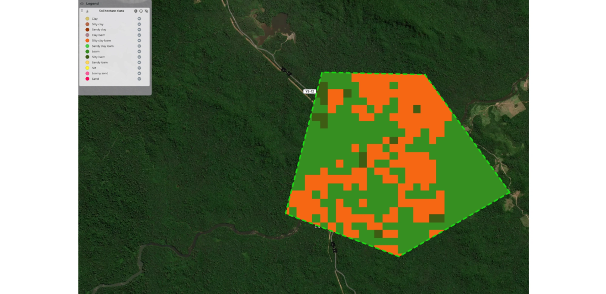
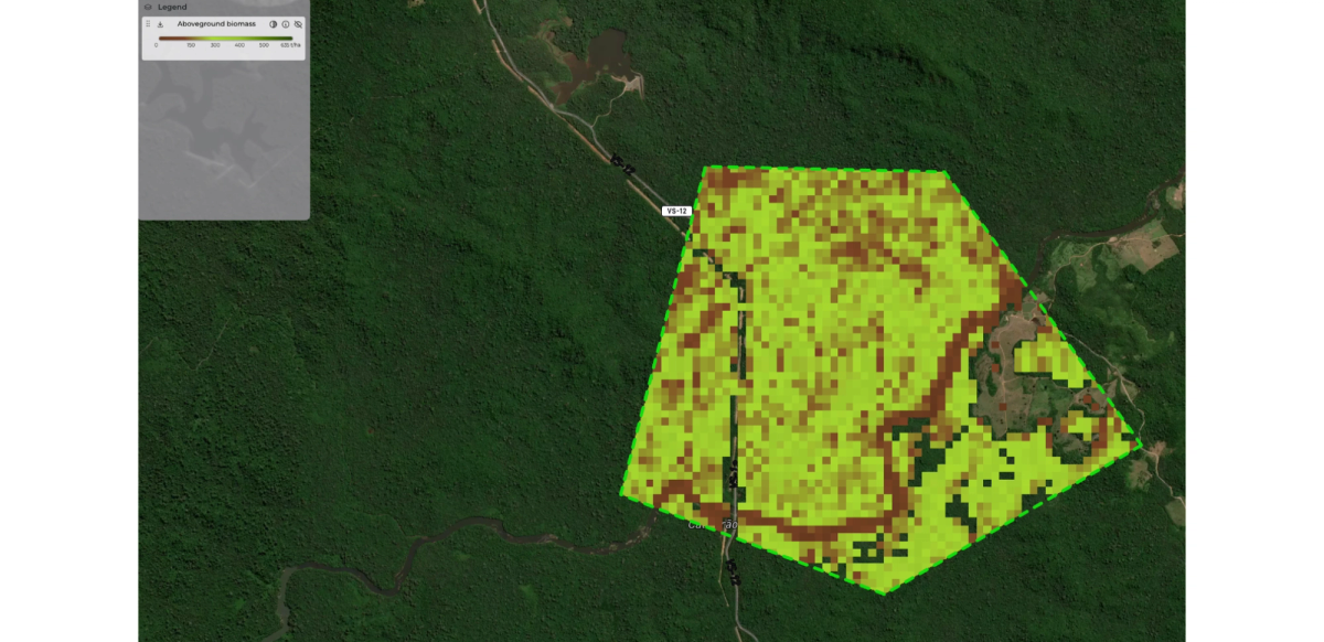
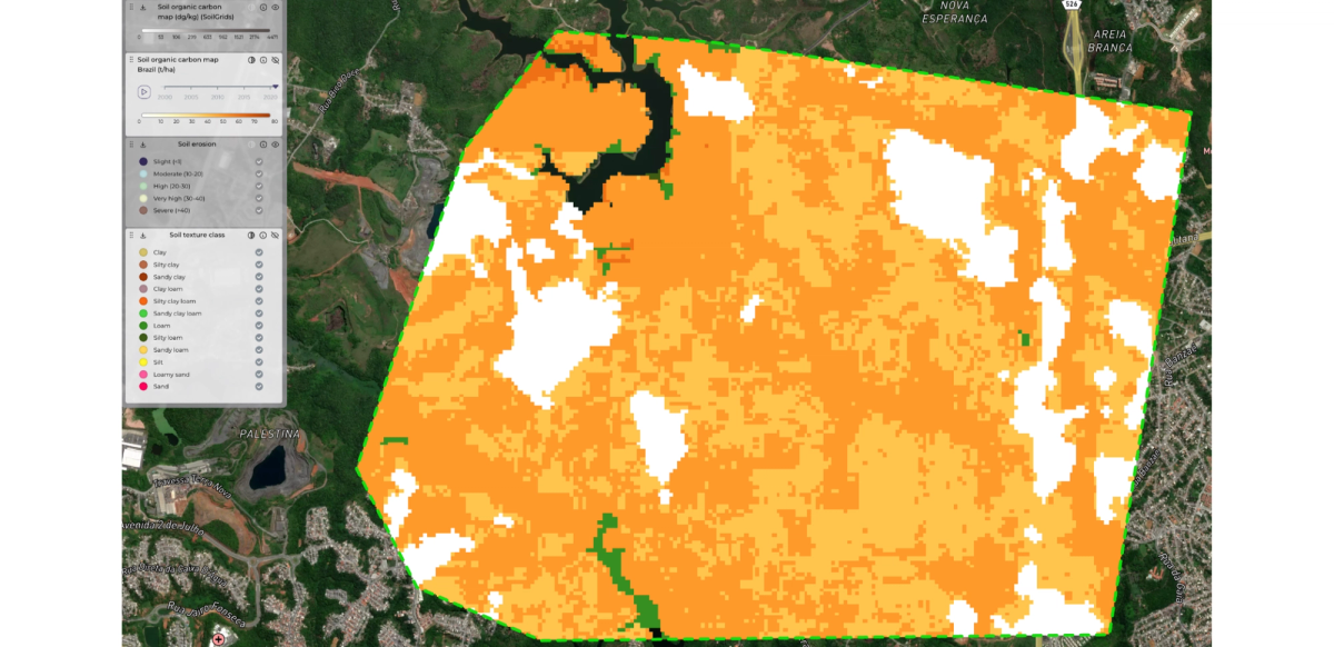
Additionally, satellite data can provide information on canopy height, above and below-ground biomass, historical deforestation, and soil organic carbon (screenshots below from Orbify’s Geospatial Data Platform). These data points are crucial for carbon screening, baseline, and verification processes, further enhancing the accuracy and reliability of carbon offset initiatives. During the screening phase, this information allows project developers to track reforestation efforts and monitor forest growth over time.
Additionality and permanence are fundamental considerations in the evaluation and screening process of carbon offset projects, and satellite technology serves as a cornerstone in assessing these critical components. Additionality, a key principle in carbon offsetting, ensures that projects yield tangible climate benefits that would not have occurred under business-as-usual circumstances.
Satellite technology facilitates monitoring and evaluation of project sites, allowing developers to track changes in land cover, and other environmental parameters over time. By assessing the effectiveness of interventions satellite-derived data helps verify the additionality of projects and ensures they deliver meaningful climate benefits. Additionally, satellite imagery due to the historical data enables stakeholders to detect and respond to potential risks or challenges that may threaten the sustainability of carbon offset projects, such as encroachment into protected areas or changes in land use patterns (screenshots below from Orbify’s Geospatial Data Platform).
In parallel, the concept of permanence is paramount in ensuring the long-term effectiveness and sustainability of the carbon projects. Permanence refers to the ability of projects to maintain stored carbon dioxide emissions or removals over extended periods, thereby delivering enduring climate benefits. Satellite technology plays a crucial role in assessing permanence by monitoring project areas. Satellite-derived insights allow project developers to track forest growth and biomass accumulation (screenshots below from Orbify’s Geospatial Data Platform). By integrating satellite data into permanence assessments, stakeholders can implement strategies to mitigate risks and enhance project resilience.
Incorporating satellite-derived insights into both additionality and permanence assessments enhances the robustness and credibility of carbon offset projects. By providing objective data on project effectiveness, environmental impact, and long-term sustainability, satellite technology empowers stakeholders to make informed decisions, secure financing, and drive meaningful contributions to global climate action.
In summary, satellite data offers valuable information for screening carbon projects, from establishing baselines to evaluating the project area. By leveraging satellite technology, project developers can make informed decisions, optimize project activities, and ensure the long-term success of carbon offset initiatives.